Capanema elevation
Capanema (Pará), Brazil elevation is 30 meters and Capanema elevation in feet is 98 ft above sea level [src 1]. Capanema is a populated place (feature code) with elevation that is 352 meters (1155 ft) smaller than average city elevation in Brazil.
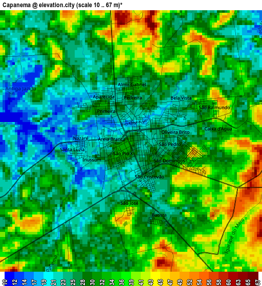
Below is the Elevation map of Capanema, which displays elevation range with different colors. Scale of the first map is from 10 to 67 m (33 to 220 ft) with average elevation of 30.6 meters (=100 ft) [note 1]
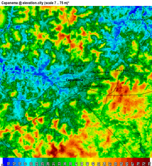
These maps also provides idea of topography and contour of this city, they are displayed at different zoom levels. More info about maps, scale and edge coordinates you can find below images.
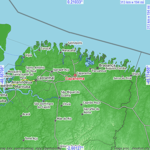
| \ | Map #1 | Map #2 | Topo.Map |
| Scale [m] | 10..67 m | 7..75 m | × |
| Scale [ft] | 33..220 ft | 23..246 ft | × |
| Average | 30.6 m = 100 ft | 35 m = 115 ft | × |
| Width | 9.77 km = 6.1 mi | 19.54 km = 12.1 mi | 312.6 km = 194.2 mi |
| Height | 9.77 km = 6.1 mi | 19.54 km = 12.1 mi | 312.7 km = 194.3 mi |
| ↑Max Latitude | -1.151894° | -1.107957° | 0.21033° |
| Latitude at center | -1.19583° | -1.19583° | -1.19583° |
| ↓Min Latitude | -1.239765° | -1.2837° | -2.60127° |
| ← Min Longitude | -47.224775° | -47.268721° | -48.58708° |
| Longitude center | -47.18083° | -47.18083° | -47.18083° |
| →Max Longitude | -47.136885° | -47.092939° | -45.77458° |
Nearby cities:
Cities around Capanema sort by population:
• Bragança elevation 16 m
48.8 km,  71°
71°
• Salinópolis 10 m
67.6 km,  343°
343°
• Capitão Poço 69 m
62.7 km,  167°
167°
• São Miguel do Guamá 9 m
58.5 km,  215°
215°
• Igarapé Açu 39 m
49.4 km,  278°
278°
• Augusto Corrêa 7 m
63.7 km, 72°
• Santa Maria do Pará 51 m
47.1 km,  248°
248°
• Maracanã 21 m
56.6 km,  327°
327°
• Marapanim 10 m
78.5 km,  312°
312°
• São João de Pirabas 26 m
46.8 km,  0°
0°
• Ourém 14 m
40.3 km, 169°
• Irituia 18 m
70.1 km,  204°
204°
Multilingual:
 En español:
Capanema elevación 30 m.
 En France:
Capanema élévation 30 m.


Sources and notes:
- [note 1] Map square and city borders are not equal. Map elevation data is calculated only from area inside that square.
- [src 1] Elevation data from geonames database provided with same terms of usage.
- [src 2] The elevation map of Capanema is generated using elevation data from NASA's 3 arcsec (90m) resolution SRTM data.
- [src 3] Base (background) map © OpenStreetMap contributors tiles are generated by Geofabrik and OpenTopoMap.
Copyright & License:
This Capanema Elevation Map is licensed under CC BY-SA. You may reuse any part from this page, if you give a proper credit by linking to this URL:
 More info on terms of use page.