Conceição do Araguaia elevation
Conceição do Araguaia (Pará), Brazil elevation is 180 meters and Conceição do Araguaia elevation in feet is 591 ft above sea level [src 1]. Conceição do Araguaia is a populated place (feature code) with elevation that is 202 meters (663 ft) smaller than average city elevation in Brazil.
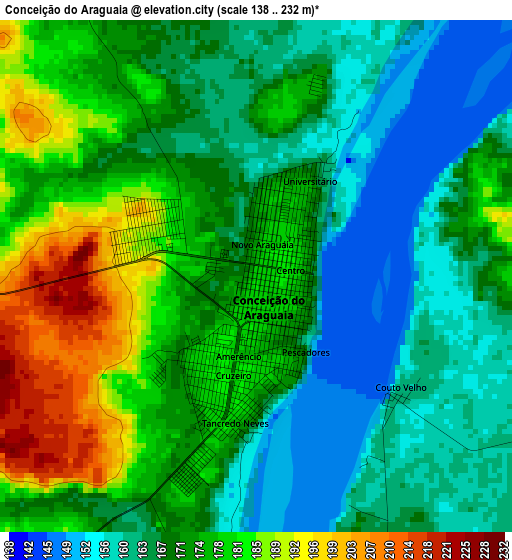
Below is the Elevation map of Conceição do Araguaia, which displays elevation range with different colors. Scale of the first map is from 138 to 232 m (453 to 761 ft) with average elevation of 171.3 meters (=562 ft) [note 1]
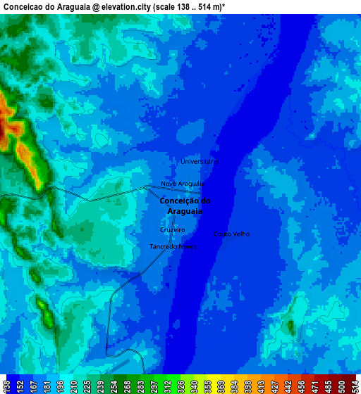
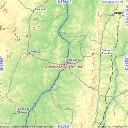
These maps also provides idea of topography and contour of this city, they are displayed at different zoom levels. More info about maps, scale and edge coordinates you can find below images.
| \ | Map #1 | Map #2 | Topo.Map |
| Scale [m] | 138..232 m | 138..514 m | × |
| Scale [ft] | 453..761 ft | 453..1686 ft | × |
| Average | 171.3 m = 562 ft | 185.1 m = 607 ft | × |
| Width | 9.67 km = 6 mi | 19.34 km = 12 mi | 309.4 km = 192.3 mi |
| Height | 9.67 km = 6 mi | 19.34 km = 12 mi | 309.5 km = 192.3 mi |
| ↑Max Latitude | -8.220919° | -8.177423° | -6.87044° |
| Latitude at center | -8.26441° | -8.26441° | -8.26441° |
| ↓Min Latitude | -8.307897° | -8.351378° | -9.65347° |
| ← Min Longitude | -49.313765° | -49.357711° | -50.67607° |
| Longitude center | -49.26982° | -49.26982° | -49.26982° |
| →Max Longitude | -49.225875° | -49.181929° | -47.86357° |
Nearby cities:
Cities around Conceição do Araguaia sort by population:
• Palmas elevation 271 m
235.5 km,  153°
153°
• Parauapebas 169 m
254 km,  344°
344°
• Araguaína 237 m
167.2 km,  44°
44°
• Redenção 224 m
87.8 km,  287°
287°
• Xinguara 252 m
149.4 km,  330°
330°
• Tucumã 302 m
268.2 km,  308°
308°
• Ourilândia do Norte 267 m
261.1 km, 310°
• Santa Luzia 197 m
236.4 km,  72°
72°
• Miracema do Tocantins 195 m
174 km, 146°
• Carolina 175 m
224.3 km,  62°
62°
• São Geraldo do Araguaia 131 m
221.7 km,  20°
20°
• Santa Terezinha 204 m
280.7 km,  209°
209°
Multilingual:
 En español:
Conceição do Araguaia elevación 180 m.
 En France:
Conceição do Araguaia élévation 180 m.
 Auf Deutsch:
Conceição do Araguaia höhe über dem Meeresspiegel ist 180 m.
 На русском:
Conceição do Araguaia высота над уровнем моря 180 м
Sources and notes:
- [note 1] Map square and city borders are not equal. Map elevation data is calculated only from area inside that square.
- [src 1] Elevation data from geonames database provided with same terms of usage.
- [src 2] The elevation map of Conceição do Araguaia is generated using elevation data from NASA's 3 arcsec (90m) resolution SRTM data.
- [src 3] Base (background) map © OpenStreetMap contributors tiles are generated by Geofabrik and OpenTopoMap.
Copyright & License:
This Conceição do Araguaia Elevation Map is licensed under CC BY-SA. You may reuse any part from this page, if you give a proper credit by linking to this URL:
 More info on terms of use page.