Maués elevation
Maués (Amazonas), Brazil elevation is 19 meters and Maués elevation in feet is 62 ft above sea level [src 1]. Maués is a populated place (feature code) with elevation that is 363 meters (1191 ft) smaller than average city elevation in Brazil.
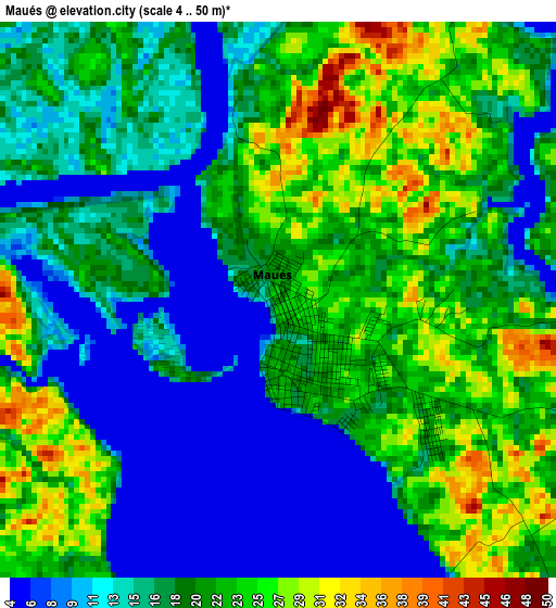
Below is the Elevation map of Maués, which displays elevation range with different colors. Scale of the first map is from 4 to 50 m (13 to 164 ft) with average elevation of 18.2 meters (=60 ft) [note 1]
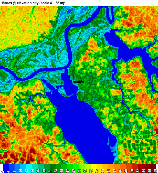
These maps also provides idea of topography and contour of this city, they are displayed at different zoom levels. More info about maps, scale and edge coordinates you can find below images.
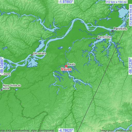
| \ | Map #1 | Map #2 | Topo.Map |
| Scale [m] | 4..50 m | 4..58 m | × |
| Scale [ft] | 13..164 ft | 13..190 ft | × |
| Average | 18.2 m = 60 ft | 24.8 m = 81 ft | × |
| Width | 9.76 km = 6.1 mi | 19.51 km = 12.1 mi | 312.1 km = 193.9 mi |
| Height | 9.76 km = 6.1 mi | 19.51 km = 12.1 mi | 312.2 km = 194 mi |
| ↑Max Latitude | -3.33974° | -3.295869° | -1.97893° |
| Latitude at center | -3.38361° | -3.38361° | -3.38361° |
| ↓Min Latitude | -3.427478° | -3.471343° | -4.78625° |
| ← Min Longitude | -57.762555° | -57.806501° | -59.12486° |
| Longitude center | -57.71861° | -57.71861° | -57.71861° |
| →Max Longitude | -57.674665° | -57.630719° | -56.31236° |
Nearby cities:
Cities around Maués sort by population:
• Itacoatiara elevation 19 m
84.9 km,  288°
288°
• Itaituba 13 m
216.6 km,  117°
117°
• Parintins 17 m
137.7 km,  52°
52°
• Terra Santa 21 m
197.4 km,  43°
43°
• Juruti 25 m
226.7 km, 52°
• Nova Olinda do Norte 22 m
162.9 km,  249°
249°
• Barreirinha 13 m
97.4 km, 47°
• Urucurituba 37 m
56.5 km,  300°
300°
• Guajará 5 m
46.7 km,  7°
7°
• Autazes 23 m
158.2 km,  262°
262°
• Urucará 17 m
94.3 km,  357°
357°
• Nhamundá 1 m
173.8 km, 39°
Multilingual:
 En español:
Maués elevación 19 m.
 En France:
Maués élévation 19 m.


Sources and notes:
- [note 1] Map square and city borders are not equal. Map elevation data is calculated only from area inside that square.
- [src 1] Elevation data from geonames database provided with same terms of usage.
- [src 2] The elevation map of Maués is generated using elevation data from NASA's 3 arcsec (90m) resolution SRTM data.
- [src 3] Base (background) map © OpenStreetMap contributors tiles are generated by Geofabrik and OpenTopoMap.
Copyright & License:
This Maués Elevation Map is licensed under CC BY-SA. You may reuse any part from this page, if you give a proper credit by linking to this URL:
 More info on terms of use page.