Óbidos elevation
Óbidos (Pará), Brazil elevation is 27 meters and Óbidos elevation in feet is 89 ft above sea level [src 1]. Óbidos is a seat of a second-order administrative division (feature code) with elevation that is 355 meters (1165 ft) smaller than average city elevation in Brazil.
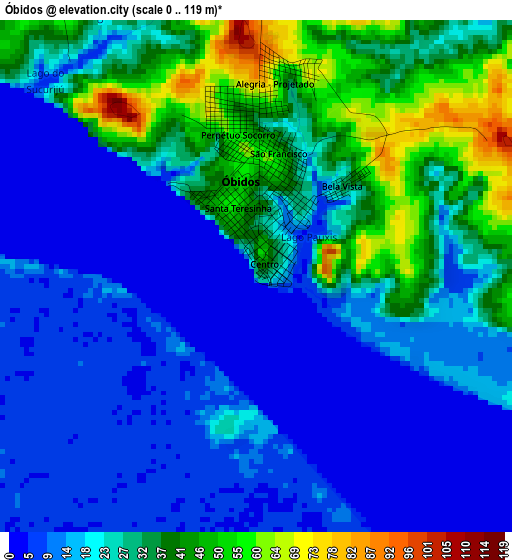
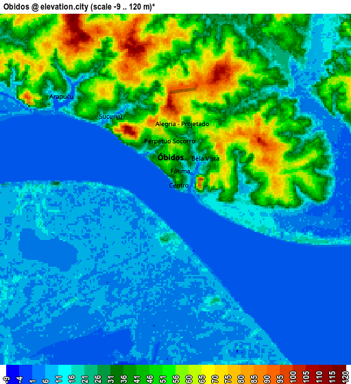
Below is the Elevation map of Óbidos, which displays elevation range with different colors. Scale of the first map is from 0 to 119 m (0 to 390 ft) with average elevation of 22.5 meters (=74 ft) [note 1]
These maps also provides idea of topography and contour of this city, they are displayed at different zoom levels. More info about maps, scale and edge coordinates you can find below images.
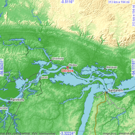
| \ | Map #1 | Map #2 | Topo.Map |
| Scale [m] | 0..119 m | -9..120 m | × |
| Scale [ft] | 0..390 ft | -30..394 ft | × |
| Average | 22.5 m = 74 ft | 22.6 m = 74 ft | × |
| Width | 9.77 km = 6.1 mi | 19.53 km = 12.1 mi | 312.5 km = 194.2 mi |
| Height | 9.77 km = 6.1 mi | 19.53 km = 12.1 mi | 312.5 km = 194.2 mi |
| ↑Max Latitude | -1.873579° | -1.829656° | -0.5116° |
| Latitude at center | -1.9175° | -1.9175° | -1.9175° |
| ↓Min Latitude | -1.96142° | -2.005339° | -3.32224° |
| ← Min Longitude | -55.562005° | -55.605951° | -56.92431° |
| Longitude center | -55.51806° | -55.51806° | -55.51806° |
| →Max Longitude | -55.474115° | -55.430169° | -54.11181° |
Nearby cities:
Cities around Óbidos sort by population:
• Santarém elevation 51 m
107.3 km,  123°
123°
• Parintins 17 m
156.7 km,  239°
239°
• Oriximiná 34 m
42.2 km,  293°
293°
• Alenquer 32 m
86.7 km,  91°
91°
• Monte Alegre 57 m
160 km, 93°
• Terra Santa 21 m
109.6 km,  259°
259°
• Juruti 25 m
68.9 km,  247°
247°
• Barreirinha 13 m
198 km, 240°
• Guajará 5 m
265.7 km, 243°
• Urucará 17 m
258.4 km, 254°
• Nhamundá 1 m
136.1 km, 257°
• Prainha 35 m
226.9 km, 86°
Multilingual:
 En español:
Óbidos elevación 27 m.
 En France:
Óbidos élévation 27 m.


Sources and notes:
- [note 1] Map square and city borders are not equal. Map elevation data is calculated only from area inside that square.
- [src 1] Elevation data from geonames database provided with same terms of usage.
- [src 2] The elevation map of Óbidos is generated using elevation data from NASA's 3 arcsec (90m) resolution SRTM data.
- [src 3] Base (background) map © OpenStreetMap contributors tiles are generated by Geofabrik and OpenTopoMap.
Copyright & License:
This Óbidos Elevation Map is licensed under CC BY-SA. You may reuse any part from this page, if you give a proper credit by linking to this URL:
 More info on terms of use page.