Picos elevation
Picos (Piauí), Brazil elevation is 203 meters and Picos elevation in feet is 666 ft above sea level [src 1]. Picos is a populated place (feature code) with elevation that is 179 meters (587 ft) smaller than average city elevation in Brazil.
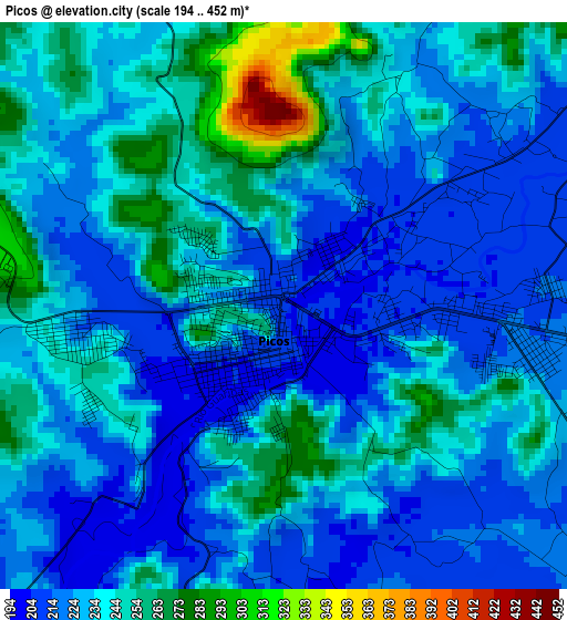
Below is the Elevation map of Picos, which displays elevation range with different colors. Scale of the first map is from 194 to 452 m (636 to 1483 ft) with average elevation of 232.8 meters (=764 ft) [note 1]
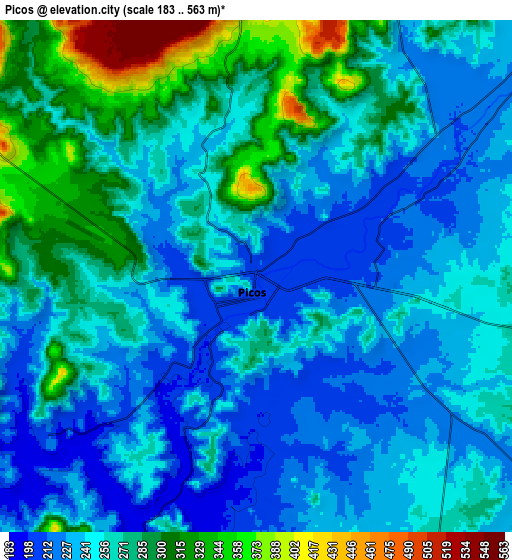
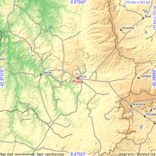
These maps also provides idea of topography and contour of this city, they are displayed at different zoom levels. More info about maps, scale and edge coordinates you can find below images.
| \ | Map #1 | Map #2 | Topo.Map |
| Scale [m] | 194..452 m | 183..563 m | × |
| Scale [ft] | 636..1483 ft | 600..1847 ft | × |
| Average | 232.8 m = 764 ft | 258.8 m = 849 ft | × |
| Width | 9.7 km = 6 mi | 19.4 km = 12.1 mi | 310.3 km = 192.8 mi |
| Height | 9.7 km = 6 mi | 19.4 km = 12.1 mi | 310.3 km = 192.8 mi |
| ↑Max Latitude | -7.033327° | -6.989711° | -5.67943° |
| Latitude at center | -7.07694° | -7.07694° | -7.07694° |
| ↓Min Latitude | -7.120548° | -7.164153° | -8.47023° |
| ← Min Longitude | -41.510885° | -41.554831° | -42.87319° |
| Longitude center | -41.46694° | -41.46694° | -41.46694° |
| →Max Longitude | -41.422995° | -41.379049° | -40.06069° |
Nearby cities:
Cities around Picos sort by population:
• Araripina elevation 624 m
120.4 km,  117°
117°
• Oeiras 181 m
73.5 km,  274°
274°
• Campos Sales 567 m
120.4 km,  89°
89°
• Ipueiras 558 m
112.3 km, 87°
• Valença do Piauí 336 m
80.5 km,  337°
337°
• Jaicós 290 m
48 km,  130°
130°
• Simplício Mendes 292 m
99.3 km,  209°
209°
• Inhuma 391 m
52.6 km,  329°
329°
• Pio IX 498 m
101.5 km,  74°
74°
• Simões 442 m
92.2 km, 129°
• Pimenteiras 280 m
92.6 km,  3°
3°
• Itainópolis 195 m
41.2 km,  181°
181°
Multilingual:
 En español:
Picos elevación 203 m.
 En France:
Picos élévation 203 m.


Sources and notes:
- [note 1] Map square and city borders are not equal. Map elevation data is calculated only from area inside that square.
- [src 1] Elevation data from geonames database provided with same terms of usage.
- [src 2] The elevation map of Picos is generated using elevation data from NASA's 3 arcsec (90m) resolution SRTM data.
- [src 3] Base (background) map © OpenStreetMap contributors tiles are generated by Geofabrik and OpenTopoMap.
Copyright & License:
This Picos Elevation Map is licensed under CC BY-SA. You may reuse any part from this page, if you give a proper credit by linking to this URL:
 More info on terms of use page.