Poço Branco elevation
Poço Branco (Rio Grande do Norte), Brazil elevation is 87 meters and Poço Branco elevation in feet is 285 ft above sea level [src 1]. Poço Branco is a populated place (feature code) with elevation that is 295 meters (968 ft) smaller than average city elevation in Brazil.
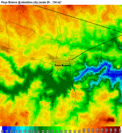
Below is the Elevation map of Poço Branco, which displays elevation range with different colors. Scale of the first map is from 29 to 134 m (95 to 440 ft) with average elevation of 86.1 meters (=282 ft) [note 1]
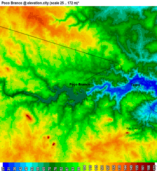
These maps also provides idea of topography and contour of this city, they are displayed at different zoom levels. More info about maps, scale and edge coordinates you can find below images.
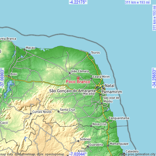
| \ | Map #1 | Map #2 | Topo.Map |
| Scale [m] | 29..134 m | 25..172 m | × |
| Scale [ft] | 95..440 ft | 82..564 ft | × |
| Average | 86.1 m = 282 ft | 95.2 m = 312 ft | × |
| Width | 9.73 km = 6 mi | 19.45 km = 12.1 mi | 311.2 km = 193.4 mi |
| Height | 9.73 km = 6 mi | 19.45 km = 12.1 mi | 311.2 km = 193.4 mi |
| ↑Max Latitude | -5.579044° | -5.535306° | -4.22175° |
| Latitude at center | -5.62278° | -5.62278° | -5.62278° |
| ↓Min Latitude | -5.666512° | -5.710241° | -7.02044° |
| ← Min Longitude | -35.706725° | -35.750671° | -37.06903° |
| Longitude center | -35.66278° | -35.66278° | -35.66278° |
| →Max Longitude | -35.618835° | -35.574889° | -34.25653° |
Nearby cities:
Cities around Poço Branco sort by population:
• Natal elevation 32 m
53.7 km,  110°
110°
• Parnamirim 56 m
54.9 km,  126°
126°
• Macaíba 16 m
43.1 km, 127°
• Ceará Mirim 37 m
26.3 km,  92°
92°
• João Câmara 152 m
19.8 km,  298°
298°
• Extremoz 48 m
40.4 km,  103°
103°
• São Miguel 23 m
37.1 km,  62°
62°
• São Gonçalo do Amarante 15 m
41.5 km,  117°
117°
• São Paulo do Potengi 78 m
32.2 km,  200°
200°
• Touros 9 m
52.2 km,  25°
25°
• São Tomé 167 m
60 km,  229°
229°
• Taipu 42 m
7.3 km, 89°
Multilingual:
 En español:
Poço Branco elevación 87 m.
 En France:
Poço Branco élévation 87 m.
 Auf Deutsch:
Poço Branco höhe über dem Meeresspiegel ist 87 m.

Sources and notes:
- [note 1] Map square and city borders are not equal. Map elevation data is calculated only from area inside that square.
- [src 1] Elevation data from geonames database provided with same terms of usage.
- [src 2] The elevation map of Poço Branco is generated using elevation data from NASA's 3 arcsec (90m) resolution SRTM data.
- [src 3] Base (background) map © OpenStreetMap contributors tiles are generated by Geofabrik and OpenTopoMap.
Copyright & License:
This Poço Branco Elevation Map is licensed under CC BY-SA. You may reuse any part from this page, if you give a proper credit by linking to this URL:
 More info on terms of use page.