Soure elevation
Soure (Pará), Brazil elevation is 17 meters and Soure elevation in feet is 56 ft above sea level [src 1]. Soure is a populated place (feature code) with elevation that is 365 meters (1198 ft) smaller than average city elevation in Brazil.
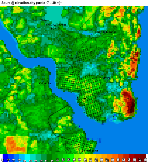
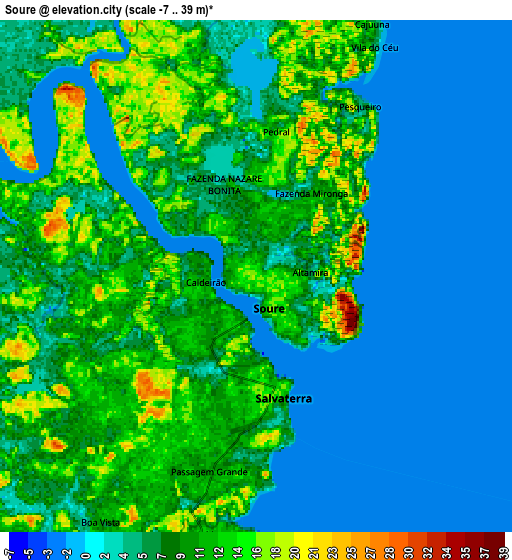
Below is the Elevation map of Soure, which displays elevation range with different colors. Scale of the first map is from -7 to 39 m (-23 to 128 ft) with average elevation of 9.1 meters (=30 ft) [note 1]
These maps also provides idea of topography and contour of this city, they are displayed at different zoom levels. More info about maps, scale and edge coordinates you can find below images.
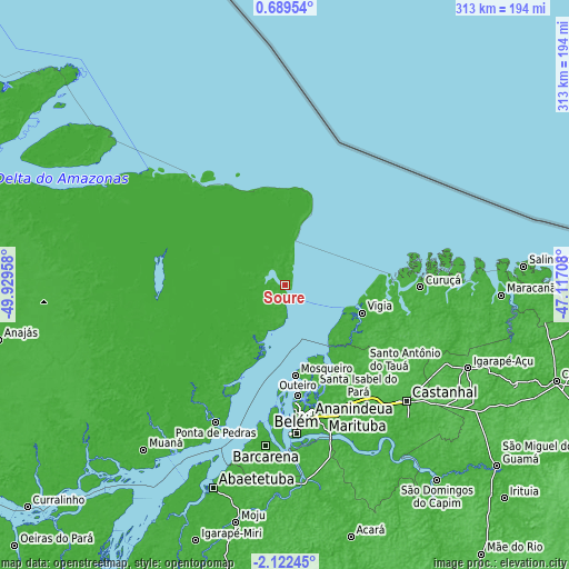
| \ | Map #1 | Map #2 | Topo.Map |
| Scale [m] | -7..39 m | -7..39 m | × |
| Scale [ft] | -23..128 ft | -23..128 ft | × |
| Average | 9.1 m = 30 ft | 7.1 m = 23 ft | × |
| Width | 9.77 km = 6.1 mi | 19.54 km = 12.1 mi | 312.7 km = 194.3 mi |
| Height | 9.77 km = 6.1 mi | 19.54 km = 12.1 mi | 312.7 km = 194.3 mi |
| ↑Max Latitude | -0.672728° | -0.628785° | 0.68954° |
| Latitude at center | -0.71667° | -0.71667° | -0.71667° |
| ↓Min Latitude | -0.760612° | -0.804553° | -2.12245° |
| ← Min Longitude | -48.567275° | -48.611221° | -49.92958° |
| Longitude center | -48.52333° | -48.52333° | -48.52333° |
| →Max Longitude | -48.479385° | -48.435439° | -47.11708° |
Nearby cities:
Cities around Soure sort by population:
• Belém elevation 15 m
82.2 km,  178°
178°
• Ananindeua 19 m
74.1 km,  166°
166°
• Castanhal 46 m
92.3 km,  134°
134°
• Benevides 31 m
78.1 km,  156°
156°
• Barcarena 9 m
88.5 km,  187°
187°
• Vigia 6 m
45.3 km,  110°
110°
• Igarapé Açu 39 m
110.4 km, 114°
• Curuçá 15 m
75.1 km,  91°
91°
• Marapanim 10 m
91.6 km, 90°
• Santo Antônio do Tauá 18 m
65.3 km,  137°
137°
• São Caetano de Odivelas 8 m
56.1 km, 93°
• Bujaru 18 m
103.5 km,  149°
149°
Multilingual:
 En español:
Soure elevación 17 m.
 En France:
Soure élévation 17 m.


Sources and notes:
- [note 1] Map square and city borders are not equal. Map elevation data is calculated only from area inside that square.
- [src 1] Elevation data from geonames database provided with same terms of usage.
- [src 2] The elevation map of Soure is generated using elevation data from NASA's 3 arcsec (90m) resolution SRTM data.
- [src 3] Base (background) map © OpenStreetMap contributors tiles are generated by Geofabrik and OpenTopoMap.
Copyright & License:
This Soure Elevation Map is licensed under CC BY-SA. You may reuse any part from this page, if you give a proper credit by linking to this URL:
 More info on terms of use page.