Ascención de Guarayos elevation
Ascención de Guarayos (Santa Cruz), Bolivia elevation is 248 meters and Ascención de Guarayos elevation in feet is 814 ft above sea level [src 1]. Ascención de Guarayos is a populated locality (feature code) with elevation that is 1628 meters (5341 ft) smaller than average city elevation in Bolivia.
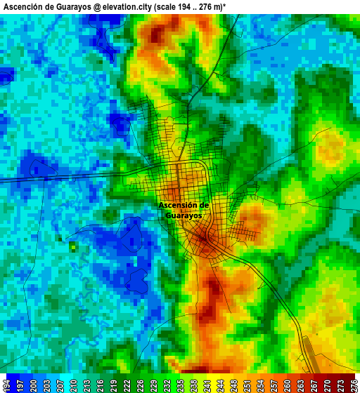
Below is the Elevation map of Ascención de Guarayos, which displays elevation range with different colors. Scale of the first map is from 194 to 276 m (636 to 906 ft) with average elevation of 222 meters (=728 ft) [note 1]
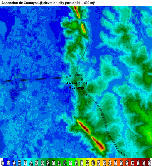
These maps also provides idea of topography and contour of this city, they are displayed at different zoom levels. More info about maps, scale and edge coordinates you can find below images.
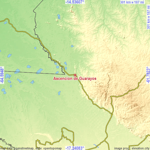
| \ | Map #1 | Map #2 | Topo.Map |
| Scale [m] | 194..276 m | 191..400 m | × |
| Scale [ft] | 636..906 ft | 627..1312 ft | × |
| Average | 222 m = 728 ft | 223.5 m = 733 ft | × |
| Width | 9.4 km = 5.8 mi | 18.8 km = 11.7 mi | 300.7 km = 186.8 mi |
| Height | 9.4 km = 5.8 mi | 18.8 km = 11.7 mi | 300.8 km = 186.9 mi |
| ↑Max Latitude | -15.85072° | -15.808441° | -14.53607° |
| Latitude at center | -15.89299° | -15.89299° | -15.89299° |
| ↓Min Latitude | -15.935251° | -15.977503° | -17.24083° |
| ← Min Longitude | -63.232495° | -63.276441° | -64.5948° |
| Longitude center | -63.18855° | -63.18855° | -63.18855° |
| →Max Longitude | -63.144605° | -63.100659° | -61.7823° |
Nearby cities:
Cities around Ascención de Guarayos sort by population:
• Montero elevation 300 m
160.9 km,  182°
182°
• Warnes 340 m
180.5 km, 179°
• Villa Yapacaní 297 m
181.1 km,  202°
202°
• Ascensión 198 m
24.2 km,  27°
27°
• Mineros 258 m
136.4 km, 181°
• Portachuelo 298 m
163.6 km,  187°
187°
• La Bélgica 353 m
184.3 km, 180°
• Santa Rosa del Sara 271 m
142 km, 197°
• Okinawa Número Uno 260 m
154.2 km,  165°
165°
• Buena Vista 370 m
181.5 km, 196°
• San Carlos 320 m
177.9 km, 199°
• Urubichá 295 m
61.3 km,  24°
24°
Multilingual:
 En español:
Ascención de Guarayos elevación 248 m.
 En France:
Ascención de Guarayos élévation 248 m.
 Auf Deutsch:
Ascención de Guarayos höhe über dem Meeresspiegel ist 248 m.
 На русском:
Ascención de Guarayos высота над уровнем моря 248 м
Sources and notes:
- [note 1] Map square and city borders are not equal. Map elevation data is calculated only from area inside that square.
- [src 1] Elevation data from geonames database provided with same terms of usage.
- [src 2] The elevation map of Ascención de Guarayos is generated using elevation data from NASA's 3 arcsec (90m) resolution SRTM data.
- [src 3] Base (background) map © OpenStreetMap contributors tiles are generated by Geofabrik and OpenTopoMap.
Copyright & License:
This Ascención de Guarayos Elevation Map is licensed under CC BY-SA. You may reuse any part from this page, if you give a proper credit by linking to this URL:
 More info on terms of use page.