Bermejo elevation
Bermejo (Tarija), Bolivia elevation is 416 meters and Bermejo elevation in feet is 1365 ft above sea level [src 1]. Bermejo is a populated place (feature code) with elevation that is 1460 meters (4790 ft) smaller than average city elevation in Bolivia.
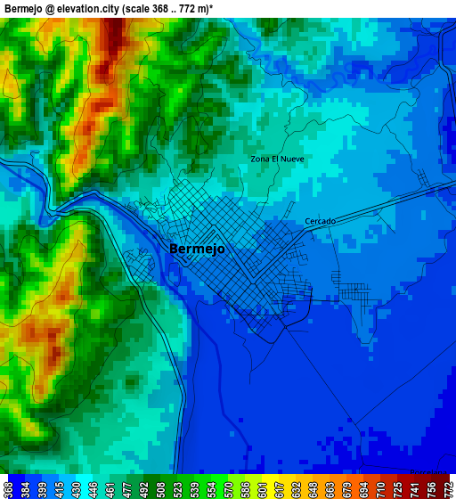
Below is the Elevation map of Bermejo, which displays elevation range with different colors. Scale of the first map is from 368 to 772 m (1207 to 2533 ft) with average elevation of 455.2 meters (=1493 ft) [note 1]
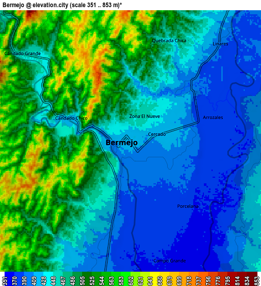
These maps also provides idea of topography and contour of this city, they are displayed at different zoom levels. More info about maps, scale and edge coordinates you can find below images.
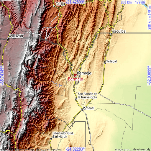
| \ | Map #1 | Map #2 | Topo.Map |
| Scale [m] | 368..772 m | 351..853 m | × |
| Scale [ft] | 1207..2533 ft | 1152..2799 ft | × |
| Average | 455.2 m = 1493 ft | 469.1 m = 1539 ft | × |
| Width | 9.01 km = 5.6 mi | 18.03 km = 11.2 mi | 288.4 km = 179.2 mi |
| Height | 9.01 km = 5.6 mi | 18.03 km = 11.2 mi | 288.4 km = 179.2 mi |
| ↑Max Latitude | -22.691522° | -22.650973° | -21.42899° |
| Latitude at center | -22.73206° | -22.73206° | -22.73206° |
| ↓Min Latitude | -22.772586° | -22.813099° | -24.02283° |
| ← Min Longitude | -64.381185° | -64.425131° | -65.74349° |
| Longitude center | -64.33724° | -64.33724° | -64.33724° |
| →Max Longitude | -64.293295° | -64.249349° | -62.93099° |
Nearby cities:
Cities around Bermejo sort by population:
• Tarija elevation 1870 m
139 km,  343°
343°
• Yacuiba 629 m
104.6 km,  40°
40°
• Villazón 3455 m
147.8 km,  299°
299°
• Camiri 802 m
311.3 km,  15°
15°
• Tupiza 2961 m
202 km,  315°
315°
• Villamontes 388 m
186.3 km,  28°
28°
• Camargo 2412 m
249.4 km, 338°
• Boyuibe 811 m
278 km, 23°
• Entre Ríos 1232 m
135.1 km,  7°
7°
• Santa Bárbara 4732 m
268.3 km, 318°
• Atocha 3675 m
278.8 km, 315°
• Villa Charcas 2954 m
230.5 km,  345°
345°
Multilingual:
 En español:
Bermejo elevación 416 m.
 En France:
Bermejo élévation 416 m.


Sources and notes:
- [note 1] Map square and city borders are not equal. Map elevation data is calculated only from area inside that square.
- [src 1] Elevation data from geonames database provided with same terms of usage.
- [src 2] The elevation map of Bermejo is generated using elevation data from NASA's 3 arcsec (90m) resolution SRTM data.
- [src 3] Base (background) map © OpenStreetMap contributors tiles are generated by Geofabrik and OpenTopoMap.
Copyright & License:
This Bermejo Elevation Map is licensed under CC BY-SA. You may reuse any part from this page, if you give a proper credit by linking to this URL:
 More info on terms of use page.