Malanville elevation
Malanville (Alibori), Benin elevation is 164 meters and Malanville elevation in feet is 538 ft above sea level [src 1]. Malanville is a seat of a third-order administrative division (feature code) with elevation that is 1 meters (3 ft) bigger than average city elevation in Benin.
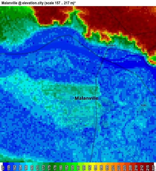
Below is the Elevation map of Malanville, which displays elevation range with different colors. Scale of the first map is from 157 to 217 m (515 to 712 ft) with average elevation of 170.7 meters (=560 ft) [note 1]
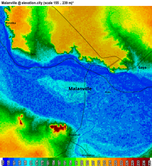
These maps also provides idea of topography and contour of this city, they are displayed at different zoom levels. More info about maps, scale and edge coordinates you can find below images.
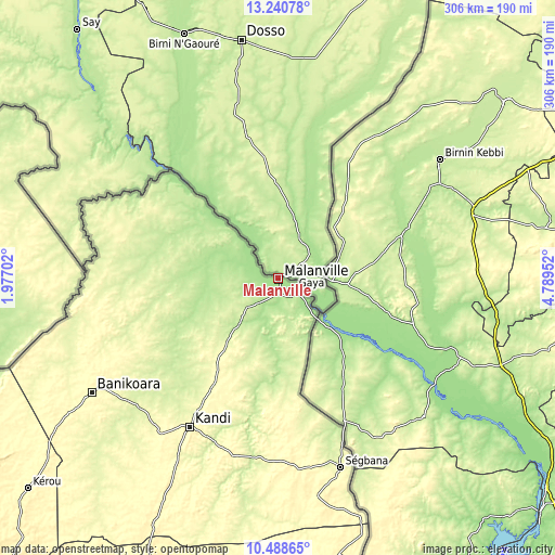
| \ | Map #1 | Map #2 | Topo.Map |
| Scale [m] | 157..217 m | 155..239 m | × |
| Scale [ft] | 515..712 ft | 509..784 ft | × |
| Average | 170.7 m = 560 ft | 181.2 m = 594 ft | × |
| Width | 9.56 km = 5.9 mi | 19.13 km = 11.9 mi | 306 km = 190.1 mi |
| Height | 9.56 km = 5.9 mi | 19.13 km = 11.9 mi | 306 km = 190.1 mi |
| ↑Max Latitude | 11.911193° | 11.954188° | 13.24078° |
| Latitude at center | 11.86819° | 11.86819° | 11.86819° |
| ↓Min Latitude | 11.825181° | 11.782165° | 10.48865° |
| ← Min Longitude | 3.339325° | 3.295379° | 1.97702° |
| Longitude center | 3.38327° | 3.38327° | 3.38327° |
| →Max Longitude | 3.427215° | 3.471161° | 4.78952° |
Nearby cities:
Cities around Malanville sort by population:
• Djougou elevation 444 m
304.7 km,  217°
217°
• Parakou 369 m
293.2 km,  196°
196°
• Kandi 294 m
94.9 km,  210°
210°
• Natitingou 450 m
279.4 km,  231°
231°
• Nikki 403 m
215.2 km,  185°
185°
• Bembèrèkè 445 m
198.5 km, 203°
• Banikoara 312 m
120.8 km,  238°
238°
• Tanguiéta 242 m
269.3 km, 239°
• Bétérou 259 m
321.2 km, 202°
• Guilmaro 472 m
231.7 km, 231°
• Goumori 303 m
141.2 km, 237°
• Angara-Débou 315 m
70 km, 210°
Multilingual:
 En español:
Malanville elevación 164 m.
 En France:
Malanville élévation 164 m.
 Auf Deutsch:
Malanville höhe über dem Meeresspiegel ist 164 m.

Sources and notes:
- [note 1] Map square and city borders are not equal. Map elevation data is calculated only from area inside that square.
- [src 1] Elevation data from geonames database provided with same terms of usage.
- [src 2] The elevation map of Malanville is generated using elevation data from NASA's 3 arcsec (90m) resolution SRTM data.
- [src 3] Base (background) map © OpenStreetMap contributors tiles are generated by Geofabrik and OpenTopoMap.
Copyright & License:
This Malanville Elevation Map is licensed under CC BY-SA. You may reuse any part from this page, if you give a proper credit by linking to this URL:
 More info on terms of use page.