Petrich elevation
Petrich (Blagoevgrad, Obshtina Petrich), Bulgaria elevation is 185 meters and Petrich elevation in feet is 607 ft above sea level [src 1]. Petrich is a populated place (feature code) with elevation that is 134 meters (440 ft) smaller than average city elevation in Bulgaria.
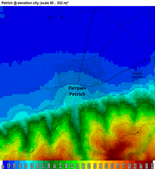
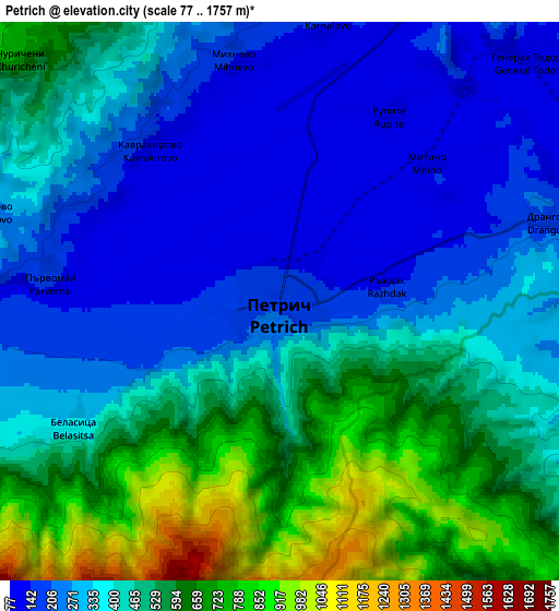
Below is the Elevation map of Petrich, which displays elevation range with different colors. Scale of the first map is from 90 to 932 m (295 to 3058 ft) with average elevation of 273.4 meters (=897 ft) [note 1]
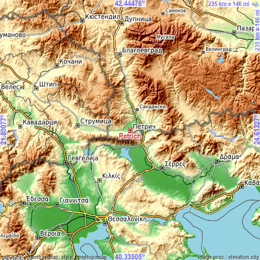
These maps also provides idea of topography and contour of this city, they are displayed at different zoom levels. More info about maps, scale and edge coordinates you can find below images.
| \ | Map #1 | Map #2 | Topo.Map |
| Scale [m] | 90..932 m | 77..1757 m | × |
| Scale [ft] | 295..3058 ft | 253..5764 ft | × |
| Average | 273.4 m = 897 ft | 420.1 m = 1378 ft | × |
| Width | 7.33 km = 4.6 mi | 14.66 km = 9.1 mi | 234.6 km = 145.8 mi |
| Height | 7.33 km = 4.6 mi | 14.66 km = 9.1 mi | 234.6 km = 145.8 mi |
| ↑Max Latitude | 41.431416° | 41.464356° | 42.44476° |
| Latitude at center | 41.39846° | 41.39846° | 41.39846° |
| ↓Min Latitude | 41.365487° | 41.332497° | 40.33505° |
| ← Min Longitude | 23.163075° | 23.119129° | 21.80077° |
| Longitude center | 23.20702° | 23.20702° | 23.20702° |
| →Max Longitude | 23.250965° | 23.294911° | 24.61327° |
Nearby cities:
Cities around Petrich sort by population:
• Sandanski elevation 246 m
19.8 km,  18°
18°
• Gotse Delchev 535 m
47.7 km,  66°
66°
• Razlog 829 m
58.4 km, 21°
• Bansko 929 m
54.2 km,  25°
25°
• Simitli 280 m
54.4 km,  352°
352°
• Kresna 316 m
37.5 km, 352°
• Stara Kresna 561 m
44.7 km,  357°
357°
• Hadzhidimovo 462 m
56.8 km,  75°
75°
• Satovcha 994 m
69 km, 69°
• Garmen 589 m
55.5 km, 66°
• Kolarovo 396 m
9.2 km,  245°
245°
• Strumyani 130 m
26.1 km, 358°
Multilingual:
 En español:
Petrich elevación 185 m.
 En France:
Pétritch élévation 185 m.


Sources and notes:
- [note 1] Map square and city borders are not equal. Map elevation data is calculated only from area inside that square.
- [src 1] Elevation data from geonames database provided with same terms of usage.
- [src 2] The elevation map of Petrich is generated using elevation data from NASA's 3 arcsec (90m) resolution SRTM data.
- [src 3] Base (background) map © OpenStreetMap contributors tiles are generated by Geofabrik and OpenTopoMap.
Copyright & License:
This Petrich Elevation Map is licensed under CC BY-SA. You may reuse any part from this page, if you give a proper credit by linking to this URL:
 More info on terms of use page.