Straldzha elevation
Straldzha (Yambol, Obshtina Straldzha), Bulgaria elevation is 149 meters and Straldzha elevation in feet is 489 ft above sea level [src 1]. Straldzha is a populated place (feature code) with elevation that is 170 meters (558 ft) smaller than average city elevation in Bulgaria.
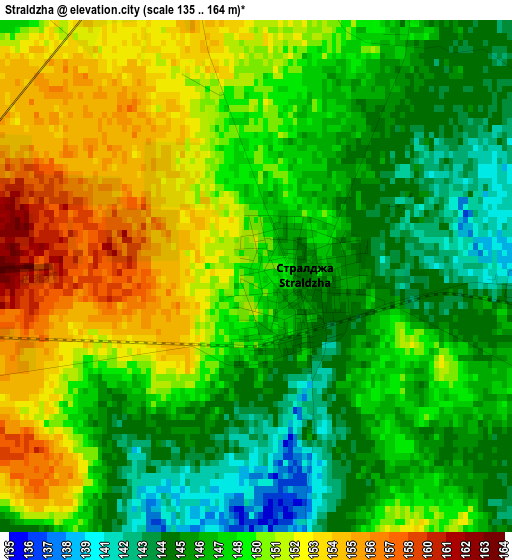
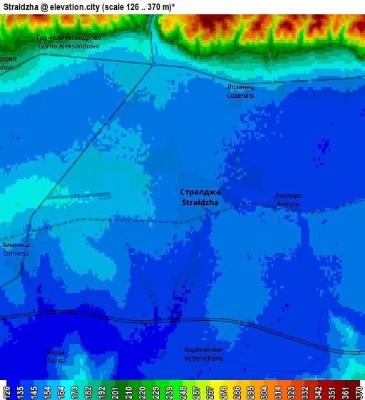
Below is the Elevation map of Straldzha, which displays elevation range with different colors. Scale of the first map is from 135 to 164 m (443 to 538 ft) with average elevation of 148.6 meters (=488 ft) [note 1]
These maps also provides idea of topography and contour of this city, they are displayed at different zoom levels. More info about maps, scale and edge coordinates you can find below images.
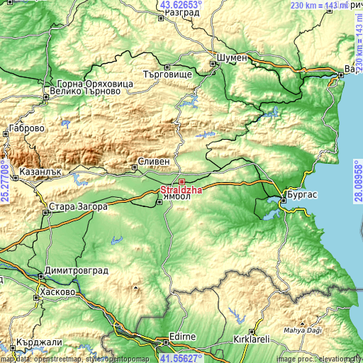
| \ | Map #1 | Map #2 | Topo.Map |
| Scale [m] | 135..164 m | 126..370 m | × |
| Scale [ft] | 443..538 ft | 413..1214 ft | × |
| Average | 148.6 m = 488 ft | 158.9 m = 521 ft | × |
| Width | 7.19 km = 4.5 mi | 14.39 km = 8.9 mi | 230.2 km = 143 mi |
| Height | 7.19 km = 4.5 mi | 14.39 km = 8.9 mi | 230.2 km = 143 mi |
| ↑Max Latitude | 42.63234° | 42.664662° | 43.62653° |
| Latitude at center | 42.6° | 42.6° | 42.6° |
| ↓Min Latitude | 42.567644° | 42.53527° | 41.55627° |
| ← Min Longitude | 26.639385° | 26.595439° | 25.27708° |
| Longitude center | 26.68333° | 26.68333° | 26.68333° |
| →Max Longitude | 26.727275° | 26.771221° | 28.08958° |
Nearby cities:
Cities around Straldzha sort by population:
• Sliven elevation 271 m
30.5 km,  288°
288°
• Yambol 132 m
19.8 km,  229°
229°
• Aytos 89 m
47.7 km,  76°
76°
• Karnobat 208 m
25.2 km, 77°
• Elhovo 118 m
49.1 km,  191°
191°
• Sredets 25 m
49.4 km,  124°
124°
• Kotel 494 m
36.8 km,  328°
328°
• Kameno 20 m
50.5 km,  93°
93°
• Sungurlare 206 m
20.3 km,  23°
23°
• Varbitsa 279 m
44.7 km,  354°
354°
• Kermen 169 m
37.2 km,  252°
252°
• Bolyarovo 190 m
51.2 km,  168°
168°
Multilingual:
 En español:
Straldzha elevación 149 m.
 En France:
Straldzha élévation 149 m.
 Auf Deutsch:
Straldzha höhe über dem Meeresspiegel ist 149 m.

Sources and notes:
- [note 1] Map square and city borders are not equal. Map elevation data is calculated only from area inside that square.
- [src 1] Elevation data from geonames database provided with same terms of usage.
- [src 2] The elevation map of Straldzha is generated using elevation data from NASA's 3 arcsec (90m) resolution SRTM data.
- [src 3] Base (background) map © OpenStreetMap contributors tiles are generated by Geofabrik and OpenTopoMap.
Copyright & License:
This Straldzha Elevation Map is licensed under CC BY-SA. You may reuse any part from this page, if you give a proper credit by linking to this URL:
 More info on terms of use page.