Bobo-Dioulasso elevation
Bobo-Dioulasso (Hauts-Bassins, Province du Houet), Burkina Faso elevation is 423 meters and Bobo-Dioulasso elevation in feet is 1388 ft above sea level [src 1]. Bobo-Dioulasso is a seat of a first-order administrative division (feature code) with elevation that is 119 meters (390 ft) bigger than average city elevation in Burkina Faso.
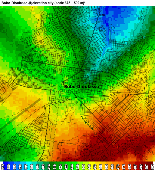
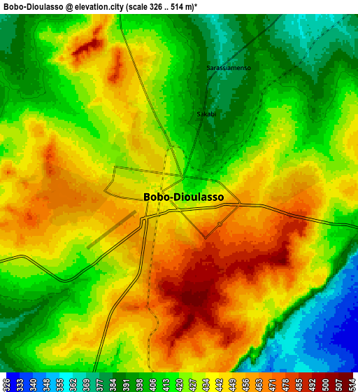
Below is the Elevation map of Bobo-Dioulasso, which displays elevation range with different colors. Scale of the first map is from 375 to 502 m (1230 to 1647 ft) with average elevation of 441.4 meters (=1448 ft) [note 1]
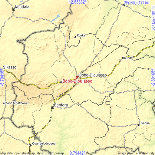
These maps also provides idea of topography and contour of this city, they are displayed at different zoom levels. More info about maps, scale and edge coordinates you can find below images.
| \ | Map #1 | Map #2 | Topo.Map |
| Scale [m] | 375..502 m | 326..514 m | × |
| Scale [ft] | 1230..1647 ft | 1070..1686 ft | × |
| Average | 441.4 m = 1448 ft | 426.2 m = 1398 ft | × |
| Width | 9.59 km = 6 mi | 19.17 km = 11.9 mi | 306.8 km = 190.6 mi |
| Height | 9.59 km = 6 mi | 19.17 km = 11.9 mi | 306.8 km = 190.6 mi |
| ↑Max Latitude | 11.220259° | 11.263361° | 12.55332° |
| Latitude at center | 11.17715° | 11.17715° | 11.17715° |
| ↓Min Latitude | 11.134035° | 11.090914° | 9.79442° |
| ← Min Longitude | -4.341845° | -4.385791° | -5.70415° |
| Longitude center | -4.2979° | -4.2979° | -4.2979° |
| →Max Longitude | -4.253955° | -4.210009° | -2.89165° |
Nearby cities:
Cities around Bobo-Dioulasso sort by population:
• Banfora elevation 299 m
79.2 km,  220°
220°
• Dédougou 302 m
169.6 km,  32°
32°
• Houndé 349 m
92.4 km,  67°
67°
• Nouna 277 m
179 km,  15°
15°
• Boromo 263 m
161.9 km, 67°
• Diébougou 290 m
116.9 km,  101°
101°
• Toma 287 m
232.5 km,  40°
40°
• Dano 285 m
135.3 km,  91°
91°
• Salanso 316 m
113.3 km,  11°
11°
• Batié 307 m
208.5 km,  133°
133°
• Barani 283 m
225.9 km, 11°
• Sindou 370 m
110.5 km,  239°
239°
Multilingual:
 En español:
Bobo-Dioulasso elevación 423 m.
 En France:
Bobo-Dioulasso élévation 423 m.
 Auf Deutsch:
Bobo-Dioulasso höhe über dem Meeresspiegel ist 423 m.

Sources and notes:
- [note 1] Map square and city borders are not equal. Map elevation data is calculated only from area inside that square.
- [src 1] Elevation data from geonames database provided with same terms of usage.
- [src 2] The elevation map of Bobo-Dioulasso is generated using elevation data from NASA's 3 arcsec (90m) resolution SRTM data.
- [src 3] Base (background) map © OpenStreetMap contributors tiles are generated by Geofabrik and OpenTopoMap.
Copyright & License:
This Bobo-Dioulasso Elevation Map is licensed under CC BY-SA. You may reuse any part from this page, if you give a proper credit by linking to this URL:
 More info on terms of use page.