Boussé elevation
Boussé (Plateau-Central, Province du Kourwéogo), Burkina Faso elevation is 319 meters and Boussé elevation in feet is 1047 ft above sea level [src 1]. Boussé is a seat of a second-order administrative division (feature code) with elevation that is 15 meters (49 ft) bigger than average city elevation in Burkina Faso.
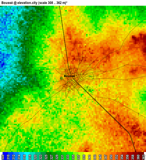
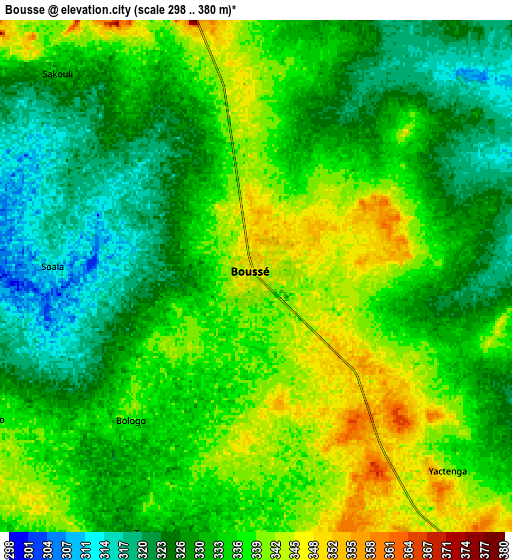
Below is the Elevation map of Boussé, which displays elevation range with different colors. Scale of the first map is from 308 to 362 m (1010 to 1188 ft) with average elevation of 338.5 meters (=1111 ft) [note 1]
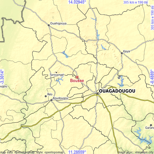
These maps also provides idea of topography and contour of this city, they are displayed at different zoom levels. More info about maps, scale and edge coordinates you can find below images.
| \ | Map #1 | Map #2 | Topo.Map |
| Scale [m] | 308..362 m | 298..380 m | × |
| Scale [ft] | 1010..1188 ft | 978..1247 ft | × |
| Average | 338.5 m = 1111 ft | 333 m = 1093 ft | × |
| Width | 9.53 km = 5.9 mi | 19.07 km = 11.8 mi | 305.1 km = 189.6 mi |
| Height | 9.53 km = 5.9 mi | 19.07 km = 11.8 mi | 305.1 km = 189.6 mi |
| ↑Max Latitude | 12.704083° | 12.746949° | 14.02945° |
| Latitude at center | 12.66121° | 12.66121° | 12.66121° |
| ↓Min Latitude | 12.61833° | 12.575442° | 11.28559° |
| ← Min Longitude | -1.939095° | -1.983041° | -3.3014° |
| Longitude center | -1.89515° | -1.89515° | -1.89515° |
| →Max Longitude | -1.851205° | -1.807259° | -0.4889° |
Nearby cities:
Cities around Boussé sort by population:
• Pitmoaga elevation 331 m
46.2 km,  178°
178°
• Goulouré 325 m
47.6 km,  185°
185°
• Tanghin-Dassouri 319 m
47.3 km,  155°
155°
• Ourgou-Manéga 307 m
44 km,  72°
72°
• Bingo 325 m
40.6 km,  170°
170°
• Dapélogo 295 m
38.7 km,  88°
88°
• Pabré 304 m
36.9 km,  114°
114°
• Sourgoubila 325 m
29.1 km, 160°
• Toéghin 306 m
25 km,  46°
46°
• Laye 336 m
19.3 km,  138°
138°
• Niou 315 m
12.8 km,  340°
340°
• Siglé 341 m
11.7 km, 176°
Multilingual:
 En español:
Boussé elevación 319 m.
 En France:
Boussé élévation 319 m.


Sources and notes:
- [note 1] Map square and city borders are not equal. Map elevation data is calculated only from area inside that square.
- [src 1] Elevation data from geonames database provided with same terms of usage.
- [src 2] The elevation map of Boussé is generated using elevation data from NASA's 3 arcsec (90m) resolution SRTM data.
- [src 3] Base (background) map © OpenStreetMap contributors tiles are generated by Geofabrik and OpenTopoMap.
Copyright & License:
This Boussé Elevation Map is licensed under CC BY-SA. You may reuse any part from this page, if you give a proper credit by linking to this URL:
 More info on terms of use page.