Pitmoaga elevation
Pitmoaga (Centre-Ouest, Province du Boulkiemdé), Burkina Faso elevation is 331 meters and Pitmoaga elevation in feet is 1086 ft above sea level [src 1]. Pitmoaga is a populated place (feature code) with elevation that is 27 meters (89 ft) bigger than average city elevation in Burkina Faso.
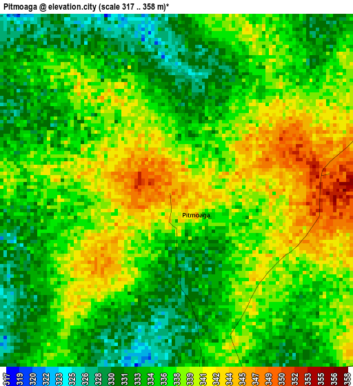
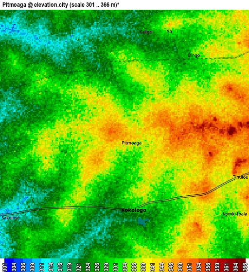
Below is the Elevation map of Pitmoaga, which displays elevation range with different colors. Scale of the first map is from 317 to 358 m (1040 to 1175 ft) with average elevation of 336.5 meters (=1104 ft) [note 1]
These maps also provides idea of topography and contour of this city, they are displayed at different zoom levels. More info about maps, scale and edge coordinates you can find below images.
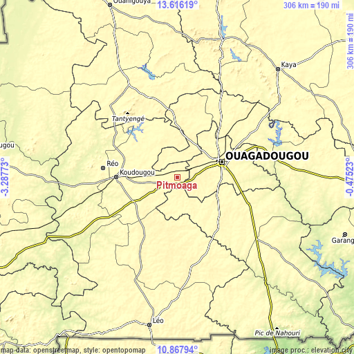
| \ | Map #1 | Map #2 | Topo.Map |
| Scale [m] | 317..358 m | 301..366 m | × |
| Scale [ft] | 1040..1175 ft | 988..1201 ft | × |
| Average | 336.5 m = 1104 ft | 331.6 m = 1088 ft | × |
| Width | 9.55 km = 5.9 mi | 19.1 km = 11.9 mi | 305.6 km = 189.9 mi |
| Height | 9.55 km = 5.9 mi | 19.1 km = 11.9 mi | 305.6 km = 189.9 mi |
| ↑Max Latitude | 12.288582° | 12.331517° | 13.61619° |
| Latitude at center | 12.24564° | 12.24564° | 12.24564° |
| ↓Min Latitude | 12.202691° | 12.159735° | 10.86794° |
| ← Min Longitude | -1.925425° | -1.969371° | -3.28773° |
| Longitude center | -1.88148° | -1.88148° | -1.88148° |
| →Max Longitude | -1.837535° | -1.793589° | -0.47523° |
Nearby cities:
Cities around Pitmoaga sort by population:
• Ouagadougou elevation 299 m
40.1 km,  70°
70°
• Kokologo 342 m
5.8 km,  175°
175°
• Goulouré 325 m
5.8 km,  258°
258°
• Saponé 305 m
36.9 km,  125°
125°
• Siglé 341 m
34.5 km,  358°
358°
• Laye 336 m
33.7 km,  19°
19°
• Komsilga 305 m
27.7 km,  103°
103°
• Kayao 317 m
26.2 km,  170°
170°
• Sourgoubila 325 m
20.5 km, 23°
• Tanghin-Dassouri 319 m
18.1 km,  80°
80°
• Komki-Ipala 315 m
12 km, 125°
• Bingo 325 m
8 km,  39°
39°
Multilingual:
 En español:
Pitmoaga elevación 331 m.
 En France:
Pitmoaga élévation 331 m.
 Auf Deutsch:
Pitmoaga höhe über dem Meeresspiegel ist 331 m.

Sources and notes:
- [note 1] Map square and city borders are not equal. Map elevation data is calculated only from area inside that square.
- [src 1] Elevation data from geonames database provided with same terms of usage.
- [src 2] The elevation map of Pitmoaga is generated using elevation data from NASA's 3 arcsec (90m) resolution SRTM data.
- [src 3] Base (background) map © OpenStreetMap contributors tiles are generated by Geofabrik and OpenTopoMap.
Copyright & License:
This Pitmoaga Elevation Map is licensed under CC BY-SA. You may reuse any part from this page, if you give a proper credit by linking to this URL:
 More info on terms of use page.