Kombissiri elevation
Kombissiri (Centre-Sud, Bazega Province), Burkina Faso elevation is 304 meters and Kombissiri elevation in feet is 997 ft above sea level [src 1]. Kombissiri is a seat of a second-order administrative division (feature code) with elevation that is 0 meters (0 ft) bigger than average city elevation in Burkina Faso.
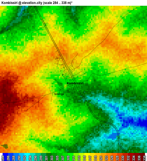
Below is the Elevation map of Kombissiri, which displays elevation range with different colors. Scale of the first map is from 284 to 338 m (932 to 1109 ft) with average elevation of 312.1 meters (=1024 ft) [note 1]
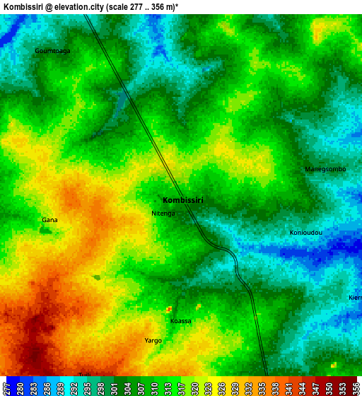
These maps also provides idea of topography and contour of this city, they are displayed at different zoom levels. More info about maps, scale and edge coordinates you can find below images.
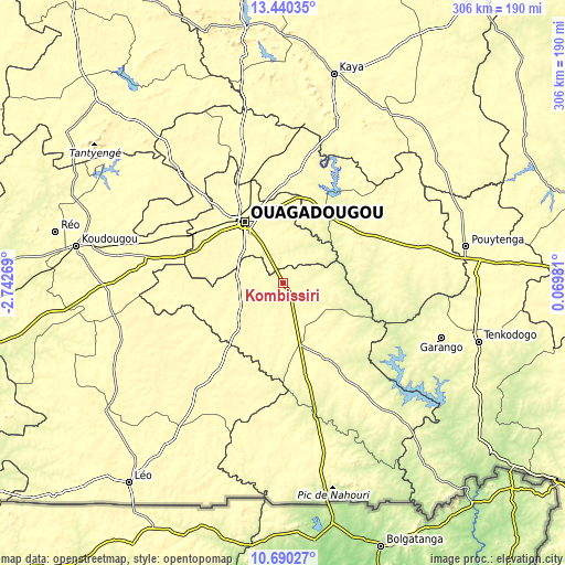
| \ | Map #1 | Map #2 | Topo.Map |
| Scale [m] | 284..338 m | 277..356 m | × |
| Scale [ft] | 932..1109 ft | 909..1168 ft | × |
| Average | 312.1 m = 1024 ft | 310.9 m = 1020 ft | × |
| Width | 9.56 km = 5.9 mi | 19.11 km = 11.9 mi | 305.8 km = 190 mi |
| Height | 9.56 km = 5.9 mi | 19.11 km = 11.9 mi | 305.8 km = 190 mi |
| ↑Max Latitude | 12.111811° | 12.154774° | 13.44035° |
| Latitude at center | 12.06884° | 12.06884° | 12.06884° |
| ↓Min Latitude | 12.025863° | 11.982878° | 10.69027° |
| ← Min Longitude | -1.380385° | -1.424331° | -2.74269° |
| Longitude center | -1.33644° | -1.33644° | -1.33644° |
| →Max Longitude | -1.292495° | -1.248549° | 0.06981° |
Nearby cities:
Cities around Kombissiri sort by population:
• Ouagadougou elevation 299 m
39.4 km,  326°
326°
• Manga 286 m
53.4 km,  147°
147°
• Kayao 317 m
55.3 km,  263°
263°
• Komki-Ipala 315 m
51 km,  284°
284°
• Loumbila 295 m
50.2 km,  355°
355°
• Nagréongo 270 m
47.9 km,  17°
17°
• Tanghin-Dassouri 319 m
47.2 km,  298°
298°
• Komsilga 305 m
34.9 km,  292°
292°
• Saaba 297 m
34.7 km,  345°
345°
• Saponé 305 m
29.2 km,  266°
266°
• Gaongo 306 m
20 km,  111°
111°
• Koubri 290 m
16.2 km, 331°
Multilingual:
 En español:
Kombissiri elevación 304 m.
 En France:
Kombissiri élévation 304 m.
 Auf Deutsch:
Kombissiri höhe über dem Meeresspiegel ist 304 m.

Sources and notes:
- [note 1] Map square and city borders are not equal. Map elevation data is calculated only from area inside that square.
- [src 1] Elevation data from geonames database provided with same terms of usage.
- [src 2] The elevation map of Kombissiri is generated using elevation data from NASA's 3 arcsec (90m) resolution SRTM data.
- [src 3] Base (background) map © OpenStreetMap contributors tiles are generated by Geofabrik and OpenTopoMap.
Copyright & License:
This Kombissiri Elevation Map is licensed under CC BY-SA. You may reuse any part from this page, if you give a proper credit by linking to this URL:
 More info on terms of use page.