Tougan elevation
Tougan (Boucle du Mouhoun, Province du Sourou), Burkina Faso elevation is 300 meters and Tougan elevation in feet is 984 ft above sea level [src 1]. Tougan is a seat of a second-order administrative division (feature code) with elevation that is 4 meters (13 ft) smaller than average city elevation in Burkina Faso.
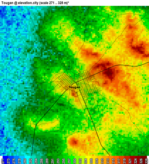
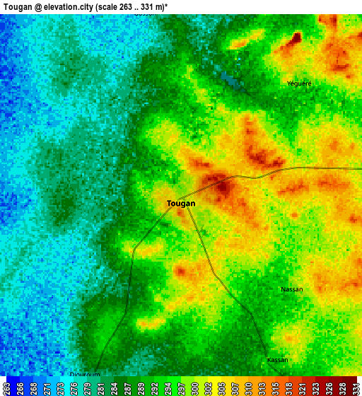
Below is the Elevation map of Tougan, which displays elevation range with different colors. Scale of the first map is from 271 to 328 m (889 to 1076 ft) with average elevation of 296.9 meters (=974 ft) [note 1]
These maps also provides idea of topography and contour of this city, they are displayed at different zoom levels. More info about maps, scale and edge coordinates you can find below images.
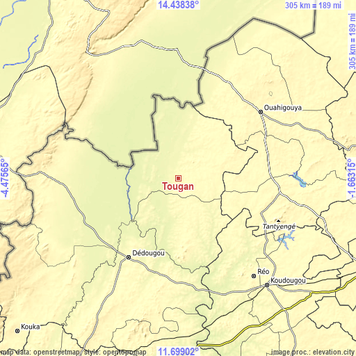
| \ | Map #1 | Map #2 | Topo.Map |
| Scale [m] | 271..328 m | 263..331 m | × |
| Scale [ft] | 889..1076 ft | 863..1086 ft | × |
| Average | 296.9 m = 974 ft | 290.3 m = 952 ft | × |
| Width | 9.52 km = 5.9 mi | 19.04 km = 11.8 mi | 304.6 km = 189.3 mi |
| Height | 9.52 km = 5.9 mi | 19.04 km = 11.8 mi | 304.6 km = 189.3 mi |
| ↑Max Latitude | 13.115303° | 13.158098° | 14.43838° |
| Latitude at center | 13.0725° | 13.0725° | 13.0725° |
| ↓Min Latitude | 13.02969° | 12.986872° | 11.69902° |
| ← Min Longitude | -3.113345° | -3.157291° | -4.47565° |
| Longitude center | -3.0694° | -3.0694° | -3.0694° |
| →Max Longitude | -3.025455° | -2.981509° | -1.66315° |
Nearby cities:
Cities around Tougan sort by population:
• Koudougou elevation 303 m
119.1 km,  139°
139°
• Ouahigouya 328 m
90.2 km,  51°
51°
• Dédougou 302 m
79.9 km,  212°
212°
• Réo 300 m
105.9 km, 142°
• Nouna 277 m
94.1 km,  246°
246°
• Yako 332 m
88.5 km,  98°
98°
• Titao 326 m
133.1 km, 54°
• Gourcy 331 m
78.4 km,  78°
78°
• Boussé 319 m
135.3 km,  109°
109°
• Toma 287 m
39.5 km,  152°
152°
• Barani 283 m
89.5 km,  276°
276°
• Niou 315 m
127.6 km, 105°
Multilingual:
 En español:
Tougan elevación 300 m.
 En France:
Tougan élévation 300 m.


Sources and notes:
- [note 1] Map square and city borders are not equal. Map elevation data is calculated only from area inside that square.
- [src 1] Elevation data from geonames database provided with same terms of usage.
- [src 2] The elevation map of Tougan is generated using elevation data from NASA's 3 arcsec (90m) resolution SRTM data.
- [src 3] Base (background) map © OpenStreetMap contributors tiles are generated by Geofabrik and OpenTopoMap.
Copyright & License:
This Tougan Elevation Map is licensed under CC BY-SA. You may reuse any part from this page, if you give a proper credit by linking to this URL:
 More info on terms of use page.