Galmaarden elevation
Galmaarden (Flanders, Provincie Vlaams-Brabant), Belgium elevation is 32 meters and Galmaarden elevation in feet is 105 ft above sea level [src 1]. Galmaarden is a populated place (feature code) with elevation that is 67 meters (220 ft) smaller than average city elevation in Belgium.
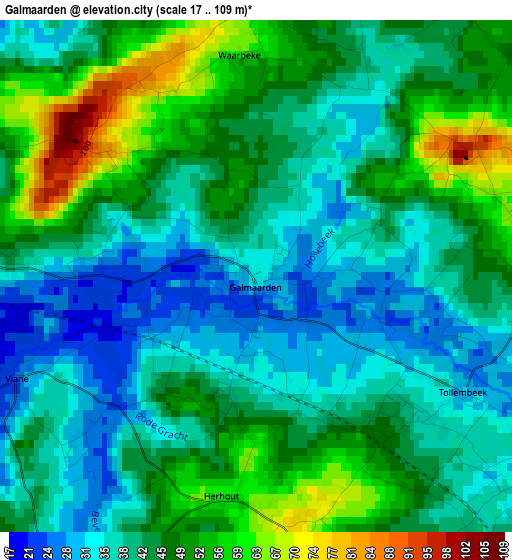
Below is the Elevation map of Galmaarden, which displays elevation range with different colors. Scale of the first map is from 17 to 109 m (56 to 358 ft) with average elevation of 43.4 meters (=142 ft) [note 1]
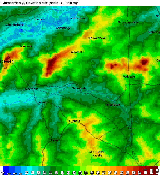
These maps also provides idea of topography and contour of this city, they are displayed at different zoom levels. More info about maps, scale and edge coordinates you can find below images.
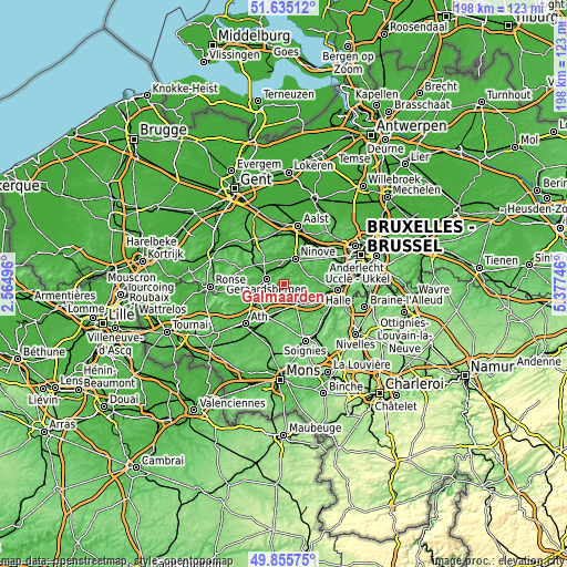
| \ | Map #1 | Map #2 | Topo.Map |
| Scale [m] | 17..109 m | -4..110 m | × |
| Scale [ft] | 56..358 ft | -13..361 ft | × |
| Average | 43.4 m = 142 ft | 41.4 m = 136 ft | × |
| Width | 6.18 km = 3.8 mi | 12.37 km = 7.7 mi | 197.8 km = 122.9 mi |
| Height | 6.18 km = 3.8 mi | 12.37 km = 7.7 mi | 197.8 km = 122.9 mi |
| ↑Max Latitude | 50.781684° | 50.809461° | 51.63512° |
| Latitude at center | 50.75389° | 50.75389° | 50.75389° |
| ↓Min Latitude | 50.72608° | 50.698253° | 49.85575° |
| ← Min Longitude | 3.927265° | 3.883319° | 2.56496° |
| Longitude center | 3.97121° | 3.97121° | 3.97121° |
| →Max Longitude | 4.015155° | 4.059101° | 5.37746° |
Nearby cities:
Cities around Galmaarden sort by population:
• Ninove elevation 17 m
9.1 km,  25°
25°
• Geraardsbergen 32 m
6.6 km,  289°
289°
• Lessines 23 m
10.7 km,  243°
243°
• Liedekerke 24 m
15.2 km, 32°
• Enghien 58 m
8.9 km,  150°
150°
• Rebecq-Rognon 65 m
14.9 km,  140°
140°
• Gooik 39 m
11 km,  65°
65°
• Silly 59 m
12.2 km,  195°
195°
• Herne 43 m
5.6 km,  126°
126°
• Sint-Maria-Lierde 45 m
11.5 km,  308°
308°
• Pepingen 52 m
13.3 km,  87°
87°
• Ledeberg 61 m
13.1 km,  40°
40°
Multilingual:
 En español:
Galmaarden elevación 32 m.
 En France:
Galmaarden élévation 32 m.
 Auf Deutsch:
Galmaarden höhe über dem Meeresspiegel ist 32 m.

Sources and notes:
- [note 1] Map square and city borders are not equal. Map elevation data is calculated only from area inside that square.
- [src 1] Elevation data from geonames database provided with same terms of usage.
- [src 2] The elevation map of Galmaarden is generated using elevation data from NASA's 3 arcsec (90m) resolution SRTM data.
- [src 3] Base (background) map © OpenStreetMap contributors tiles are generated by Geofabrik and OpenTopoMap.
Copyright & License:
This Galmaarden Elevation Map is licensed under CC BY-SA. You may reuse any part from this page, if you give a proper credit by linking to this URL:
 More info on terms of use page.