Hensies elevation
Hensies (Wallonia, Province du Hainaut), Belgium elevation is 19 meters and Hensies elevation in feet is 62 ft above sea level [src 1]. Hensies is a populated place (feature code) with elevation that is 80 meters (262 ft) smaller than average city elevation in Belgium.
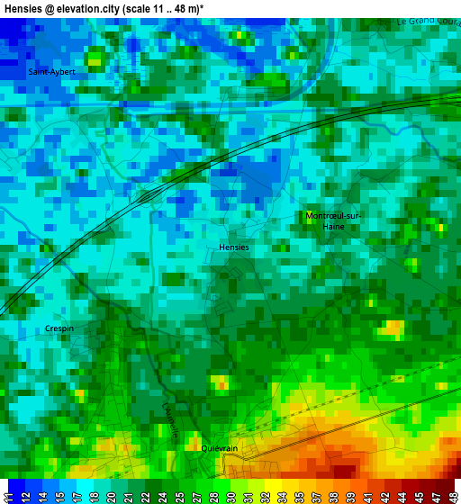
Below is the Elevation map of Hensies, which displays elevation range with different colors. Scale of the first map is from 11 to 48 m (36 to 157 ft) with average elevation of 21.7 meters (=71 ft) [note 1]
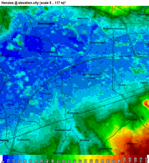
These maps also provides idea of topography and contour of this city, they are displayed at different zoom levels. More info about maps, scale and edge coordinates you can find below images.
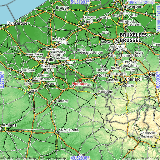
| \ | Map #1 | Map #2 | Topo.Map |
| Scale [m] | 11..48 m | 9..117 m | × |
| Scale [ft] | 36..157 ft | 30..384 ft | × |
| Average | 21.7 m = 71 ft | 30.5 m = 100 ft | × |
| Width | 6.22 km = 3.9 mi | 12.45 km = 7.7 mi | 199.2 km = 123.8 mi |
| Height | 6.22 km = 3.9 mi | 12.45 km = 7.7 mi | 199.2 km = 123.8 mi |
| ↑Max Latitude | 50.460614° | 50.488582° | 51.31993° |
| Latitude at center | 50.43263° | 50.43263° | 50.43263° |
| ↓Min Latitude | 50.404629° | 50.376612° | 49.52838° |
| ← Min Longitude | 3.640165° | 3.596219° | 2.27786° |
| Longitude center | 3.68411° | 3.68411° | 3.68411° |
| →Max Longitude | 3.728055° | 3.772001° | 5.09036° |
Nearby cities:
Cities around Hensies sort by population:
• Mons elevation 56 m
19.1 km,  82°
82°
• Saint-Ghislain 27 m
9.7 km, 79°
• Frameries 113 m
15.3 km,  101°
101°
• Boussu 32 m
7.8 km,  88°
88°
• Colfontaine 79 m
12.3 km, 99°
• Quaregnon 35 m
12.9 km, 86°
• Dour 93 m
7.8 km,  121°
121°
• Péruwelz 34 m
10.6 km,  322°
322°
• Beloeil 59 m
13.6 km,  15°
15°
• Bernissart 20 m
5.3 km,  332°
332°
• Quiévrain 35 m
2.8 km,  180°
180°
• Chasse Royale 42 m
18.8 km, 91°
Multilingual:
 En español:
Hensies elevación 19 m.
 En France:
Hensies élévation 19 m.


Sources and notes:
- [note 1] Map square and city borders are not equal. Map elevation data is calculated only from area inside that square.
- [src 1] Elevation data from geonames database provided with same terms of usage.
- [src 2] The elevation map of Hensies is generated using elevation data from NASA's 3 arcsec (90m) resolution SRTM data.
- [src 3] Base (background) map © OpenStreetMap contributors tiles are generated by Geofabrik and OpenTopoMap.
Copyright & License:
This Hensies Elevation Map is licensed under CC BY-SA. You may reuse any part from this page, if you give a proper credit by linking to this URL:
 More info on terms of use page.