Lanaken elevation
Lanaken (Flanders, Provincie Limburg), Belgium elevation is 63 meters and Lanaken elevation in feet is 207 ft above sea level [src 1]. Lanaken is a populated place (feature code) with elevation that is 36 meters (118 ft) smaller than average city elevation in Belgium.
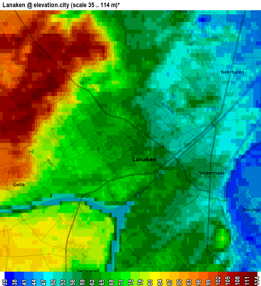
Below is the Elevation map of Lanaken, which displays elevation range with different colors. Scale of the first map is from 35 to 114 m (115 to 374 ft) with average elevation of 67.8 meters (=222 ft) [note 1]
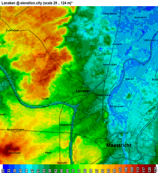
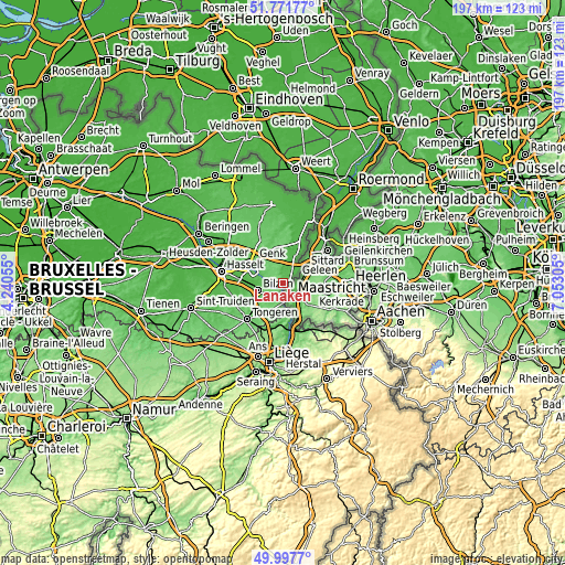
These maps also provides idea of topography and contour of this city, they are displayed at different zoom levels. More info about maps, scale and edge coordinates you can find below images.
| \ | Map #1 | Map #2 | Topo.Map |
| Scale [m] | 35..114 m | 29..124 m | × |
| Scale [ft] | 115..374 ft | 95..407 ft | × |
| Average | 67.8 m = 222 ft | 67.3 m = 221 ft | × |
| Width | 6.16 km = 3.8 mi | 12.33 km = 7.7 mi | 197.3 km = 122.6 mi |
| Height | 6.16 km = 3.8 mi | 12.33 km = 7.7 mi | 197.2 km = 122.5 mi |
| ↑Max Latitude | 50.920891° | 50.948586° | 51.77177° |
| Latitude at center | 50.89318° | 50.89318° | 50.89318° |
| ↓Min Latitude | 50.865452° | 50.837708° | 49.9977° |
| ← Min Longitude | 5.602855° | 5.558909° | 4.24055° |
| Longitude center | 5.6468° | 5.6468° | 5.6468° |
| →Max Longitude | 5.690745° | 5.734691° | 7.05305° |
Nearby cities:
Cities around Lanaken sort by population:
• Genk elevation 66 m
13 km,  307°
307°
• Maasmechelen 39 m
8.7 km,  22°
22°
• Tongeren 107 m
17.9 km,  225°
225°
• Bilzen 53 m
9.3 km,  256°
256°
• Diepenbeek 50 m
16.1 km,  275°
275°
• Visé 86 m
17.7 km,  168°
168°
• Riemst 105 m
9.8 km,  199°
199°
• Opglabbeek 72 m
17.2 km,  345°
345°
• Hoeselt 77 m
12.3 km,  245°
245°
• Bassenge 75 m
15.2 km,  189°
189°
• As 81 m
13.4 km,  341°
341°
• Zutendaal 84 m
6.7 km, 311°
Multilingual:
 En español:
Lanaken elevación 63 m.
 En France:
Lanaken élévation 63 m.


Sources and notes:
- [note 1] Map square and city borders are not equal. Map elevation data is calculated only from area inside that square.
- [src 1] Elevation data from geonames database provided with same terms of usage.
- [src 2] The elevation map of Lanaken is generated using elevation data from NASA's 3 arcsec (90m) resolution SRTM data.
- [src 3] Base (background) map © OpenStreetMap contributors tiles are generated by Geofabrik and OpenTopoMap.
Copyright & License:
This Lanaken Elevation Map is licensed under CC BY-SA. You may reuse any part from this page, if you give a proper credit by linking to this URL:
 More info on terms of use page.