Oudenaarde elevation
Oudenaarde (Flanders, Provincie Oost-Vlaanderen), Belgium elevation is 11 meters and Oudenaarde elevation in feet is 36 ft above sea level [src 1]. Oudenaarde is a seat of a third-order administrative division (feature code) with elevation that is 88 meters (289 ft) smaller than average city elevation in Belgium.
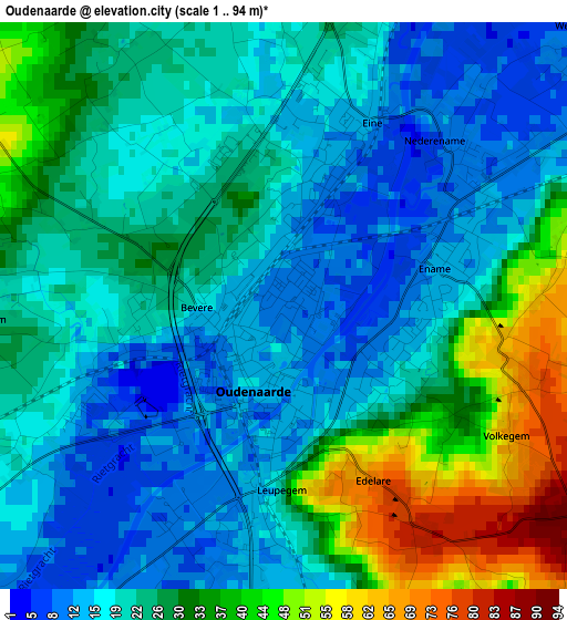
Below is the Elevation map of Oudenaarde, which displays elevation range with different colors. Scale of the first map is from 1 to 94 m (3 to 308 ft) with average elevation of 24.9 meters (=82 ft) [note 1]
These maps also provides idea of topography and contour of this city, they are displayed at different zoom levels. More info about maps, scale and edge coordinates you can find below images.
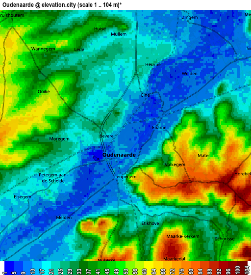
| \ | Map #1 | Map #2 | Topo.Map |
| Scale [m] | 1..94 m | 1..104 m | × |
| Scale [ft] | 3..308 ft | 3..341 ft | × |
| Average | 24.9 m = 82 ft | 32.7 m = 107 ft | × |
| Width | 6.17 km = 3.8 mi | 12.34 km = 7.7 mi | 197.4 km = 122.7 mi |
| Height | 6.17 km = 3.8 mi | 12.34 km = 7.7 mi | 197.4 km = 122.7 mi |
| ↑Max Latitude | 50.879416° | 50.907135° | 51.73106° |
| Latitude at center | 50.85168° | 50.85168° | 50.85168° |
| ↓Min Latitude | 50.823928° | 50.796159° | 49.95541° |
| ← Min Longitude | 3.564965° | 3.521019° | 2.20266° |
| Longitude center | 3.60891° | 3.60891° | 3.60891° |
| →Max Longitude | 3.652855° | 3.696801° | 5.01516° |
Nearby cities:
Cities around Oudenaarde sort by population:
• Waregem elevation 13 m
13.4 km,  288°
288°
• Deinze 10 m
15.5 km,  339°
339°
• Zottegem 63 m
14.3 km,  82°
82°
• Ronse 42 m
11.8 km,  182°
182°
• Zulte 11 m
13.5 km,  303°
303°
• Anzegem 51 m
9.3 km,  259°
259°
• Gavere 25 m
9.4 km,  23°
23°
• Nazareth 12 m
11.7 km,  354°
354°
• Avelgem 17 m
14.2 km,  233°
233°
• Kruishoutem 45 m
8.1 km,  313°
313°
• Zingem 16 m
6.6 km,  27°
27°
• Ellezelles 56 m
13.9 km,  158°
158°
Multilingual:
 En español:
Oudenaarde elevación 11 m.
 En France:
Audenarde élévation 11 m.
 Auf Deutsch:
Oudenaarde höhe über dem Meeresspiegel ist 11 m.
 На русском:
Оуденаарде, Ауденарде высота над уровнем моря 11 м
Sources and notes:
- [note 1] Map square and city borders are not equal. Map elevation data is calculated only from area inside that square.
- [src 1] Elevation data from geonames database provided with same terms of usage.
- [src 2] The elevation map of Oudenaarde is generated using elevation data from NASA's 3 arcsec (90m) resolution SRTM data.
- [src 3] Base (background) map © OpenStreetMap contributors tiles are generated by Geofabrik and OpenTopoMap.
Copyright & License:
This Oudenaarde Elevation Map is licensed under CC BY-SA. You may reuse any part from this page, if you give a proper credit by linking to this URL:
 More info on terms of use page.