Trois-Ponts elevation
Trois-Ponts (Wallonia, Province de Liège), Belgium elevation is 253 meters and Trois-Ponts elevation in feet is 830 ft above sea level [src 1]. Trois-Ponts is a populated place (feature code) with elevation that is 154 meters (505 ft) bigger than average city elevation in Belgium.
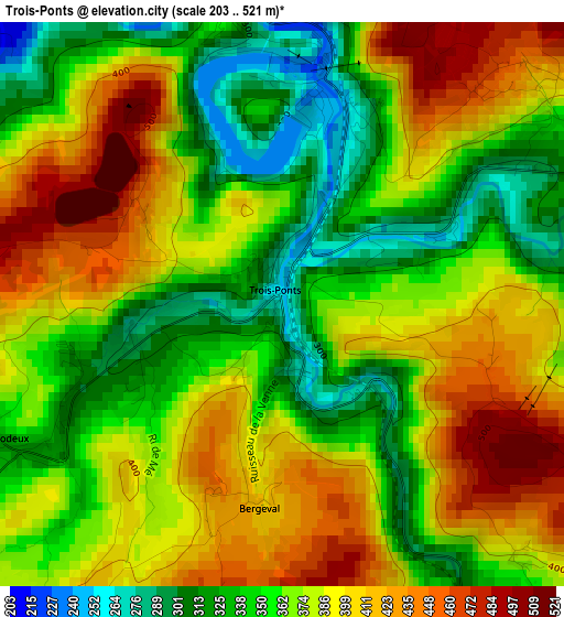
Below is the Elevation map of Trois-Ponts, which displays elevation range with different colors. Scale of the first map is from 203 to 521 m (666 to 1709 ft) with average elevation of 374.4 meters (=1228 ft) [note 1]
These maps also provides idea of topography and contour of this city, they are displayed at different zoom levels. More info about maps, scale and edge coordinates you can find below images.
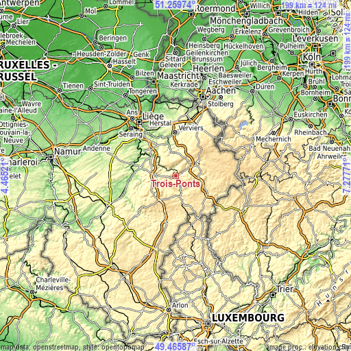
| \ | Map #1 | Topo.Map |
| Scale [m] | 203..521 m | × |
| Scale [ft] | 666..1709 ft | × |
| Average | 374.4 m = 1228 ft | × |
| Width | 6.23 km = 3.9 mi | 199.5 km = 124 mi |
| Height | 6.23 km = 3.9 mi | 199.4 km = 123.9 mi |
| ↑Max Latitude | 50.3993° | 51.25974° |
| Latitude at center | 50.37128° | 50.37128° |
| ↓Min Latitude | 50.343243° | 49.46587° |
| ← Min Longitude | 5.827515° | 4.46521° |
| Longitude center | 5.87146° | 5.87146° |
| →Max Longitude | 5.915405° | 7.27771° |
Nearby cities:
Cities around Trois-Ponts sort by population:
• Theux elevation 168 m
18.5 km,  346°
346°
• Malmédy 344 m
12.7 km,  60°
60°
• Spa 312 m
12.5 km,  358°
358°
• Aywaille 124 m
17.9 km,  309°
309°
• Saint-Vith 474 m
20.7 km,  118°
118°
• Vielsalm 367 m
10.2 km,  162°
162°
• Waimes 492 m
17.7 km,  74°
74°
• Stavelot 297 m
5 km, 58°
• Ferrières 225 m
18.8 km,  280°
280°
• Lierneux 418 m
11.1 km,  210°
210°
• Manhay 440 m
16.4 km,  237°
237°
• Stoumont 335 m
6 km, 311°
Multilingual:
 En español:
Trois-Ponts elevación 253 m.
 En France:
Trois-Ponts élévation 253 m.
 Auf Deutsch:
Trois-Ponts höhe über dem Meeresspiegel ist 253 m.

Sources and notes:
- [note 1] Map square and city borders are not equal. Map elevation data is calculated only from area inside that square.
- [src 1] Elevation data from geonames database provided with same terms of usage.
- [src 2] The elevation map of Trois-Ponts is generated using elevation data from NASA's 3 arcsec (90m) resolution SRTM data.
- [src 3] Base (background) map © OpenStreetMap contributors tiles are generated by Geofabrik and OpenTopoMap.
Copyright & License:
This Trois-Ponts Elevation Map is licensed under CC BY-SA. You may reuse any part from this page, if you give a proper credit by linking to this URL:
 More info on terms of use page.