Bileća elevation
Bileća (Srpska, Opština Bileća), Bosnia and Herzegovina elevation is 468 meters and Bileća elevation in feet is 1535 ft above sea level [src 1]. Bileća is a seat of a second-order administrative division (feature code) with elevation that is 105 meters (344 ft) bigger than average city elevation in Bosnia and Herzegovina.
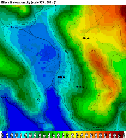
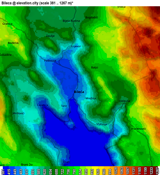
Below is the Elevation map of Bileća, which displays elevation range with different colors. Scale of the first map is from 383 to 984 m (1257 to 3228 ft) with average elevation of 579.4 meters (=1901 ft) [note 1]
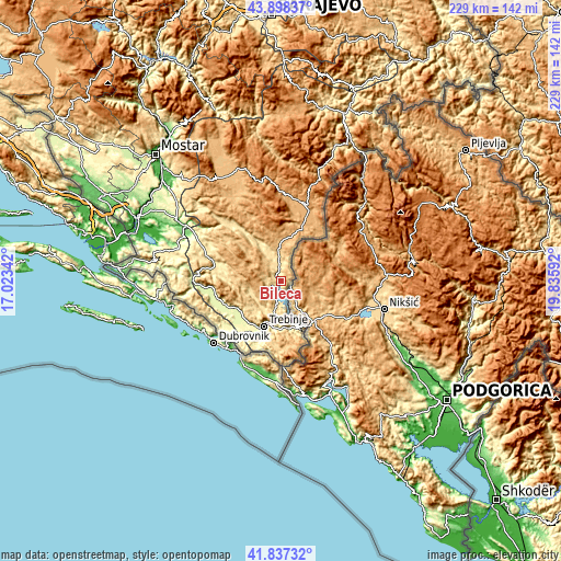
These maps also provides idea of topography and contour of this city, they are displayed at different zoom levels. More info about maps, scale and edge coordinates you can find below images.
| \ | Map #1 | Map #2 | Topo.Map |
| Scale [m] | 383..984 m | 381..1267 m | × |
| Scale [ft] | 1257..3228 ft | 1250..4157 ft | × |
| Average | 579.4 m = 1901 ft | 699.5 m = 2295 ft | × |
| Width | 7.16 km = 4.4 mi | 14.32 km = 8.9 mi | 229.2 km = 142.4 mi |
| Height | 7.16 km = 4.4 mi | 14.32 km = 8.9 mi | 229.2 km = 142.4 mi |
| ↑Max Latitude | 42.908646° | 42.940825° | 43.89837° |
| Latitude at center | 42.87645° | 42.87645° | 42.87645° |
| ↓Min Latitude | 42.844237° | 42.812008° | 41.83732° |
| ← Min Longitude | 18.385725° | 18.341779° | 17.02342° |
| Longitude center | 18.42967° | 18.42967° | 18.42967° |
| →Max Longitude | 18.473615° | 18.517561° | 19.83592° |
Nearby cities:
Cities around Bileća sort by population:
• Trebinje elevation 278 m
19.6 km,  201°
201°
• Čapljina 38 m
66.4 km,  294°
294°
• Stolac 61 m
44.6 km,  301°
301°
• Nevesinje 891 m
49.7 km,  328°
328°
• Crnići 239 m
54 km, 301°
• Blagaj 62 m
61.2 km,  314°
314°
• Ljubinje 406 m
29.1 km, 286°
• Neum 70 m
66.5 km,  274°
274°
• Gacko 970 m
33.5 km,  14°
14°
• Tasovčići 17 m
63.4 km, 294°
• Ravno 370 m
37.8 km, 271°
• Berkovići 544 m
32.2 km,  318°
318°
Multilingual:
 En español:
Bileća elevación 468 m.
 En France:
Bileća élévation 468 m.


Sources and notes:
- [note 1] Map square and city borders are not equal. Map elevation data is calculated only from area inside that square.
- [src 1] Elevation data from geonames database provided with same terms of usage.
- [src 2] The elevation map of Bileća is generated using elevation data from NASA's 3 arcsec (90m) resolution SRTM data.
- [src 3] Base (background) map © OpenStreetMap contributors tiles are generated by Geofabrik and OpenTopoMap.
Copyright & License:
This Bileća Elevation Map is licensed under CC BY-SA. You may reuse any part from this page, if you give a proper credit by linking to this URL:
 More info on terms of use page.