Gromiljak elevation
Gromiljak (Federation of B&H), Bosnia and Herzegovina elevation is 481 meters and Gromiljak elevation in feet is 1578 ft above sea level [src 1]. Gromiljak is a populated place (feature code) with elevation that is 118 meters (387 ft) bigger than average city elevation in Bosnia and Herzegovina.
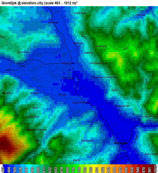
Below is the Elevation map of Gromiljak, which displays elevation range with different colors. Scale of the first map is from 463 to 1012 m (1519 to 3320 ft) with average elevation of 575 meters (=1886 ft) [note 1]
These maps also provides idea of topography and contour of this city, they are displayed at different zoom levels. More info about maps, scale and edge coordinates you can find below images.
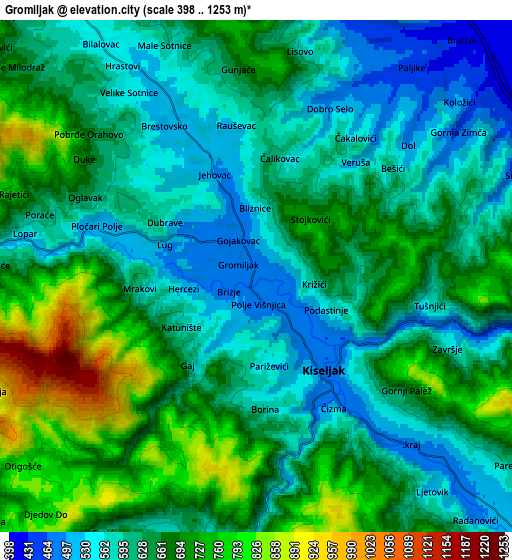
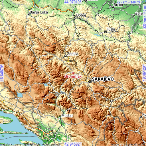
| \ | Map #1 | Map #2 | Topo.Map |
| Scale [m] | 463..1012 m | 398..1253 m | × |
| Scale [ft] | 1519..3320 ft | 1306..4111 ft | × |
| Average | 575 m = 1886 ft | 641.8 m = 2106 ft | × |
| Width | 7.03 km = 4.4 mi | 14.07 km = 8.7 mi | 225.1 km = 139.9 mi |
| Height | 7.03 km = 4.4 mi | 14.07 km = 8.7 mi | 225.1 km = 139.9 mi |
| ↑Max Latitude | 43.998301° | 44.029905° | 44.97019° |
| Latitude at center | 43.96668° | 43.96668° | 43.96668° |
| ↓Min Latitude | 43.935042° | 43.903388° | 42.94592° |
| ← Min Longitude | 18.011095° | 17.967149° | 16.64879° |
| Longitude center | 18.05504° | 18.05504° | 18.05504° |
| →Max Longitude | 18.098985° | 18.142931° | 19.46129° |
Nearby cities:
Cities around Gromiljak sort by population:
• Visoko elevation 423 m
10.1 km,  75°
75°
• Kiseljak 471 m
3.4 km,  141°
141°
• Fojnica 578 m
12.2 km,  266°
266°
• Ilijaš 463 m
17.4 km,  95°
95°
• Mahala 485 m
16.8 km,  72°
72°
• Kačuni 442 m
14.3 km,  319°
319°
• Gornje Moštre 410 m
9.9 km,  53°
53°
• Dobrinje 425 m
10.6 km,  29°
29°
• Polje 566 m
9.7 km,  170°
170°
• Gornja Breza 677 m
17.2 km,  62°
62°
• Breza 497 m
17.4 km, 70°
• Kreševo 607 m
11.3 km,  184°
184°
Multilingual:
 En español:
Gromiljak elevación 481 m.
 En France:
Gromiljak élévation 481 m.
 Auf Deutsch:
Gromiljak höhe über dem Meeresspiegel ist 481 m.

Sources and notes:
- [note 1] Map square and city borders are not equal. Map elevation data is calculated only from area inside that square.
- [src 1] Elevation data from geonames database provided with same terms of usage.
- [src 2] The elevation map of Gromiljak is generated using elevation data from NASA's 3 arcsec (90m) resolution SRTM data.
- [src 3] Base (background) map © OpenStreetMap contributors tiles are generated by Geofabrik and OpenTopoMap.
Copyright & License:
This Gromiljak Elevation Map is licensed under CC BY-SA. You may reuse any part from this page, if you give a proper credit by linking to this URL:
 More info on terms of use page.