Otoka elevation
Otoka (Federation of B&H), Bosnia and Herzegovina elevation is 141 meters and Otoka elevation in feet is 463 ft above sea level [src 1]. Otoka is a populated place (feature code) with elevation that is 222 meters (728 ft) smaller than average city elevation in Bosnia and Herzegovina.
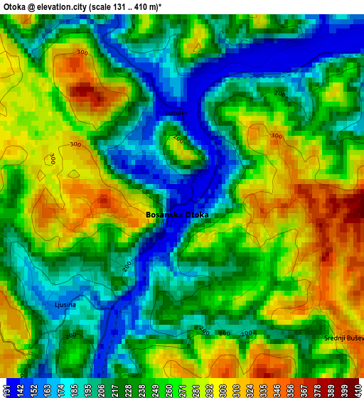
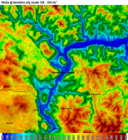
Below is the Elevation map of Otoka, which displays elevation range with different colors. Scale of the first map is from 131 to 410 m (430 to 1345 ft) with average elevation of 243.5 meters (=799 ft) [note 1]
These maps also provides idea of topography and contour of this city, they are displayed at different zoom levels. More info about maps, scale and edge coordinates you can find below images.
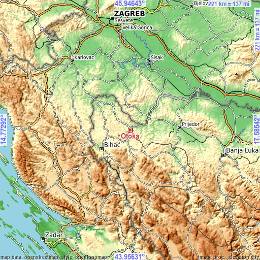
| \ | Map #1 | Map #2 | Topo.Map |
| Scale [m] | 131..410 m | 126..434 m | × |
| Scale [ft] | 430..1345 ft | 413..1424 ft | × |
| Average | 243.5 m = 799 ft | 280.1 m = 919 ft | × |
| Width | 6.91 km = 4.3 mi | 13.83 km = 8.6 mi | 221.3 km = 137.5 mi |
| Height | 6.91 km = 4.3 mi | 13.83 km = 8.6 mi | 221.3 km = 137.5 mi |
| ↑Max Latitude | 44.991087° | 45.022158° | 45.94643° |
| Latitude at center | 44.96° | 44.96° | 44.96° |
| ↓Min Latitude | 44.928896° | 44.897775° | 43.95631° |
| ← Min Longitude | 16.135225° | 16.091279° | 14.77292° |
| Longitude center | 16.17917° | 16.17917° | 16.17917° |
| →Max Longitude | 16.223115° | 16.267061° | 17.58542° |
Nearby cities:
Cities around Otoka sort by population:
• Cazin elevation 325 m
18.6 km,  272°
272°
• Bosanska Krupa 153 m
8.9 km,  194°
194°
• Stijena 354 m
12.6 km,  257°
257°
• Todorovo 331 m
24.2 km,  306°
306°
• Novi Grad 127 m
18.3 km,  58°
58°
• Bužim 218 m
15.5 km, 312°
• Varoška Rijeka 193 m
19.1 km,  318°
318°
• Ostrožac 385 m
19.6 km,  253°
253°
• Gornja Koprivna 408 m
18.5 km,  287°
287°
• Jezerski 282 m
7.1 km, 289°
• Skokovi 462 m
22.3 km, 290°
• Donji Dubovik 324 m
13.9 km,  124°
124°
Multilingual:
 En español:
Otoka elevación 141 m.
 En France:
Otoka élévation 141 m.


Sources and notes:
- [note 1] Map square and city borders are not equal. Map elevation data is calculated only from area inside that square.
- [src 1] Elevation data from geonames database provided with same terms of usage.
- [src 2] The elevation map of Otoka is generated using elevation data from NASA's 3 arcsec (90m) resolution SRTM data.
- [src 3] Base (background) map © OpenStreetMap contributors tiles are generated by Geofabrik and OpenTopoMap.
Copyright & License:
This Otoka Elevation Map is licensed under CC BY-SA. You may reuse any part from this page, if you give a proper credit by linking to this URL:
 More info on terms of use page.