Travnik elevation
Travnik (Federation of B&H), Bosnia and Herzegovina elevation is 507 meters and Travnik elevation in feet is 1663 ft above sea level [src 1]. Travnik is a seat of a second-order administrative division (feature code) with elevation that is 144 meters (472 ft) bigger than average city elevation in Bosnia and Herzegovina.
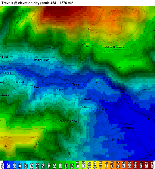
Below is the Elevation map of Travnik, which displays elevation range with different colors. Scale of the first map is from 454 to 1576 m (1490 to 5171 ft) with average elevation of 801.1 meters (=2628 ft) [note 1]
These maps also provides idea of topography and contour of this city, they are displayed at different zoom levels. More info about maps, scale and edge coordinates you can find below images.
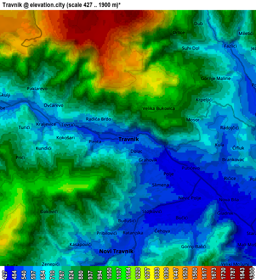
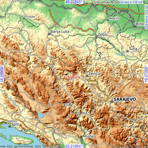
| \ | Map #1 | Map #2 | Topo.Map |
| Scale [m] | 454..1576 m | 427..1900 m | × |
| Scale [ft] | 1490..5171 ft | 1401..6234 ft | × |
| Average | 801.1 m = 2628 ft | 849.1 m = 2786 ft | × |
| Width | 7 km = 4.3 mi | 14.01 km = 8.7 mi | 224.1 km = 139.2 mi |
| Height | 7 km = 4.3 mi | 14.01 km = 8.7 mi | 224.1 km = 139.2 mi |
| ↑Max Latitude | 44.257852° | 44.289318° | 45.22545° |
| Latitude at center | 44.22637° | 44.22637° | 44.22637° |
| ↓Min Latitude | 44.194871° | 44.163355° | 43.21004° |
| ← Min Longitude | 17.621885° | 17.577939° | 16.25958° |
| Longitude center | 17.66583° | 17.66583° | 17.66583° |
| →Max Longitude | 17.709775° | 17.753721° | 19.07208° |
Nearby cities:
Cities around Travnik sort by population:
• Zenica elevation 325 m
19.2 km,  98°
98°
• Bugojno 565 m
25.5 km,  222°
222°
• Novi Travnik 507 m
6.2 km,  185°
185°
• Vitez 410 m
12.7 km,  128°
128°
• Donji Vakuf 515 m
23.1 km,  246°
246°
• Željezno Polje 528 m
29.1 km,  48°
48°
• Kačuni 442 m
28.3 km, 129°
• Busovača 393 m
22.2 km, 130°
• Turbe 597 m
7.5 km,  284°
284°
• Pajić Polje 620 m
30 km,  201°
201°
• Lokvine 399 m
15.4 km, 99°
• Dobratići 1147 m
26.2 km,  310°
310°
Multilingual:
 En español:
Travnik elevación 507 m.
 En France:
Travnik élévation 507 m.


Sources and notes:
- [note 1] Map square and city borders are not equal. Map elevation data is calculated only from area inside that square.
- [src 1] Elevation data from geonames database provided with same terms of usage.
- [src 2] The elevation map of Travnik is generated using elevation data from NASA's 3 arcsec (90m) resolution SRTM data.
- [src 3] Base (background) map © OpenStreetMap contributors tiles are generated by Geofabrik and OpenTopoMap.
Copyright & License:
This Travnik Elevation Map is licensed under CC BY-SA. You may reuse any part from this page, if you give a proper credit by linking to this URL:
 More info on terms of use page.