Vareš elevation
Vareš (Federation of B&H), Bosnia and Herzegovina elevation is 845 meters and Vareš elevation in feet is 2772 ft above sea level [src 1]. Vareš is a seat of a third-order administrative division (feature code) with elevation that is 482 meters (1581 ft) bigger than average city elevation in Bosnia and Herzegovina.
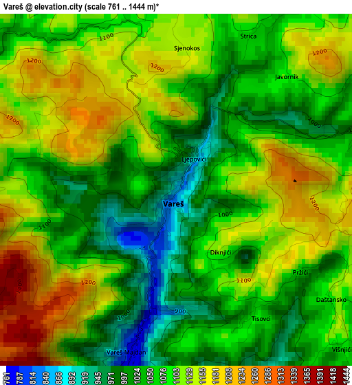
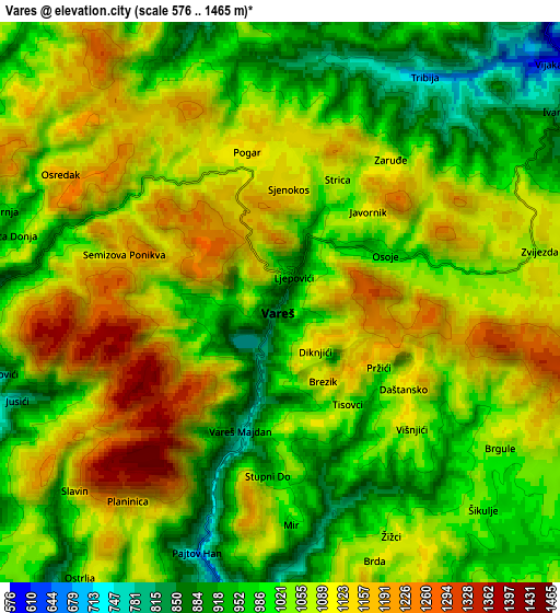
Below is the Elevation map of Vareš, which displays elevation range with different colors. Scale of the first map is from 761 to 1444 m (2497 to 4738 ft) with average elevation of 1089.2 meters (=3573 ft) [note 1]
These maps also provides idea of topography and contour of this city, they are displayed at different zoom levels. More info about maps, scale and edge coordinates you can find below images.
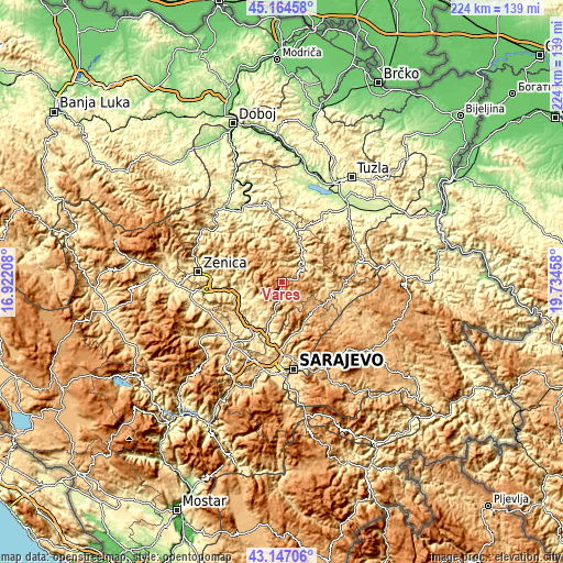
| \ | Map #1 | Map #2 | Topo.Map |
| Scale [m] | 761..1444 m | 576..1465 m | × |
| Scale [ft] | 2497..4738 ft | 1890..4806 ft | × |
| Average | 1089.2 m = 3573 ft | 1052.1 m = 3452 ft | × |
| Width | 7.01 km = 4.4 mi | 14.02 km = 8.7 mi | 224.3 km = 139.4 mi |
| Height | 7.01 km = 4.4 mi | 14.02 km = 8.7 mi | 224.3 km = 139.4 mi |
| ↑Max Latitude | 44.195955° | 44.227454° | 45.16458° |
| Latitude at center | 44.16444° | 44.16444° | 44.16444° |
| ↓Min Latitude | 44.132908° | 44.101359° | 43.14706° |
| ← Min Longitude | 18.284385° | 18.240439° | 16.92208° |
| Longitude center | 18.32833° | 18.32833° | 18.32833° |
| →Max Longitude | 18.372275° | 18.416221° | 19.73458° |
Nearby cities:
Cities around Vareš sort by population:
• Visoko elevation 423 m
22.9 km,  211°
211°
• Kakanj 399 m
16.8 km,  257°
257°
• Vogošća 509 m
29.2 km,  177°
177°
• Ilijaš 463 m
24.1 km,  190°
190°
• Mahala 485 m
17.9 km,  198°
198°
• Gornje Moštre 410 m
21.3 km,  220°
220°
• Dobrinje 425 m
21 km,  232°
232°
• Careva Ćuprija 384 m
13.9 km,  35°
35°
• Gornja Breza 677 m
15.6 km, 205°
• Olovo 538 m
20.5 km,  101°
101°
• Vozuća 326 m
21.7 km,  5°
5°
• Breza 497 m
17.1 km, 198°
Multilingual:
 En español:
Vareš elevación 845 m.
 En France:
Vareš élévation 845 m.


Sources and notes:
- [note 1] Map square and city borders are not equal. Map elevation data is calculated only from area inside that square.
- [src 1] Elevation data from geonames database provided with same terms of usage.
- [src 2] The elevation map of Vareš is generated using elevation data from NASA's 3 arcsec (90m) resolution SRTM data.
- [src 3] Base (background) map © OpenStreetMap contributors tiles are generated by Geofabrik and OpenTopoMap.
Copyright & License:
This Vareš Elevation Map is licensed under CC BY-SA. You may reuse any part from this page, if you give a proper credit by linking to this URL:
 More info on terms of use page.