Zborište elevation
Zborište (Federation of B&H), Bosnia and Herzegovina elevation is 234 meters and Zborište elevation in feet is 768 ft above sea level [src 1]. Zborište is a populated locality (feature code) with elevation that is 129 meters (423 ft) smaller than average city elevation in Bosnia and Herzegovina.
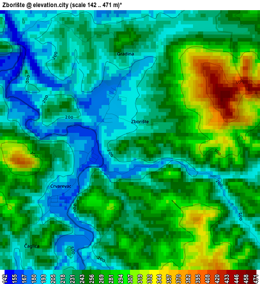
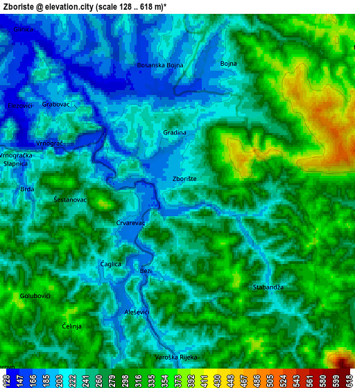
Below is the Elevation map of Zborište, which displays elevation range with different colors. Scale of the first map is from 142 to 471 m (466 to 1545 ft) with average elevation of 243.9 meters (=800 ft) [note 1]
These maps also provides idea of topography and contour of this city, they are displayed at different zoom levels. More info about maps, scale and edge coordinates you can find below images.
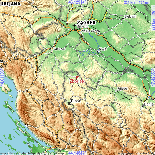
| \ | Map #1 | Map #2 | Topo.Map |
| Scale [m] | 142..471 m | 128..618 m | × |
| Scale [ft] | 466..1545 ft | 420..2028 ft | × |
| Average | 243.9 m = 800 ft | 263.3 m = 864 ft | × |
| Width | 6.89 km = 4.3 mi | 13.79 km = 8.6 mi | 220.6 km = 137.1 mi |
| Height | 6.89 km = 4.3 mi | 13.79 km = 8.6 mi | 220.6 km = 137.1 mi |
| ↑Max Latitude | 45.176916° | 45.207886° | 46.12914° |
| Latitude at center | 45.14593° | 45.14593° | 45.14593° |
| ↓Min Latitude | 45.114927° | 45.083907° | 44.14547° |
| ← Min Longitude | 15.973335° | 15.929389° | 14.61103° |
| Longitude center | 16.01728° | 16.01728° | 16.01728° |
| →Max Longitude | 16.061225° | 16.105171° | 17.42353° |
Nearby cities:
Cities around Zborište sort by population:
• Velika Kladuša elevation 160 m
17.1 km,  284°
284°
• Todorovo 331 m
9.3 km,  226°
226°
• Bužim 218 m
10.3 km,  173°
173°
• Vrnograč 162 m
5.3 km,  291°
291°
• Podzvizd 239 m
11.7 km, 285°
• Varoška Rijeka 193 m
6.3 km,  178°
178°
• Pećigrad 290 m
13.9 km,  222°
222°
• Mala Kladuša 161 m
13 km,  264°
264°
• Šumatac 175 m
13.6 km,  246°
246°
• Gornja Koprivna 408 m
15.8 km,  198°
198°
• Jezerski 282 m
19.2 km,  161°
161°
• Skokovi 462 m
15.1 km,  212°
212°
Multilingual:
 En español:
Zborište elevación 234 m.
 En France:
Zborište élévation 234 m.
 Auf Deutsch:
Zborište höhe über dem Meeresspiegel ist 234 m.

Sources and notes:
- [note 1] Map square and city borders are not equal. Map elevation data is calculated only from area inside that square.
- [src 1] Elevation data from geonames database provided with same terms of usage.
- [src 2] The elevation map of Zborište is generated using elevation data from NASA's 3 arcsec (90m) resolution SRTM data.
- [src 3] Base (background) map © OpenStreetMap contributors tiles are generated by Geofabrik and OpenTopoMap.
Copyright & License:
This Zborište Elevation Map is licensed under CC BY-SA. You may reuse any part from this page, if you give a proper credit by linking to this URL:
 More info on terms of use page.