Aghstafa elevation
Aghstafa (Ağstafa), Azerbaijan elevation is 327 meters and Aghstafa elevation in feet is 1073 ft above sea level [src 1]. Aghstafa is a seat of a first-order administrative division (feature code) with elevation that is 33 meters (108 ft) smaller than average city elevation in Azerbaijan.
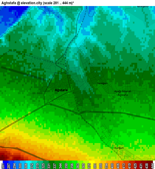
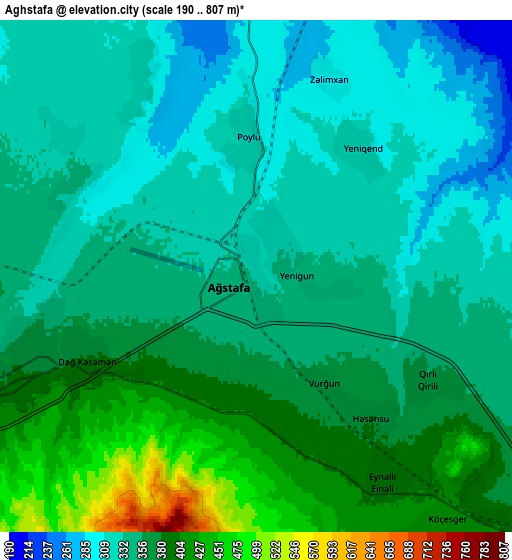
Below is the Elevation map of Aghstafa, which displays elevation range with different colors. Scale of the first map is from 281 to 444 m (922 to 1457 ft) with average elevation of 339.8 meters (=1115 ft) [note 1]
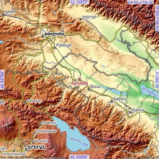
These maps also provides idea of topography and contour of this city, they are displayed at different zoom levels. More info about maps, scale and edge coordinates you can find below images.
| \ | Map #1 | Map #2 | Topo.Map |
| Scale [m] | 281..444 m | 190..807 m | × |
| Scale [ft] | 922..1457 ft | 623..2648 ft | × |
| Average | 339.8 m = 1115 ft | 355.5 m = 1166 ft | × |
| Width | 7.36 km = 4.6 mi | 14.72 km = 9.1 mi | 235.6 km = 146.4 mi |
| Height | 7.36 km = 4.6 mi | 14.72 km = 9.1 mi | 235.6 km = 146.4 mi |
| ↑Max Latitude | 41.151988° | 41.185069° | 42.16972° |
| Latitude at center | 41.11889° | 41.11889° | 41.11889° |
| ↓Min Latitude | 41.085776° | 41.052645° | 40.05096° |
| ← Min Longitude | 45.409945° | 45.365999° | 44.04764° |
| Longitude center | 45.45389° | 45.45389° | 45.45389° |
| →Max Longitude | 45.497835° | 45.541781° | 46.86014° |
Nearby cities:
Cities around Aghstafa sort by population:
• Shamkhor elevation 462 m
57.2 km,  124°
124°
• Qazax 378 m
8 km,  248°
248°
• Tovuz 421 m
20.3 km,  133°
133°
• Dzagam 357 m
43.4 km, 123°
• Dolyar 341 m
56.5 km, 120°
• Dondar Quşçu 483 m
23 km,  142°
142°
• Çatax 1417 m
44.5 km,  168°
168°
• Qaraxanlı 354 m
18.8 km, 116°
• Vurğun 356 m
3 km,  151°
151°
• Yanıqlı 632 m
36.1 km, 148°
• Çobansığnaq 1341 m
45.9 km, 152°
• Saloğlu 249 m
19.3 km,  334°
334°
Multilingual:
 En español:
Aghstafa elevación 327 m.
 En France:
Aghstafa élévation 327 m.
 Auf Deutsch:
Aghstafa höhe über dem Meeresspiegel ist 327 m.

Sources and notes:
- [note 1] Map square and city borders are not equal. Map elevation data is calculated only from area inside that square.
- [src 1] Elevation data from geonames database provided with same terms of usage.
- [src 2] The elevation map of Aghstafa is generated using elevation data from NASA's 3 arcsec (90m) resolution SRTM data.
- [src 3] Base (background) map © OpenStreetMap contributors tiles are generated by Geofabrik and OpenTopoMap.
Copyright & License:
This Aghstafa Elevation Map is licensed under CC BY-SA. You may reuse any part from this page, if you give a proper credit by linking to this URL:
 More info on terms of use page.