Dzagam elevation
Dzagam (Şǝmkir), Azerbaijan elevation is 357 meters and Dzagam elevation in feet is 1171 ft above sea level [src 1]. Dzagam is a populated place (feature code) with elevation that is 3 meters (10 ft) smaller than average city elevation in Azerbaijan.
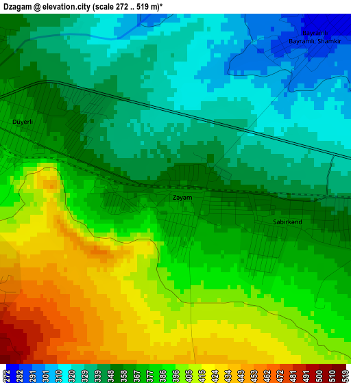
Below is the Elevation map of Dzagam, which displays elevation range with different colors. Scale of the first map is from 272 to 519 m (892 to 1703 ft) with average elevation of 368.3 meters (=1208 ft) [note 1]
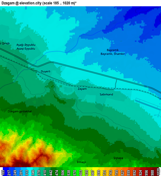
These maps also provides idea of topography and contour of this city, they are displayed at different zoom levels. More info about maps, scale and edge coordinates you can find below images.
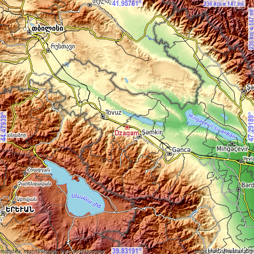
| \ | Map #1 | Map #2 | Topo.Map |
| Scale [m] | 272..519 m | 185..1020 m | × |
| Scale [ft] | 892..1703 ft | 607..3346 ft | × |
| Average | 368.3 m = 1208 ft | 397.1 m = 1303 ft | × |
| Width | 7.39 km = 4.6 mi | 14.77 km = 9.2 mi | 236.4 km = 146.9 mi |
| Height | 7.39 km = 4.6 mi | 14.77 km = 9.2 mi | 236.3 km = 146.8 mi |
| ↑Max Latitude | 40.936506° | 40.969696° | 41.95761° |
| Latitude at center | 40.9033° | 40.9033° | 40.9033° |
| ↓Min Latitude | 40.870077° | 40.836838° | 39.83191° |
| ← Min Longitude | 45.841695° | 45.797749° | 44.47939° |
| Longitude center | 45.88564° | 45.88564° | 45.88564° |
| →Max Longitude | 45.929585° | 45.973531° | 47.29189° |
Nearby cities:
Cities around Dzagam sort by population:
• Shamkhor elevation 462 m
13.8 km,  126°
126°
• Tovuz 421 m
23.8 km,  294°
294°
• Kyadabek 1460 m
37.5 km,  189°
189°
• Qarayeri 255 m
38.3 km,  109°
109°
• Dolyar 341 m
13.3 km, 109°
• Dondar Quşçu 483 m
23.1 km,  284°
284°
• Çatax 1417 m
33.8 km,  234°
234°
• Qaraxanlı 354 m
24.8 km,  308°
308°
• Yanıqlı 632 m
18.5 km,  248°
248°
• Arıqdam 1508 m
35.3 km, 191°
• Qasım İsmayılov 228 m
33 km, 107°
• Çobansığnaq 1341 m
22.6 km,  221°
221°
Multilingual:
 En español:
Dzagam elevación 357 m.
 En France:
Dzagam élévation 357 m.


Sources and notes:
- [note 1] Map square and city borders are not equal. Map elevation data is calculated only from area inside that square.
- [src 1] Elevation data from geonames database provided with same terms of usage.
- [src 2] The elevation map of Dzagam is generated using elevation data from NASA's 3 arcsec (90m) resolution SRTM data.
- [src 3] Base (background) map © OpenStreetMap contributors tiles are generated by Geofabrik and OpenTopoMap.
Copyright & License:
This Dzagam Elevation Map is licensed under CC BY-SA. You may reuse any part from this page, if you give a proper credit by linking to this URL:
 More info on terms of use page.