Bendigo city centre elevation
Bendigo city centre (Victoria, Greater Bendigo), Australia elevation is 231 meters and Bendigo city centre elevation in feet is 758 ft above sea level [src 1]. Bendigo city centre is a section of populated place (feature code) with elevation that is 118 meters (387 ft) bigger than average city elevation in Australia.
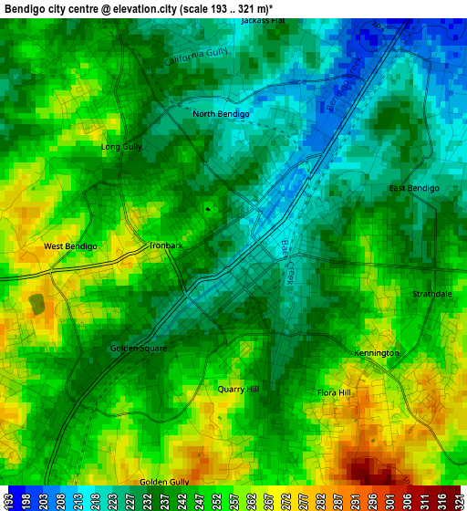
Below is the Elevation map of Bendigo city centre, which displays elevation range with different colors. Scale of the first map is from 193 to 321 m (633 to 1053 ft) with average elevation of 242.7 meters (=796 ft) [note 1]
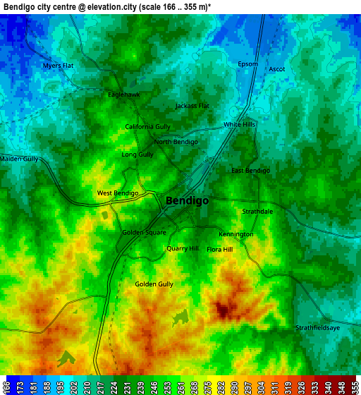
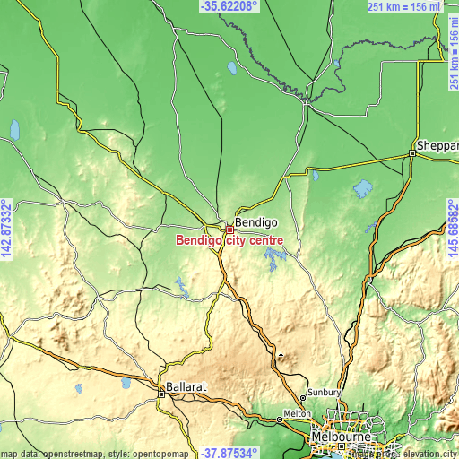
These maps also provides idea of topography and contour of this city, they are displayed at different zoom levels. More info about maps, scale and edge coordinates you can find below images.
| \ | Map #1 | Map #2 | Topo.Map |
| Scale [m] | 193..321 m | 166..355 m | × |
| Scale [ft] | 633..1053 ft | 545..1165 ft | × |
| Average | 242.7 m = 796 ft | 236.8 m = 777 ft | × |
| Width | 7.83 km = 4.9 mi | 15.66 km = 9.7 mi | 250.5 km = 155.7 mi |
| Height | 7.83 km = 4.9 mi | 15.66 km = 9.7 mi | 250.5 km = 155.7 mi |
| ↑Max Latitude | -36.721764° | -36.686531° | -35.62208° |
| Latitude at center | -36.75698° | -36.75698° | -36.75698° |
| ↓Min Latitude | -36.79218° | -36.827364° | -37.87534° |
| ← Min Longitude | 144.235625° | 144.191679° | 142.87332° |
| Longitude center | 144.27957° | 144.27957° | 144.27957° |
| →Max Longitude | 144.323515° | 144.367461° | 145.68582° |
Nearby cities:
Cities around Bendigo city centre sort by population:
• Bendigo elevation 221 m
0.1 km,  155°
155°
• Golden Square 235 m
3 km,  233°
233°
• Strathdale 241 m
3.3 km,  106°
106°
• Kennington 270 m
2.6 km,  127°
127°
• California Gully 241 m
3.5 km,  331°
331°
• Flora Hill 272 m
3.1 km,  152°
152°
• North Bendigo 218 m
1.7 km,  26°
26°
• Long Gully 240 m
2.5 km,  308°
308°
• White Hills 204 m
3.9 km,  36°
36°
• Quarry Hill 262 m
2.2 km,  178°
178°
• East Bendigo 219 m
3.9 km,  63°
63°
• Ironbark 253 m
1.4 km,  279°
279°
Multilingual:
 En español:
Bendigo city centre elevación 231 m.
 En France:
Bendigo city centre élévation 231 m.
 Auf Deutsch:
Bendigo city centre höhe über dem Meeresspiegel ist 231 m.
 На русском:
Bendigo city centre высота над уровнем моря 231 м
Sources and notes:
- [note 1] Map square and city borders are not equal. Map elevation data is calculated only from area inside that square.
- [src 1] Elevation data from geonames database provided with same terms of usage.
- [src 2] The elevation map of Bendigo city centre is generated using elevation data from NASA's 3 arcsec (90m) resolution SRTM data.
- [src 3] Base (background) map © OpenStreetMap contributors tiles are generated by Geofabrik and OpenTopoMap.
Copyright & License:
This Bendigo city centre Elevation Map is licensed under CC BY-SA. You may reuse any part from this page, if you give a proper credit by linking to this URL:
 More info on terms of use page.