Bathurst city centre elevation
Bathurst city centre (New South Wales, Bathurst Regional), Australia elevation is 672 meters and Bathurst city centre elevation in feet is 2205 ft above sea level [src 1]. Bathurst city centre is a section of populated place (feature code) with elevation that is 559 meters (1834 ft) bigger than average city elevation in Australia.
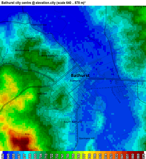
Below is the Elevation map of Bathurst city centre, which displays elevation range with different colors. Scale of the first map is from 640 to 878 m (2100 to 2881 ft) with average elevation of 689.1 meters (=2261 ft) [note 1]
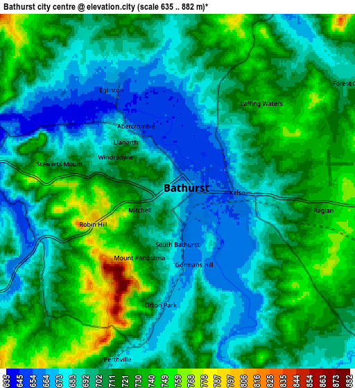
These maps also provides idea of topography and contour of this city, they are displayed at different zoom levels. More info about maps, scale and edge coordinates you can find below images.
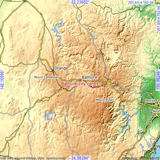
| \ | Map #1 | Map #2 | Topo.Map |
| Scale [m] | 640..878 m | 635..882 m | × |
| Scale [ft] | 2100..2881 ft | 2083..2894 ft | × |
| Average | 689.1 m = 2261 ft | 705.9 m = 2316 ft | × |
| Width | 8.16 km = 5.1 mi | 16.31 km = 10.1 mi | 261 km = 162.2 mi |
| Height | 8.16 km = 5.1 mi | 16.31 km = 10.1 mi | 261 km = 162.2 mi |
| ↑Max Latitude | -33.381472° | -33.344769° | -32.23652° |
| Latitude at center | -33.41816° | -33.41816° | -33.41816° |
| ↓Min Latitude | -33.454832° | -33.491489° | -34.58394° |
| ← Min Longitude | 149.532265° | 149.488319° | 148.16996° |
| Longitude center | 149.57621° | 149.57621° | 149.57621° |
| →Max Longitude | 149.620155° | 149.664101° | 150.98246° |
Nearby cities:
Cities around Bathurst city centre sort by population:
• Bathurst elevation 819 m
0.4 km,  67°
67°
• Kelso 649 m
2.2 km,  85°
85°
• West Bathurst 714 m
1.6 km,  309°
309°
• Blayney 870 m
32.5 km,  247°
247°
• Windradyne 708 m
3.2 km,  296°
296°
• Eglinton 657 m
5.3 km,  328°
328°
• Llanarth 681 m
3.3 km,  315°
315°
• Mitchell 712 m
2.1 km,  240°
240°
• South Bathurst 680 m
2.3 km,  189°
189°
• Millthorpe 969 m
36.4 km,  265°
265°
• Raglan 764 m
8.4 km, 88°
• Abercrombie 669 m
4.3 km, 319°
Multilingual:
 En español:
Bathurst city centre elevación 672 m.
 En France:
Bathurst city centre élévation 672 m.
 Auf Deutsch:
Bathurst city centre höhe über dem Meeresspiegel ist 672 m.
 На русском:
Bathurst city centre высота над уровнем моря 672 м
Sources and notes:
- [note 1] Map square and city borders are not equal. Map elevation data is calculated only from area inside that square.
- [src 1] Elevation data from geonames database provided with same terms of usage.
- [src 2] The elevation map of Bathurst city centre is generated using elevation data from NASA's 3 arcsec (90m) resolution SRTM data.
- [src 3] Base (background) map © OpenStreetMap contributors tiles are generated by Geofabrik and OpenTopoMap.
Copyright & License:
This Bathurst city centre Elevation Map is licensed under CC BY-SA. You may reuse any part from this page, if you give a proper credit by linking to this URL:
 More info on terms of use page.