Rangeville elevation
Rangeville (Queensland, Toowoomba), Australia elevation is 657 meters and Rangeville elevation in feet is 2156 ft above sea level [src 1]. Rangeville is a section of populated place (feature code) with elevation that is 544 meters (1785 ft) bigger than average city elevation in Australia.
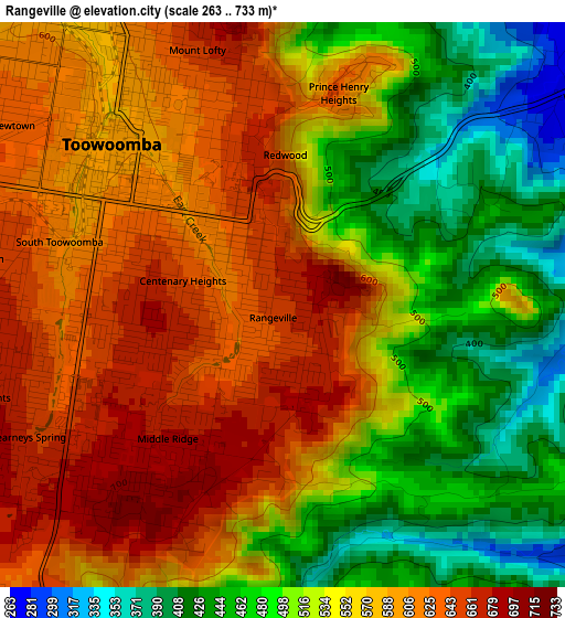
Below is the Elevation map of Rangeville, which displays elevation range with different colors. Scale of the first map is from 263 to 733 m (863 to 2405 ft) with average elevation of 548.9 meters (=1801 ft) [note 1]
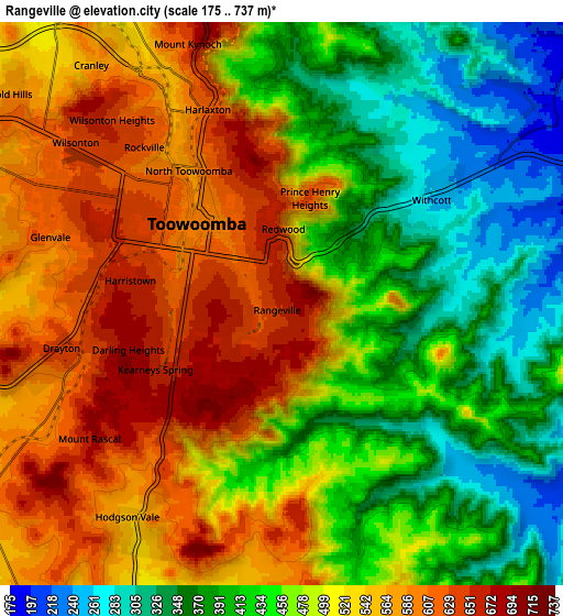
These maps also provides idea of topography and contour of this city, they are displayed at different zoom levels. More info about maps, scale and edge coordinates you can find below images.
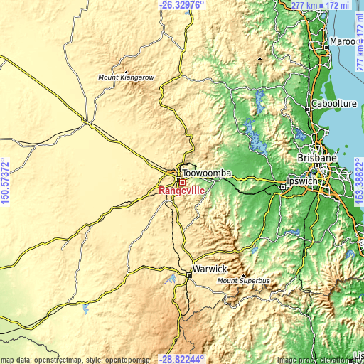
| \ | Map #1 | Map #2 | Topo.Map |
| Scale [m] | 263..733 m | 175..737 m | × |
| Scale [ft] | 863..2405 ft | 574..2418 ft | × |
| Average | 548.9 m = 1801 ft | 485.4 m = 1593 ft | × |
| Width | 8.66 km = 5.4 mi | 17.32 km = 10.8 mi | 277.2 km = 172.2 mi |
| Height | 8.66 km = 5.4 mi | 17.32 km = 10.8 mi | 277.2 km = 172.2 mi |
| ↑Max Latitude | -27.544223° | -27.505251° | -26.32976° |
| Latitude at center | -27.58318° | -27.58318° | -27.58318° |
| ↓Min Latitude | -27.622124° | -27.661053° | -28.82244° |
| ← Min Longitude | 151.936025° | 151.892079° | 150.57372° |
| Longitude center | 151.97997° | 151.97997° | 151.97997° |
| →Max Longitude | 152.023915° | 152.067861° | 153.38622° |
Nearby cities:
Cities around Rangeville sort by population:
• Toowoomba elevation 599 m
3.6 km,  314°
314°
• Newtown 636 m
5.6 km,  302°
302°
• Kearneys Spring 672 m
4.5 km,  237°
237°
• Harristown 669 m
4.6 km,  269°
269°
• Middle Ridge 698 m
3 km,  205°
205°
• Centenary Heights 673 m
1.8 km,  256°
256°
• East Toowoomba 648 m
1.5 km,  337°
337°
• South Toowoomba 606 m
3.6 km,  292°
292°
• Darling Heights 691 m
5.1 km,  253°
253°
• Mount Lofty 681 m
4.2 km,  349°
349°
• North Toowoomba 641 m
4.7 km, 336°
• Withcott 262 m
5.4 km,  53°
53°
Multilingual:
 En español:
Rangeville elevación 657 m.
 En France:
Rangeville élévation 657 m.
 Auf Deutsch:
Rangeville höhe über dem Meeresspiegel ist 657 m.

Sources and notes:
- [note 1] Map square and city borders are not equal. Map elevation data is calculated only from area inside that square.
- [src 1] Elevation data from geonames database provided with same terms of usage.
- [src 2] The elevation map of Rangeville is generated using elevation data from NASA's 3 arcsec (90m) resolution SRTM data.
- [src 3] Base (background) map © OpenStreetMap contributors tiles are generated by Geofabrik and OpenTopoMap.
Copyright & License:
This Rangeville Elevation Map is licensed under CC BY-SA. You may reuse any part from this page, if you give a proper credit by linking to this URL:
 More info on terms of use page.