Avondale elevation
Avondale (New South Wales, Wollongong), Australia elevation is 45 meters and Avondale elevation in feet is 148 ft above sea level [src 1]. Avondale is a section of populated place (feature code) with elevation that is 68 meters (223 ft) smaller than average city elevation in Australia.
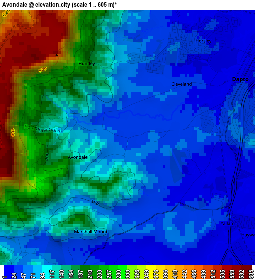
Below is the Elevation map of Avondale, which displays elevation range with different colors. Scale of the first map is from 1 to 605 m (3 to 1985 ft) with average elevation of 119.5 meters (=392 ft) [note 1]
These maps also provides idea of topography and contour of this city, they are displayed at different zoom levels. More info about maps, scale and edge coordinates you can find below images.
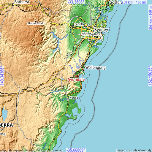
| \ | Map #1 | Topo.Map |
| Scale [m] | 1..605 m | × |
| Scale [ft] | 3..1985 ft | × |
| Average | 119.5 m = 392 ft | × |
| Width | 8.05 km = 5 mi | 257.7 km = 160.1 mi |
| Height | 8.05 km = 5 mi | 257.7 km = 160.1 mi |
| ↑Max Latitude | -34.481283° | -33.3508° |
| Latitude at center | -34.5175° | -34.5175° |
| ↓Min Latitude | -34.553701° | -35.66809° |
| ← Min Longitude | 150.706155° | 149.34385° |
| Longitude center | 150.7501° | 150.7501° |
| →Max Longitude | 150.794045° | 152.15635° |
Nearby cities:
Cities around Avondale sort by population:
• Albion Park elevation 13 m
6.4 km,  158°
158°
• Dapto 13 m
4.3 km,  69°
69°
• Horsley 26 m
4.2 km,  37°
37°
• Berkeley 4 m
9.9 km, 67°
• Albion Park Rail 14 m
6.6 km,  144°
144°
• Oak Flats 18 m
8.3 km,  127°
127°
• Kanahooka 31 m
6.1 km,  61°
61°
• Mount Warrigal 12 m
8.7 km,  112°
112°
• Farmborough Heights 135 m
9 km, 39°
• Koonawarra 20 m
5.6 km, 72°
• Blackbutt 73 m
10.1 km, 126°
• Lake Illawarra 13 m
10.3 km, 108°
Multilingual:
 En español:
Avondale elevación 45 m.
 En France:
Avondale élévation 45 m.


Sources and notes:
- [note 1] Map square and city borders are not equal. Map elevation data is calculated only from area inside that square.
- [src 1] Elevation data from geonames database provided with same terms of usage.
- [src 2] The elevation map of Avondale is generated using elevation data from NASA's 3 arcsec (90m) resolution SRTM data.
- [src 3] Base (background) map © OpenStreetMap contributors tiles are generated by Geofabrik and OpenTopoMap.
Copyright & License:
This Avondale Elevation Map is licensed under CC BY-SA. You may reuse any part from this page, if you give a proper credit by linking to this URL:
 More info on terms of use page.