Jindalee elevation
Jindalee (Western Australia, Wanneroo), Australia elevation is 42 meters and Jindalee elevation in feet is 138 ft above sea level [src 1]. Jindalee is a section of populated place (feature code) with elevation that is 71 meters (233 ft) smaller than average city elevation in Australia.
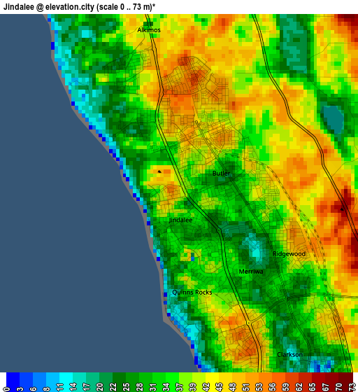
Below is the Elevation map of Jindalee, which displays elevation range with different colors. Scale of the first map is from 0 to 73 m (0 to 240 ft) with average elevation of 37.1 meters (=122 ft) [note 1]
These maps also provides idea of topography and contour of this city, they are displayed at different zoom levels. More info about maps, scale and edge coordinates you can find below images.
| \ | Map #1 | Topo.Map |
| Scale [m] | 0..73 m | × |
| Scale [ft] | 0..240 ft | × |
| Average | 37.1 m = 122 ft | × |
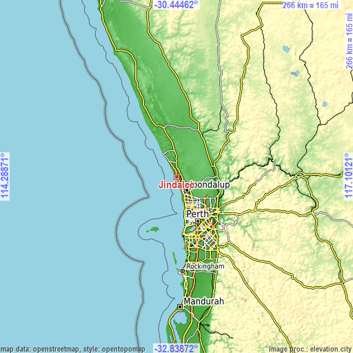
| Width | 8.32 km = 5.2 mi | 266.2 km = 165.4 mi |
| Height | 8.32 km = 5.2 mi | 266.2 km = 165.4 mi |
| ↑Max Latitude | -31.611963° | -30.44462° |
| Latitude at center | -31.64938° | -31.64938° |
| ↓Min Latitude | -31.686782° | -32.83872° |
| ← Min Longitude | 115.651015° | 114.28871° |
| Longitude center | 115.69496° | 115.69496° |
| →Max Longitude | 115.738905° | 117.10121° |
Nearby cities:
Cities around Jindalee sort by population:
• Butler elevation 33 m
1.1 km,  51°
51°
• Clarkson 28 m
4.7 km,  142°
142°
• Quinns Rocks 45 m
2.8 km,  163°
163°
• Mindarie 27 m
4.6 km,  165°
165°
• Carramar 56 m
8.6 km,  122°
122°
• Kinross 43 m
8.7 km,  151°
151°
• Alkimos 46 m
2.3 km,  338°
338°
• Merriwa 20 m
2.4 km, 135°
• Iluka 20 m
10.2 km, 160°
• Ridgewood 48 m
2.9 km, 117°
• Burns Beach 28 m
8.3 km, 163°
• Eglinton 10 m
7 km,  355°
355°
Multilingual:
 En español:
Jindalee elevación 42 m.
 En France:
Jindalee élévation 42 m.


Sources and notes:
- [note 1] Map square and city borders are not equal. Map elevation data is calculated only from area inside that square.
- [src 1] Elevation data from geonames database provided with same terms of usage.
- [src 2] The elevation map of Jindalee is generated using elevation data from NASA's 3 arcsec (90m) resolution SRTM data.
- [src 3] Base (background) map © OpenStreetMap contributors tiles are generated by Geofabrik and OpenTopoMap.
Copyright & License:
This Jindalee Elevation Map is licensed under CC BY-SA. You may reuse any part from this page, if you give a proper credit by linking to this URL:
 More info on terms of use page.