Windsor Gardens elevation
Windsor Gardens (South Australia, Port Adelaide Enfield), Australia elevation is 81 meters and Windsor Gardens elevation in feet is 266 ft above sea level [src 1]. Windsor Gardens is a section of populated place (feature code) with elevation that is 32 meters (105 ft) smaller than average city elevation in Australia.
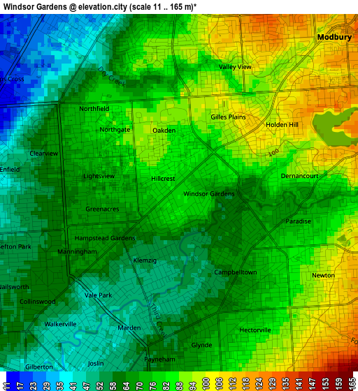
Below is the Elevation map of Windsor Gardens, which displays elevation range with different colors. Scale of the first map is from 11 to 165 m (36 to 541 ft) with average elevation of 74.2 meters (=243 ft) [note 1]
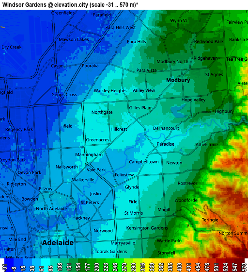
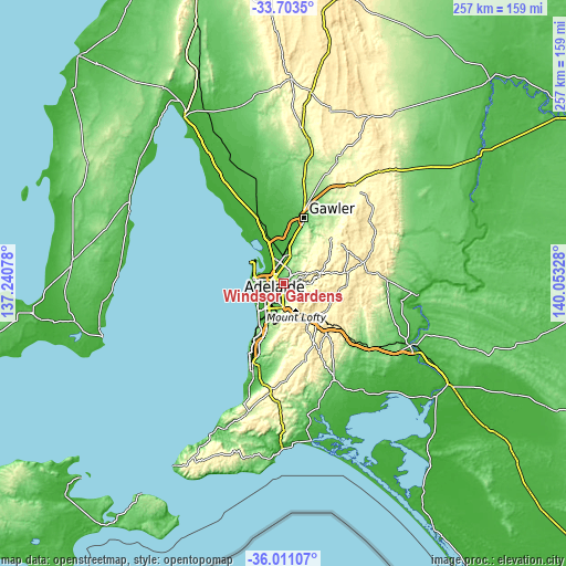
These maps also provides idea of topography and contour of this city, they are displayed at different zoom levels. More info about maps, scale and edge coordinates you can find below images.
| \ | Map #1 | Map #2 | Topo.Map |
| Scale [m] | 11..165 m | -31..570 m | × |
| Scale [ft] | 36..541 ft | -102..1870 ft | × |
| Average | 74.2 m = 243 ft | 106.9 m = 351 ft | × |
| Width | 8.02 km = 5 mi | 16.04 km = 10 mi | 256.6 km = 159.4 mi |
| Height | 8.02 km = 5 mi | 16.04 km = 10 mi | 256.6 km = 159.4 mi |
| ↑Max Latitude | -34.829315° | -34.793234° | -33.7035° |
| Latitude at center | -34.86538° | -34.86538° | -34.86538° |
| ↓Min Latitude | -34.901429° | -34.937462° | -36.01107° |
| ← Min Longitude | 138.603085° | 138.559139° | 137.24078° |
| Longitude center | 138.64703° | 138.64703° | 138.64703° |
| →Max Longitude | 138.690975° | 138.734921° | 140.05328° |
Nearby cities:
Cities around Windsor Gardens sort by population:
• Campbelltown elevation 75 m
2.7 km,  138°
138°
• Paradise 72 m
2.2 km,  114°
114°
• Northgate 73 m
1.8 km,  297°
297°
• Klemzig 52 m
1.9 km,  213°
213°
• Northfield 85 m
2.6 km,  311°
311°
• Dernancourt 94 m
2.7 km,  82°
82°
• Oakden 90 m
1.4 km,  346°
346°
• Gilles Plains 95 m
1.7 km,  9°
9°
• Hillcrest 83 m
0.5 km, 311°
• Greenacres 71 m
1.8 km,  258°
258°
• Felixstow 52 m
2.6 km,  180°
180°
• Hampstead Gardens 66 m
1.9 km,  238°
238°
Multilingual:
 En español:
Windsor Gardens elevación 81 m.
 En France:
Windsor Gardens élévation 81 m.
 Auf Deutsch:
Windsor Gardens höhe über dem Meeresspiegel ist 81 m.

Sources and notes:
- [note 1] Map square and city borders are not equal. Map elevation data is calculated only from area inside that square.
- [src 1] Elevation data from geonames database provided with same terms of usage.
- [src 2] The elevation map of Windsor Gardens is generated using elevation data from NASA's 3 arcsec (90m) resolution SRTM data.
- [src 3] Base (background) map © OpenStreetMap contributors tiles are generated by Geofabrik and OpenTopoMap.
Copyright & License:
This Windsor Gardens Elevation Map is licensed under CC BY-SA. You may reuse any part from this page, if you give a proper credit by linking to this URL:
 More info on terms of use page.