Hawthorn elevation
Hawthorn (South Australia, Mitcham), Australia elevation is 73 meters and Hawthorn elevation in feet is 240 ft above sea level [src 1]. Hawthorn is a section of populated place (feature code) with elevation that is 40 meters (131 ft) smaller than average city elevation in Australia.
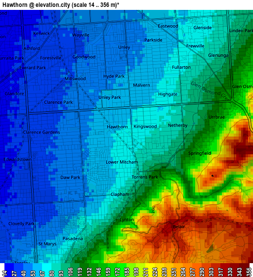
Below is the Elevation map of Hawthorn, which displays elevation range with different colors. Scale of the first map is from 14 to 356 m (46 to 1168 ft) with average elevation of 104.5 meters (=343 ft) [note 1]
These maps also provides idea of topography and contour of this city, they are displayed at different zoom levels. More info about maps, scale and edge coordinates you can find below images.
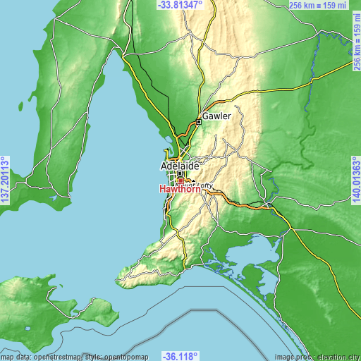
| \ | Map #1 | Topo.Map |
| Scale [m] | 14..356 m | × |
| Scale [ft] | 46..1168 ft | × |
| Average | 104.5 m = 343 ft | × |
| Width | 8.01 km = 5 mi | 256.2 km = 159.2 mi |
| Height | 8.01 km = 5 mi | 256.2 km = 159.2 mi |
| ↑Max Latitude | -34.937823° | -33.81347° |
| Latitude at center | -34.97384° | -34.97384° |
| ↓Min Latitude | -35.009841° | -36.118° |
| ← Min Longitude | 138.563435° | 137.20113° |
| Longitude center | 138.60738° | 138.60738° |
| →Max Longitude | 138.651325° | 140.01363° |
Nearby cities:
Cities around Hawthorn sort by population:
• Colonel Light Gardens elevation 61 m
1.7 km,  213°
213°
• Torrens Park 77 m
0.4 km,  132°
132°
• Malvern 62 m
1.7 km,  16°
16°
• Westbourne Park 55 m
1.1 km,  282°
282°
• Cumberland Park 44 m
1.9 km, 276°
• Panorama 66 m
2 km,  200°
200°
• Lower Mitcham 72 m
0.4 km, 210°
• Mitcham 98 m
1.4 km,  113°
113°
• Highgate 74 m
1.9 km,  44°
44°
• Clapham 71 m
1.9 km, 196°
• Unley Park 63 m
1.1 km,  1°
1°
• Netherby 90 m
1.7 km,  76°
76°
Multilingual:
 En español:
Hawthorn elevación 73 m.
 En France:
Hawthorn élévation 73 m.


Sources and notes:
- [note 1] Map square and city borders are not equal. Map elevation data is calculated only from area inside that square.
- [src 1] Elevation data from geonames database provided with same terms of usage.
- [src 2] The elevation map of Hawthorn is generated using elevation data from NASA's 3 arcsec (90m) resolution SRTM data.
- [src 3] Base (background) map © OpenStreetMap contributors tiles are generated by Geofabrik and OpenTopoMap.
Copyright & License:
This Hawthorn Elevation Map is licensed under CC BY-SA. You may reuse any part from this page, if you give a proper credit by linking to this URL:
 More info on terms of use page.