Tusmore elevation
Tusmore (South Australia, Burnside), Australia elevation is 106 meters and Tusmore elevation in feet is 348 ft above sea level [src 1]. Tusmore is a section of populated place (feature code) with elevation that is 7 meters (23 ft) smaller than average city elevation in Australia.
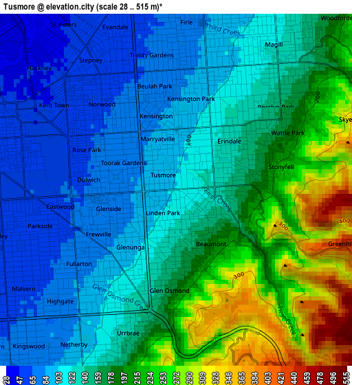
Below is the Elevation map of Tusmore, which displays elevation range with different colors. Scale of the first map is from 28 to 515 m (92 to 1690 ft) with average elevation of 155.2 meters (=509 ft) [note 1]
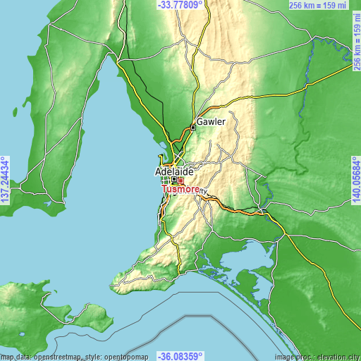
These maps also provides idea of topography and contour of this city, they are displayed at different zoom levels. More info about maps, scale and edge coordinates you can find below images.
| \ | Map #1 | Topo.Map |
| Scale [m] | 28..515 m | × |
| Scale [ft] | 92..1690 ft | × |
| Average | 155.2 m = 509 ft | × |
| Width | 8.01 km = 5 mi | 256.3 km = 159.3 mi |
| Height | 8.01 km = 5 mi | 256.3 km = 159.3 mi |
| ↑Max Latitude | -34.902907° | -33.77809° |
| Latitude at center | -34.93894° | -34.93894° |
| ↓Min Latitude | -34.974957° | -36.08359° |
| ← Min Longitude | 138.606645° | 137.24434° |
| Longitude center | 138.65059° | 138.65059° |
| →Max Longitude | 138.694535° | 140.05684° |
Nearby cities:
Cities around Tusmore sort by population:
• Toorak Gardens elevation 81 m
1.4 km,  289°
289°
• Kensington Park 92 m
2.1 km,  9°
9°
• Beaumont 202 m
1.5 km,  137°
137°
• Glenside 78 m
1.6 km,  254°
254°
• Kensington Gardens 123 m
1.8 km,  34°
34°
• Glenunga 92 m
1.7 km,  221°
221°
• Linden Park 139 m
0.6 km,  210°
210°
• Hazelwood Park 126 m
0.7 km,  94°
94°
• Dulwich 66 m
2.1 km,  277°
277°
• St Georges 134 m
1.5 km,  189°
189°
• Leabrook 118 m
1.3 km,  35°
35°
• Erindale 133 m
1.7 km, 42°
Multilingual:
 En español:
Tusmore elevación 106 m.
 En France:
Tusmore élévation 106 m.


Sources and notes:
- [note 1] Map square and city borders are not equal. Map elevation data is calculated only from area inside that square.
- [src 1] Elevation data from geonames database provided with same terms of usage.
- [src 2] The elevation map of Tusmore is generated using elevation data from NASA's 3 arcsec (90m) resolution SRTM data.
- [src 3] Base (background) map © OpenStreetMap contributors tiles are generated by Geofabrik and OpenTopoMap.
Copyright & License:
This Tusmore Elevation Map is licensed under CC BY-SA. You may reuse any part from this page, if you give a proper credit by linking to this URL:
 More info on terms of use page.