Sadliers Crossing elevation
Sadliers Crossing (Queensland, Ipswich), Australia elevation is 47 meters and Sadliers Crossing elevation in feet is 154 ft above sea level [src 1]. Sadliers Crossing is a section of populated place (feature code) with elevation that is 66 meters (217 ft) smaller than average city elevation in Australia.
Below is the Elevation map of Sadliers Crossing, which displays elevation range with different colors. Scale of the first map is from 0 to 90 m (0 to 295 ft) with average elevation of 36.6 meters (=120 ft) [note 1]
These maps also provides idea of topography and contour of this city, they are displayed at different zoom levels. More info about maps, scale and edge coordinates you can find below images.
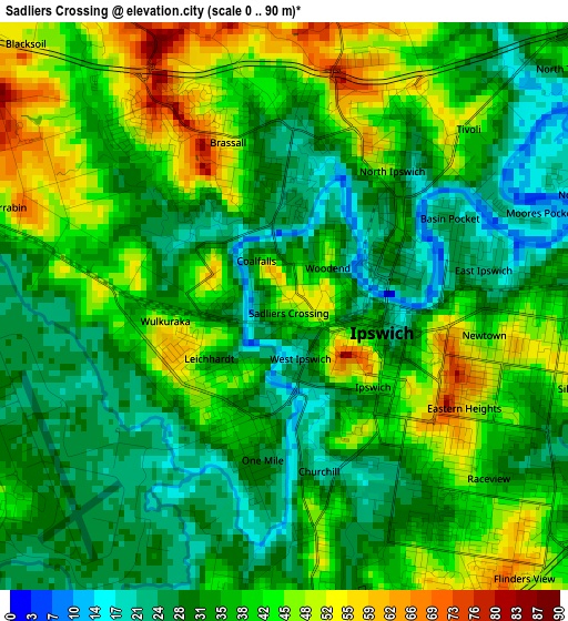
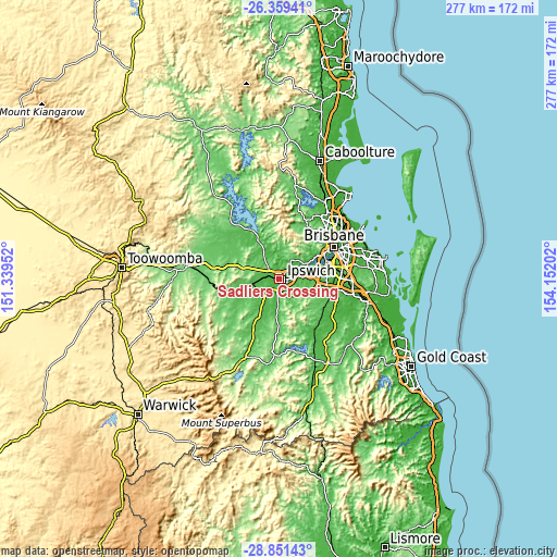
| \ | Map #1 | Topo.Map |
| Scale [m] | 0..90 m | × |
| Scale [ft] | 0..295 ft | × |
| Average | 36.6 m = 120 ft | × |
| Width | 8.66 km = 5.4 mi | 277.1 km = 172.2 mi |
| Height | 8.66 km = 5.4 mi | 277.1 km = 172.2 mi |
| ↑Max Latitude | -27.573563° | -26.35941° |
| Latitude at center | -27.61251° | -27.61251° |
| ↓Min Latitude | -27.651443° | -28.85143° |
| ← Min Longitude | 152.701825° | 151.33952° |
| Longitude center | 152.74577° | 152.74577° |
| →Max Longitude | 152.789715° | 154.15202° |
Nearby cities:
Cities around Sadliers Crossing sort by population:
• Brassall elevation 25 m
1.7 km,  6°
6°
• North Ipswich 30 m
1.9 km,  55°
55°
• Leichhardt 44 m
1.6 km,  226°
226°
• Eastern Heights 43 m
3.7 km,  119°
119°
• Ipswich 14 m
1.9 km,  129°
129°
• East Ipswich 25 m
2.7 km,  75°
75°
• One Mile 39 m
2 km,  203°
203°
• Churchill 46 m
3.3 km,  172°
172°
• Newtown 41 m
3.1 km,  97°
97°
• Tivoli 36 m
3.1 km,  44°
44°
• Woodend 36 m
1.1 km, 42°
• Wulkuraka 24 m
2.4 km,  265°
265°
Multilingual:
 En español:
Sadliers Crossing elevación 47 m.
 En France:
Sadliers Crossing élévation 47 m.
 Auf Deutsch:
Sadliers Crossing höhe über dem Meeresspiegel ist 47 m.

Sources and notes:
- [note 1] Map square and city borders are not equal. Map elevation data is calculated only from area inside that square.
- [src 1] Elevation data from geonames database provided with same terms of usage.
- [src 2] The elevation map of Sadliers Crossing is generated using elevation data from NASA's 3 arcsec (90m) resolution SRTM data.
- [src 3] Base (background) map © OpenStreetMap contributors tiles are generated by Geofabrik and OpenTopoMap.
Copyright & License:
This Sadliers Crossing Elevation Map is licensed under CC BY-SA. You may reuse any part from this page, if you give a proper credit by linking to this URL:
 More info on terms of use page.