Rosebery elevation
Rosebery (Northern Territory, Palmerston), Australia elevation is 13 meters and Rosebery elevation in feet is 43 ft above sea level [src 1]. Rosebery is a section of populated place (feature code) with elevation that is 100 meters (328 ft) smaller than average city elevation in Australia.
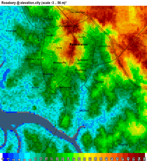
Below is the Elevation map of Rosebery, which displays elevation range with different colors. Scale of the first map is from -3 to 56 m (-10 to 184 ft) with average elevation of 20.8 meters (=68 ft) [note 1]
These maps also provides idea of topography and contour of this city, they are displayed at different zoom levels. More info about maps, scale and edge coordinates you can find below images.
| \ | Map #1 | Map #2 | Topo.Map |
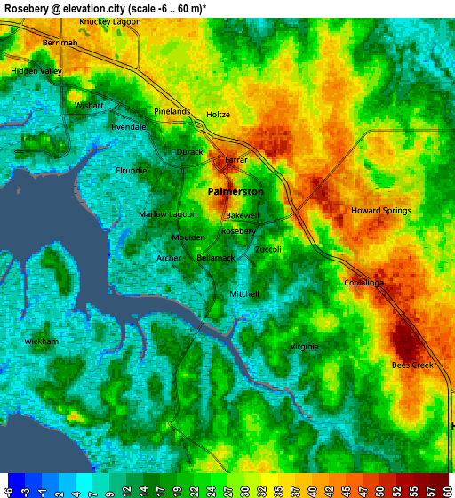
| Scale [m] | -3..56 m | -6..60 m | × |
| Scale [ft] | -10..184 ft | -20..197 ft | × |
| Average | 20.8 m = 68 ft | 22.4 m = 73 ft | × |
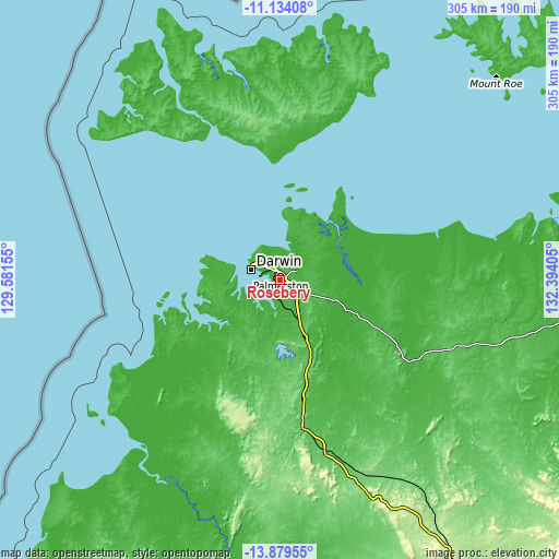
| Width | 9.54 km = 5.9 mi | 19.08 km = 11.9 mi | 305.3 km = 189.7 mi |
| Height | 9.54 km = 5.9 mi | 19.08 km = 11.9 mi | 305.3 km = 189.7 mi |
| ↑Max Latitude | -12.467555° | -12.424642° | -11.13408° |
| Latitude at center | -12.51046° | -12.51046° | -12.51046° |
| ↓Min Latitude | -12.553358° | -12.59625° | -13.87955° |
| ← Min Longitude | 130.943855° | 130.899909° | 129.58155° |
| Longitude center | 130.9878° | 130.9878° | 130.9878° |
| →Max Longitude | 131.031745° | 131.075691° | 132.39405° |
Nearby cities:
Cities around Rosebery sort by population:
• Palmerston elevation 36 m
2.8 km,  349°
349°
• Gray 38 m
2.3 km,  344°
344°
• Woodroffe 26 m
1.3 km,  319°
319°
• Bakewell 29 m
1.6 km,  22°
22°
• Moulden 20 m
1.7 km,  288°
288°
• Driver 24 m
3 km,  333°
333°
• Gunn 25 m
2.6 km,  13°
13°
• Bellamack 17 m
0.9 km,  212°
212°
• Virginia 27 m
4.5 km,  102°
102°
• Johnston 42 m
3.6 km,  45°
45°
• Farrar 30 m
3.5 km, 18°
• Zuccoli 21 m
2.1 km,  80°
80°
Multilingual:
 En español:
Rosebery elevación 13 m.
 En France:
Rosebery élévation 13 m.


Sources and notes:
- [note 1] Map square and city borders are not equal. Map elevation data is calculated only from area inside that square.
- [src 1] Elevation data from geonames database provided with same terms of usage.
- [src 2] The elevation map of Rosebery is generated using elevation data from NASA's 3 arcsec (90m) resolution SRTM data.
- [src 3] Base (background) map © OpenStreetMap contributors tiles are generated by Geofabrik and OpenTopoMap.
Copyright & License:
This Rosebery Elevation Map is licensed under CC BY-SA. You may reuse any part from this page, if you give a proper credit by linking to this URL:
 More info on terms of use page.