Ravenswood elevation
Ravenswood (Tasmania, Launceston), Australia elevation is 90 meters and Ravenswood elevation in feet is 295 ft above sea level [src 1]. Ravenswood is a section of populated place (feature code) with elevation that is 23 meters (75 ft) smaller than average city elevation in Australia.
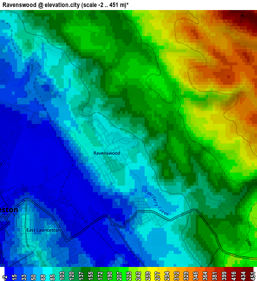
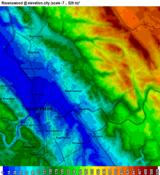
Below is the Elevation map of Ravenswood, which displays elevation range with different colors. Scale of the first map is from -2 to 451 m (-7 to 1480 ft) with average elevation of 131.5 meters (=431 ft) [note 1]
These maps also provides idea of topography and contour of this city, they are displayed at different zoom levels. More info about maps, scale and edge coordinates you can find below images.
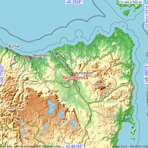
| \ | Map #1 | Map #2 | Topo.Map |
| Scale [m] | -2..451 m | -7..529 m | × |
| Scale [ft] | -7..1480 ft | -23..1736 ft | × |
| Average | 131.5 m = 431 ft | 178.1 m = 584 ft | × |
| Width | 7.33 km = 4.6 mi | 14.66 km = 9.1 mi | 234.5 km = 145.7 mi |
| Height | 7.33 km = 4.6 mi | 14.66 km = 9.1 mi | 234.5 km = 145.7 mi |
| ↑Max Latitude | -41.382966° | -41.349985° | -40.3528° |
| Latitude at center | -41.41593° | -41.41593° | -41.41593° |
| ↓Min Latitude | -41.448877° | -41.481808° | -42.46194° |
| ← Min Longitude | 147.138555° | 147.094609° | 145.77625° |
| Longitude center | 147.1825° | 147.1825° | 147.1825° |
| →Max Longitude | 147.226445° | 147.270391° | 148.58875° |
Nearby cities:
Cities around Ravenswood sort by population:
• Launceston elevation 82 m
4.7 km,  237°
237°
• Newstead 9 m
3.3 km,  211°
211°
• South Launceston 46 m
5.3 km,  215°
215°
• Launceston city centre 24 m
4.2 km, 242°
• Mowbray 50 m
3.1 km,  299°
299°
• Norwood 62 m
4.8 km,  181°
181°
• Invermay 6 m
4.1 km,  263°
263°
• East Launceston 40 m
3.6 km,  226°
226°
• Saint Leonards 135 m
4.8 km,  162°
162°
• Waverley 59 m
2.3 km,  172°
172°
• Mayfield 76 m
5.4 km,  306°
306°
• Rocherlea 154 m
4.4 km,  331°
331°
Multilingual:
 En español:
Ravenswood elevación 90 m.
 En France:
Ravenswood élévation 90 m.
 Auf Deutsch:
Ravenswood höhe über dem Meeresspiegel ist 90 m.

Sources and notes:
- [note 1] Map square and city borders are not equal. Map elevation data is calculated only from area inside that square.
- [src 1] Elevation data from geonames database provided with same terms of usage.
- [src 2] The elevation map of Ravenswood is generated using elevation data from NASA's 3 arcsec (90m) resolution SRTM data.
- [src 3] Base (background) map © OpenStreetMap contributors tiles are generated by Geofabrik and OpenTopoMap.
Copyright & License:
This Ravenswood Elevation Map is licensed under CC BY-SA. You may reuse any part from this page, if you give a proper credit by linking to this URL:
 More info on terms of use page.