Valentine elevation
Valentine (New South Wales, Lake Macquarie Shire), Australia elevation is 46 meters and Valentine elevation in feet is 151 ft above sea level [src 1]. Valentine is a section of populated place (feature code) with elevation that is 67 meters (220 ft) smaller than average city elevation in Australia.
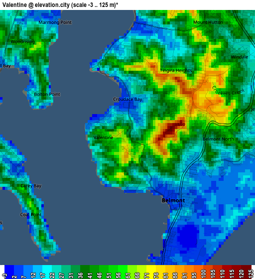
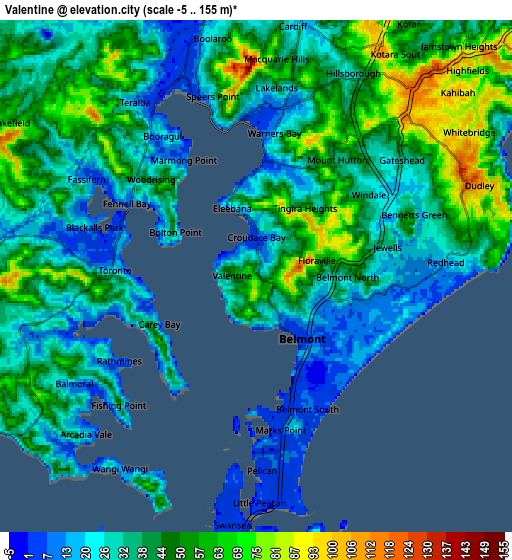
Below is the Elevation map of Valentine, which displays elevation range with different colors. Scale of the first map is from -3 to 125 m (-10 to 410 ft) with average elevation of 33 meters (=108 ft) [note 1]
These maps also provides idea of topography and contour of this city, they are displayed at different zoom levels. More info about maps, scale and edge coordinates you can find below images.
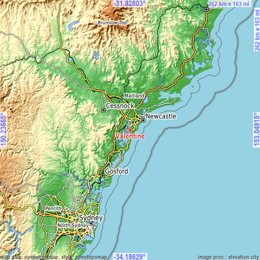
| \ | Map #1 | Map #2 | Topo.Map |
| Scale [m] | -3..125 m | -5..155 m | × |
| Scale [ft] | -10..410 ft | -16..509 ft | × |
| Average | 33 m = 108 ft | 39.6 m = 130 ft | × |
| Width | 8.19 km = 5.1 mi | 16.39 km = 10.2 mi | 262.2 km = 162.9 mi |
| Height | 8.19 km = 5.1 mi | 16.39 km = 10.2 mi | 262.2 km = 162.9 mi |
| ↑Max Latitude | -32.978183° | -32.941311° | -31.82803° |
| Latitude at center | -33.01504° | -33.01504° | -33.01504° |
| ↓Min Latitude | -33.051882° | -33.088708° | -34.18629° |
| ← Min Longitude | 151.598955° | 151.555009° | 150.23665° |
| Longitude center | 151.6429° | 151.6429° | 151.6429° |
| →Max Longitude | 151.686845° | 151.730791° | 153.04915° |
Nearby cities:
Cities around Valentine sort by population:
• Belmont elevation 29 m
2.1 km,  130°
130°
• Belmont North 27 m
2.5 km,  105°
105°
• Eleebana 11 m
2.9 km,  347°
347°
• Mount Hutton 43 m
4.3 km,  35°
35°
• Windale 34 m
4.4 km,  55°
55°
• Jewells 20 m
3.7 km,  87°
87°
• Tingira Heights 87 m
3.2 km,  52°
52°
• Bolton Point 18 m
3.4 km,  295°
295°
• Floraville 58 m
2.1 km,  78°
78°
• Marks Point 3 m
4.6 km,  172°
172°
• Coal Point 26 m
4.2 km,  223°
223°
• Belmont South 5 m
4 km,  161°
161°
Multilingual:
 En español:
Valentine elevación 46 m.
 En France:
Valentine élévation 46 m.
 Auf Deutsch:
Valentine höhe über dem Meeresspiegel ist 46 m.

Sources and notes:
- [note 1] Map square and city borders are not equal. Map elevation data is calculated only from area inside that square.
- [src 1] Elevation data from geonames database provided with same terms of usage.
- [src 2] The elevation map of Valentine is generated using elevation data from NASA's 3 arcsec (90m) resolution SRTM data.
- [src 3] Base (background) map © OpenStreetMap contributors tiles are generated by Geofabrik and OpenTopoMap.
Copyright & License:
This Valentine Elevation Map is licensed under CC BY-SA. You may reuse any part from this page, if you give a proper credit by linking to this URL:
 More info on terms of use page.