Dinner Plain elevation
Dinner Plain (Victoria, Alpine), Australia elevation is 1585 meters and Dinner Plain elevation in feet is 5200 ft above sea level [src 1]. Dinner Plain is a section of populated place (feature code) with elevation that is 1472 meters (4829 ft) bigger than average city elevation in Australia.
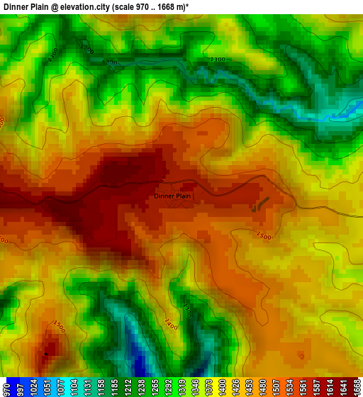
Below is the Elevation map of Dinner Plain, which displays elevation range with different colors. Scale of the first map is from 970 to 1668 m (3182 to 5472 ft) with average elevation of 1394.9 meters (=4576 ft) [note 1]
These maps also provides idea of topography and contour of this city, they are displayed at different zoom levels. More info about maps, scale and edge coordinates you can find below images.
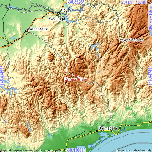
| \ | Map #1 | Topo.Map |
| Scale [m] | 970..1668 m | × |
| Scale [ft] | 3182..5472 ft | × |
| Average | 1394.9 m = 4576 ft | × |
| Width | 7.8 km = 4.8 mi | 249.7 km = 155.2 mi |
| Height | 7.8 km = 4.8 mi | 249.7 km = 155.2 mi |
| ↑Max Latitude | -36.988507° | -35.8926° |
| Latitude at center | -37.0236° | -37.0236° |
| ↓Min Latitude | -37.058677° | -38.13801° |
| ← Min Longitude | 147.197295° | 145.83499° |
| Longitude center | 147.24124° | 147.24124° |
| →Max Longitude | 147.285185° | 148.64749° |
Nearby cities:
Cities around Dinner Plain sort by population:
• Bairnsdale elevation 26 m
94.7 km,  159°
159°
• Beechworth 548 m
89 km,  326°
326°
• Falls Creek 1592 m
17.9 km,  10°
10°
• Myrtleford 210 m
69.1 km,  318°
318°
• Mount Buller 1715 m
72.6 km,  259°
259°
• Bright 315 m
41.1 km, 322°
• Hotham Heights 1701 m
8.6 km,  293°
293°
• Yackandandah 285 m
86.7 km,  335°
335°
• Wy Yung 79 m
91.5 km, 160°
• Lucknow 19 m
95.3 km, 157°
• Briagolong 63 m
92.4 km,  189°
189°
• Tallangatta 213 m
89.8 km,  356°
356°
Multilingual:
 En español:
Dinner Plain elevación 1585 m.
 En France:
Dinner Plain élévation 1585 m.
 Auf Deutsch:
Dinner Plain höhe über dem Meeresspiegel ist 1585 m.

Sources and notes:
- [note 1] Map square and city borders are not equal. Map elevation data is calculated only from area inside that square.
- [src 1] Elevation data from geonames database provided with same terms of usage.
- [src 2] The elevation map of Dinner Plain is generated using elevation data from NASA's 3 arcsec (90m) resolution SRTM data.
- [src 3] Base (background) map © OpenStreetMap contributors tiles are generated by Geofabrik and OpenTopoMap.
Copyright & License:
This Dinner Plain Elevation Map is licensed under CC BY-SA. You may reuse any part from this page, if you give a proper credit by linking to this URL:
 More info on terms of use page.