Mundoolun elevation
Mundoolun (Queensland, Logan), Australia elevation is 112 meters and Mundoolun elevation in feet is 367 ft above sea level [src 1]. Mundoolun is a section of populated place (feature code) with elevation that is 1 meters (3 ft) smaller than average city elevation in Australia.
Below is the Elevation map of Mundoolun, which displays elevation range with different colors. Scale of the first map is from 31 to 311 m (102 to 1020 ft) with average elevation of 91.5 meters (=300 ft) [note 1]
These maps also provides idea of topography and contour of this city, they are displayed at different zoom levels. More info about maps, scale and edge coordinates you can find below images.
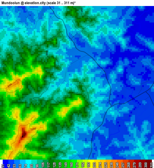
| \ | Map #1 | Topo.Map |
| Scale [m] | 31..311 m | × |
| Scale [ft] | 102..1020 ft | × |
| Average | 91.5 m = 300 ft | × |
| Width | 8.64 km = 5.4 mi | 276.4 km = 171.7 mi |
| Height | 8.64 km = 5.4 mi | 276.4 km = 171.7 mi |
| ↑Max Latitude | -27.860555° | -26.64953° |
| Latitude at center | -27.8994° | -27.8994° |
| ↓Min Latitude | -27.938231° | -29.135° |
| ← Min Longitude | 153.027555° | 151.66525° |
| Longitude center | 153.0715° | 153.0715° |
| →Max Longitude | 153.115445° | 154.47775° |
Nearby cities:
Cities around Mundoolun sort by population:
• Jimboomba elevation 43 m
8.7 km,  330°
330°
• Tamborine Mountain 525 m
14.8 km,  121°
121°
• Beaudesert 59 m
12.2 km,  217°
217°
• Logan Village 20 m
15 km,  13°
13°
• Tamborine 50 m
6.3 km,  73°
73°
• Yarrabilba 115 m
10.8 km,  21°
21°
• Cedar Vale 120 m
4.3 km,  285°
285°
• Cedar Grove 55 m
9.4 km, 292°
• Gleneagle 57 m
9.4 km,  246°
246°
• North Maclean 37 m
15.6 km,  339°
339°
• South Maclean 39 m
13.1 km, 335°
• Wongawallan 90 m
15.7 km,  80°
80°
Multilingual:
 En español:
Mundoolun elevación 112 m.
 En France:
Mundoolun élévation 112 m.
 Auf Deutsch:
Mundoolun höhe über dem Meeresspiegel ist 112 m.

Sources and notes:
- [note 1] Map square and city borders are not equal. Map elevation data is calculated only from area inside that square.
- [src 1] Elevation data from geonames database provided with same terms of usage.
- [src 2] The elevation map of Mundoolun is generated using elevation data from NASA's 3 arcsec (90m) resolution SRTM data.
- [src 3] Base (background) map © OpenStreetMap contributors tiles are generated by Geofabrik and OpenTopoMap.
Copyright & License:
This Mundoolun Elevation Map is licensed under CC BY-SA. You may reuse any part from this page, if you give a proper credit by linking to this URL:
 More info on terms of use page.