Sadleir elevation
Sadleir (New South Wales, Liverpool), Australia elevation is 22 meters and Sadleir elevation in feet is 72 ft above sea level [src 1]. Sadleir is a section of populated place (feature code) with elevation that is 91 meters (299 ft) smaller than average city elevation in Australia.
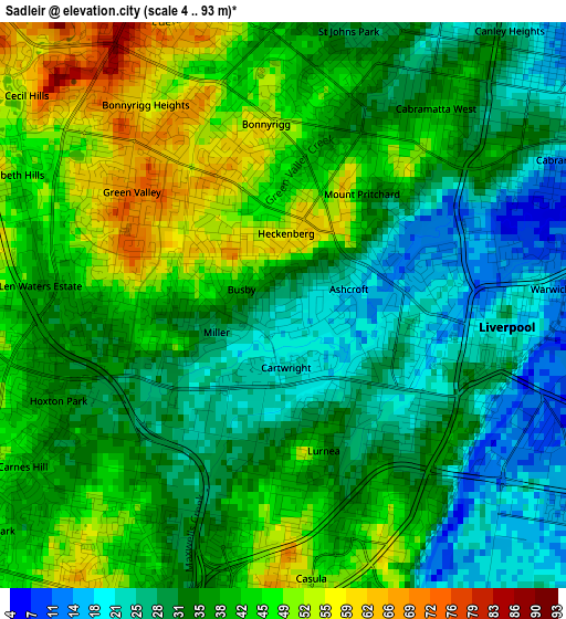
Below is the Elevation map of Sadleir, which displays elevation range with different colors. Scale of the first map is from 4 to 93 m (13 to 305 ft) with average elevation of 36.8 meters (=121 ft) [note 1]
These maps also provides idea of topography and contour of this city, they are displayed at different zoom levels. More info about maps, scale and edge coordinates you can find below images.
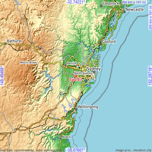
| \ | Map #1 | Topo.Map |
| Scale [m] | 4..93 m | × |
| Scale [ft] | 13..305 ft | × |
| Average | 36.8 m = 121 ft | × |
| Width | 8.11 km = 5 mi | 259.5 km = 161.2 mi |
| Height | 8.11 km = 5 mi | 259.5 km = 161.2 mi |
| ↑Max Latitude | -33.880654° | -32.74221° |
| Latitude at center | -33.91713° | -33.91713° |
| ↓Min Latitude | -33.95359° | -35.07607° |
| ← Min Longitude | 150.846985° | 149.48468° |
| Longitude center | 150.89093° | 150.89093° |
| →Max Longitude | 150.934875° | 152.29718° |
Nearby cities:
Cities around Sadleir sort by population:
• Liverpool elevation 11 m
3.2 km,  94°
94°
• Green Valley 72 m
2.7 km,  305°
305°
• Hinchinbrook 40 m
2.6 km,  265°
265°
• Mount Pritchard 32 m
2 km,  38°
38°
• Lurnea 34 m
2.1 km,  165°
165°
• Bonnyrigg 52 m
2.6 km,  356°
356°
• Cabramatta West 46 m
3.3 km, 35°
• Busby 66 m
1.2 km,  304°
304°
• Ashcroft 18 m
0.8 km,  81°
81°
• Miller 25 m
0.7 km,  234°
234°
• Heckenberg 55 m
1 km,  354°
354°
• Cartwright 21 m
0.9 km,  188°
188°
Multilingual:
 En español:
Sadleir elevación 22 m.
 En France:
Sadleir élévation 22 m.


Sources and notes:
- [note 1] Map square and city borders are not equal. Map elevation data is calculated only from area inside that square.
- [src 1] Elevation data from geonames database provided with same terms of usage.
- [src 2] The elevation map of Sadleir is generated using elevation data from NASA's 3 arcsec (90m) resolution SRTM data.
- [src 3] Base (background) map © OpenStreetMap contributors tiles are generated by Geofabrik and OpenTopoMap.
Copyright & License:
This Sadleir Elevation Map is licensed under CC BY-SA. You may reuse any part from this page, if you give a proper credit by linking to this URL:
 More info on terms of use page.