Mile End elevation
Mile End (South Australia, City of West Torrens), Australia elevation is 23 meters and Mile End elevation in feet is 75 ft above sea level [src 1]. Mile End is a section of populated place (feature code) with elevation that is 90 meters (295 ft) smaller than average city elevation in Australia.
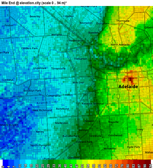
Below is the Elevation map of Mile End, which displays elevation range with different colors. Scale of the first map is from 0 to 94 m (0 to 308 ft) with average elevation of 28.2 meters (=93 ft) [note 1]
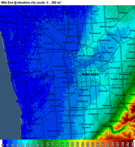
These maps also provides idea of topography and contour of this city, they are displayed at different zoom levels. More info about maps, scale and edge coordinates you can find below images.
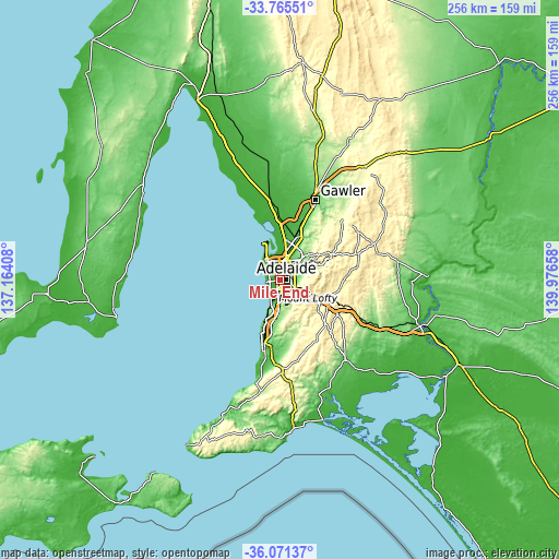
| \ | Map #1 | Map #2 | Topo.Map |
| Scale [m] | 0..94 m | -3..366 m | × |
| Scale [ft] | 0..308 ft | -10..1201 ft | × |
| Average | 28.2 m = 93 ft | 46.3 m = 152 ft | × |
| Width | 8.01 km = 5 mi | 16.02 km = 10 mi | 256.4 km = 159.3 mi |
| Height | 8.01 km = 5 mi | 16.02 km = 10 mi | 256.4 km = 159.3 mi |
| ↑Max Latitude | -34.890502° | -34.854448° | -33.76551° |
| Latitude at center | -34.92654° | -34.92654° | -34.92654° |
| ↓Min Latitude | -34.962562° | -34.998569° | -36.07137° |
| ← Min Longitude | 138.526385° | 138.482439° | 137.16408° |
| Longitude center | 138.57033° | 138.57033° | 138.57033° |
| →Max Longitude | 138.614275° | 138.658221° | 139.97658° |
Nearby cities:
Cities around Mile End sort by population:
• Adelaide elevation 56 m
2.6 km,  95°
95°
• Torrensville 22 m
1.1 km,  309°
309°
• Richmond 18 m
1.8 km,  200°
200°
• Kurralta Park 26 m
2.8 km,  186°
186°
• Underdale 12 m
2.3 km,  294°
294°
• Marleston 20 m
2.5 km, 202°
• Wayville 37 m
2.8 km,  136°
136°
• West Hindmarsh 21 m
2.1 km,  344°
344°
• Thebarton 22 m
1.1 km, 343°
• Cowandilla 14 m
1.2 km,  237°
237°
• Forestville 33 m
2.7 km,  163°
163°
• Ashford 32 m
2.5 km,  171°
171°
Multilingual:
 En español:
Mile End elevación 23 m.
 En France:
Mile End élévation 23 m.


Sources and notes:
- [note 1] Map square and city borders are not equal. Map elevation data is calculated only from area inside that square.
- [src 1] Elevation data from geonames database provided with same terms of usage.
- [src 2] The elevation map of Mile End is generated using elevation data from NASA's 3 arcsec (90m) resolution SRTM data.
- [src 3] Base (background) map © OpenStreetMap contributors tiles are generated by Geofabrik and OpenTopoMap.
Copyright & License:
This Mile End Elevation Map is licensed under CC BY-SA. You may reuse any part from this page, if you give a proper credit by linking to this URL:
 More info on terms of use page.