McMahons Point elevation
McMahons Point (New South Wales, North Sydney), Australia elevation is 41 meters and McMahons Point elevation in feet is 135 ft above sea level [src 1]. McMahons Point is a section of populated place (feature code) with elevation that is 72 meters (236 ft) smaller than average city elevation in Australia.
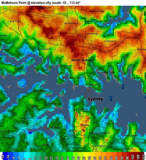
Below is the Elevation map of McMahons Point, which displays elevation range with different colors. Scale of the first map is from -19 to 113 m (-62 to 371 ft) with average elevation of 43.4 meters (=142 ft) [note 1]
These maps also provides idea of topography and contour of this city, they are displayed at different zoom levels. More info about maps, scale and edge coordinates you can find below images.
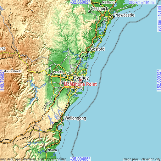
| \ | Map #1 | Topo.Map |
| Scale [m] | -19..113 m | × |
| Scale [ft] | -62..371 ft | × |
| Average | 43.4 m = 142 ft | × |
| Width | 8.12 km = 5 mi | 259.7 km = 161.4 mi |
| Height | 8.12 km = 5 mi | 259.7 km = 161.4 mi |
| ↑Max Latitude | -33.808414° | -32.66902° |
| Latitude at center | -33.84492° | -33.84492° |
| ↓Min Latitude | -33.881411° | -35.00485° |
| ← Min Longitude | 151.159125° | 149.79682° |
| Longitude center | 151.20307° | 151.20307° |
| →Max Longitude | 151.247015° | 152.60932° |
Nearby cities:
Cities around McMahons Point sort by population:
• Neutral Bay elevation 43 m
1.5 km,  59°
59°
• Wollstonecraft 46 m
1.8 km,  317°
317°
• North Sydney 84 m
0.8 km,  30°
30°
• Greenwich 32 m
1.9 km,  287°
287°
• Kirribilli 52 m
1.3 km,  108°
108°
• Birchgrove 28 m
2 km,  248°
248°
• Waverton 57 m
0.7 km,  340°
340°
• Milsons Point 49 m
0.8 km,  98°
98°
• The Rocks 19 m
1.7 km,  163°
163°
• Balmain East 34 m
1.7 km,  214°
214°
• Millers Point 31 m
1.6 km,  176°
176°
• Kurraba Point 25 m
1.8 km,  80°
80°
Multilingual:
 En español:
McMahons Point elevación 41 m.
 En France:
McMahons Point élévation 41 m.
 Auf Deutsch:
McMahons Point höhe über dem Meeresspiegel ist 41 m.

Sources and notes:
- [note 1] Map square and city borders are not equal. Map elevation data is calculated only from area inside that square.
- [src 1] Elevation data from geonames database provided with same terms of usage.
- [src 2] The elevation map of McMahons Point is generated using elevation data from NASA's 3 arcsec (90m) resolution SRTM data.
- [src 3] Base (background) map © OpenStreetMap contributors tiles are generated by Geofabrik and OpenTopoMap.
Copyright & License:
This McMahons Point Elevation Map is licensed under CC BY-SA. You may reuse any part from this page, if you give a proper credit by linking to this URL:
 More info on terms of use page.