Greystanes elevation
Greystanes (New South Wales, Cumberland), Australia elevation is 73 meters and Greystanes elevation in feet is 240 ft above sea level [src 1]. Greystanes is a section of populated place (feature code) with elevation that is 40 meters (131 ft) smaller than average city elevation in Australia.
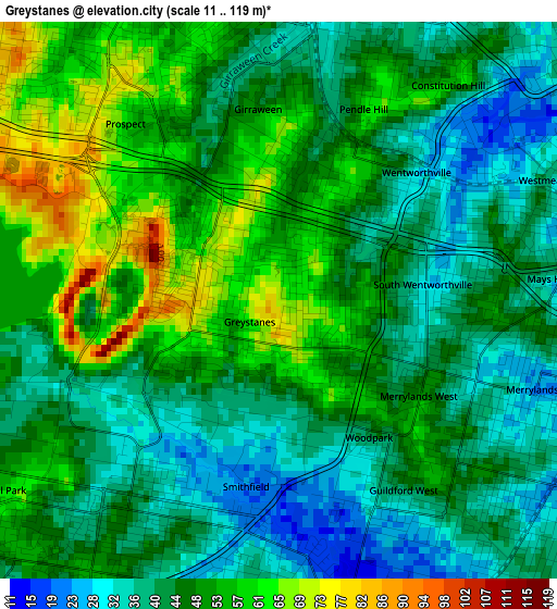
Below is the Elevation map of Greystanes, which displays elevation range with different colors. Scale of the first map is from 11 to 119 m (36 to 390 ft) with average elevation of 46.9 meters (=154 ft) [note 1]
These maps also provides idea of topography and contour of this city, they are displayed at different zoom levels. More info about maps, scale and edge coordinates you can find below images.
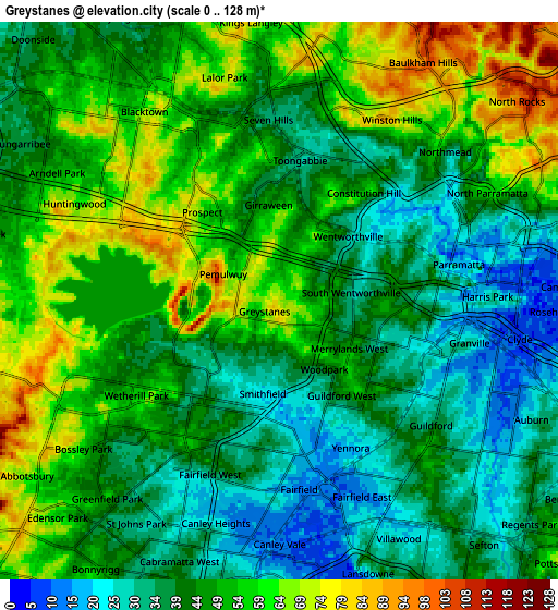
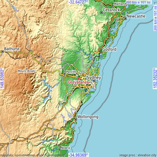
| \ | Map #1 | Map #2 | Topo.Map |
| Scale [m] | 11..119 m | 0..128 m | × |
| Scale [ft] | 36..390 ft | 0..420 ft | × |
| Average | 46.9 m = 154 ft | 47.2 m = 155 ft | × |
| Width | 8.12 km = 5 mi | 16.24 km = 10.1 mi | 259.8 km = 161.4 mi |
| Height | 8.12 km = 5 mi | 16.24 km = 10.1 mi | 259.8 km = 161.4 mi |
| ↑Max Latitude | -33.786944° | -33.750413° | -32.64727° |
| Latitude at center | -33.82346° | -33.82346° | -33.82346° |
| ↓Min Latitude | -33.85996° | -33.896445° | -34.98369° |
| ← Min Longitude | 150.902125° | 150.858179° | 149.53982° |
| Longitude center | 150.94607° | 150.94607° | 150.94607° |
| →Max Longitude | 150.990015° | 151.033961° | 152.35232° |
Nearby cities:
Cities around Greystanes sort by population:
• Merrylands elevation 25 m
3.6 km,  107°
107°
• Smithfield 29 m
3.2 km,  201°
201°
• Wentworthville 45 m
2.8 km,  46°
46°
• Pendle Hill 59 m
2.3 km,  21°
21°
• Merrylands West 42 m
2.4 km,  115°
115°
• South Wentworthville 50 m
1.7 km,  71°
71°
• Girraween 54 m
2.7 km,  354°
354°
• Pemulwuy 58 m
2 km,  272°
272°
• Guildford West 38 m
3.4 km,  149°
149°
• Prospect 80 m
3.9 km,  309°
309°
• Constitution Hill 46 m
4.4 km,  39°
39°
• Woodpark 43 m
2.4 km, 146°
Multilingual:
 En español:
Greystanes elevación 73 m.
 En France:
Greystanes élévation 73 m.
 Auf Deutsch:
Greystanes höhe über dem Meeresspiegel ist 73 m.

Sources and notes:
- [note 1] Map square and city borders are not equal. Map elevation data is calculated only from area inside that square.
- [src 1] Elevation data from geonames database provided with same terms of usage.
- [src 2] The elevation map of Greystanes is generated using elevation data from NASA's 3 arcsec (90m) resolution SRTM data.
- [src 3] Base (background) map © OpenStreetMap contributors tiles are generated by Geofabrik and OpenTopoMap.
Copyright & License:
This Greystanes Elevation Map is licensed under CC BY-SA. You may reuse any part from this page, if you give a proper credit by linking to this URL:
 More info on terms of use page.