Glendenning elevation
Glendenning (New South Wales, Blacktown), Australia elevation is 36 meters and Glendenning elevation in feet is 118 ft above sea level [src 1]. Glendenning is a section of populated place (feature code) with elevation that is 77 meters (253 ft) smaller than average city elevation in Australia.
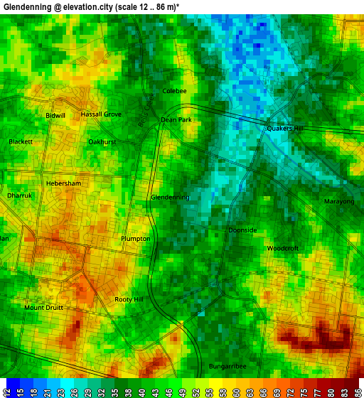
Below is the Elevation map of Glendenning, which displays elevation range with different colors. Scale of the first map is from 12 to 86 m (39 to 282 ft) with average elevation of 45.6 meters (=150 ft) [note 1]
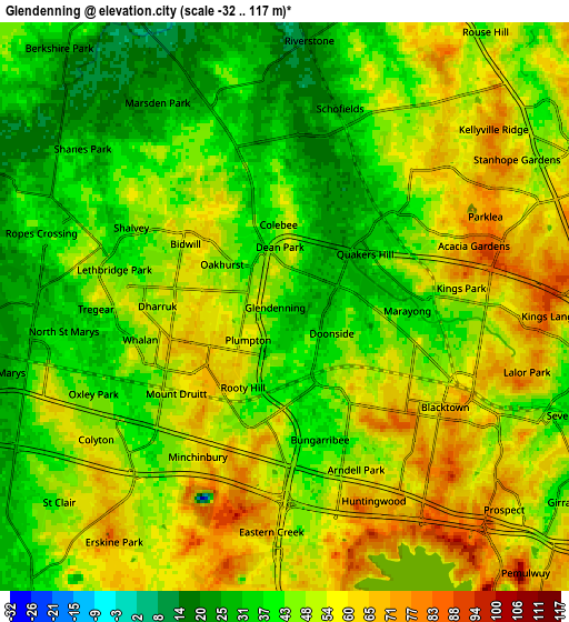
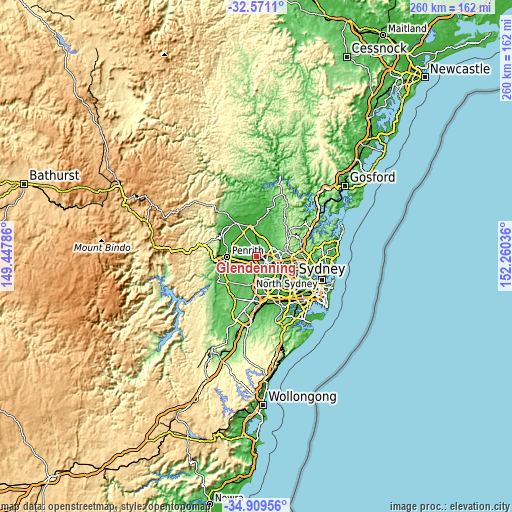
These maps also provides idea of topography and contour of this city, they are displayed at different zoom levels. More info about maps, scale and edge coordinates you can find below images.
| \ | Map #1 | Map #2 | Topo.Map |
| Scale [m] | 12..86 m | -32..117 m | × |
| Scale [ft] | 39..282 ft | -105..384 ft | × |
| Average | 45.6 m = 150 ft | 47.8 m = 157 ft | × |
| Width | 8.13 km = 5.1 mi | 16.25 km = 10.1 mi | 260 km = 161.6 mi |
| Height | 8.13 km = 5.1 mi | 16.25 km = 10.1 mi | 260 km = 161.6 mi |
| ↑Max Latitude | -33.711752° | -33.675189° | -32.5711° |
| Latitude at center | -33.7483° | -33.7483° | -33.7483° |
| ↓Min Latitude | -33.784832° | -33.821349° | -34.90956° |
| ← Min Longitude | 150.810165° | 150.766219° | 149.44786° |
| Longitude center | 150.85411° | 150.85411° | 150.85411° |
| →Max Longitude | 150.898055° | 150.942001° | 152.26036° |
Nearby cities:
Cities around Glendenning sort by population:
• Quakers Hill elevation 39 m
3.2 km,  58°
58°
• Rooty Hill 65 m
2.8 km,  223°
223°
• Doonside 46 m
2.3 km,  150°
150°
• Plumpton 58 m
1.6 km,  256°
256°
• Oakhurst 44 m
1.8 km,  305°
305°
• Woodcroft 40 m
2.6 km,  110°
110°
• Hebersham 61 m
2.8 km,  275°
275°
• Hassall Grove 49 m
2.4 km, 313°
• Blackett 58 m
3.5 km,  289°
289°
• Dean Park 40 m
1.5 km,  19°
19°
• Bungarribee 40 m
3.4 km,  158°
158°
• Colebee 34 m
2.4 km,  344°
344°
Multilingual:
 En español:
Glendenning elevación 36 m.
 En France:
Glendenning élévation 36 m.
 Auf Deutsch:
Glendenning höhe über dem Meeresspiegel ist 36 m.

Sources and notes:
- [note 1] Map square and city borders are not equal. Map elevation data is calculated only from area inside that square.
- [src 1] Elevation data from geonames database provided with same terms of usage.
- [src 2] The elevation map of Glendenning is generated using elevation data from NASA's 3 arcsec (90m) resolution SRTM data.
- [src 3] Base (background) map © OpenStreetMap contributors tiles are generated by Geofabrik and OpenTopoMap.
Copyright & License:
This Glendenning Elevation Map is licensed under CC BY-SA. You may reuse any part from this page, if you give a proper credit by linking to this URL:
 More info on terms of use page.