Emerton elevation
Emerton (New South Wales, Blacktown), Australia elevation is 51 meters and Emerton elevation in feet is 167 ft above sea level [src 1]. Emerton is a section of populated place (feature code) with elevation that is 62 meters (203 ft) smaller than average city elevation in Australia.
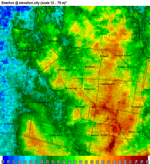
Below is the Elevation map of Emerton, which displays elevation range with different colors. Scale of the first map is from 12 to 79 m (39 to 259 ft) with average elevation of 42.5 meters (=139 ft) [note 1]
These maps also provides idea of topography and contour of this city, they are displayed at different zoom levels. More info about maps, scale and edge coordinates you can find below images.
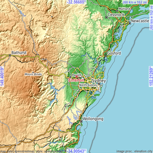
| \ | Map #1 | Topo.Map |
| Scale [m] | 12..79 m | × |
| Scale [ft] | 39..259 ft | × |
| Average | 42.5 m = 139 ft | × |
| Width | 8.13 km = 5.1 mi | 260 km = 161.6 mi |
| Height | 8.13 km = 5.1 mi | 260 km = 161.6 mi |
| ↑Max Latitude | -33.707561° | -32.56685° |
| Latitude at center | -33.74411° | -33.74411° |
| ↓Min Latitude | -33.780644° | -34.90543° |
| ← Min Longitude | 150.762495° | 149.40019° |
| Longitude center | 150.80644° | 150.80644° |
| →Max Longitude | 150.850385° | 152.21269° |
Nearby cities:
Cities around Emerton sort by population:
• Mount Druitt elevation 47 m
2.7 km,  159°
159°
• Ropes Crossing 47 m
1.9 km,  311°
311°
• Whalan 40 m
1.4 km,  188°
188°
• Hebersham 61 m
1.6 km,  96°
96°
• Lethbridge Park 42 m
1 km,  324°
324°
• Bidwill 58 m
2.1 km,  43°
43°
• Tregear 52 m
1.3 km,  262°
262°
• North St Marys 35 m
2.4 km,  239°
239°
• Shalvey 40 m
1.9 km,  356°
356°
• Blackett 58 m
1.3 km,  57°
57°
• Dharruk 49 m
1 km,  117°
117°
• Willmot 41 m
2.4 km,  328°
328°
Multilingual:
 En español:
Emerton elevación 51 m.
 En France:
Emerton élévation 51 m.


Sources and notes:
- [note 1] Map square and city borders are not equal. Map elevation data is calculated only from area inside that square.
- [src 1] Elevation data from geonames database provided with same terms of usage.
- [src 2] The elevation map of Emerton is generated using elevation data from NASA's 3 arcsec (90m) resolution SRTM data.
- [src 3] Base (background) map © OpenStreetMap contributors tiles are generated by Geofabrik and OpenTopoMap.
Copyright & License:
This Emerton Elevation Map is licensed under CC BY-SA. You may reuse any part from this page, if you give a proper credit by linking to this URL:
 More info on terms of use page.